Córdoba-Navarco Fault
| Córdoba-Navarco Fault | |
|---|---|
| Falla Córdoba-Navarco | |
 | |
| Etymology | Córdoba & Navarco River |
| Country |
|
| Region | Andean |
| State | Quindío |
| Characteristics | |
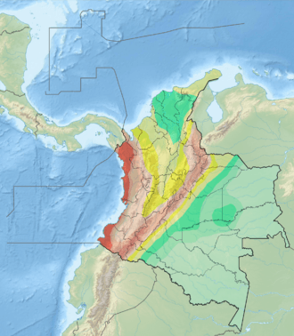
| Range | Central Ranges |
| Part of | Romeral Fault System |
| Length | 21.2 km (13.2 mi) |
| Strike | 018.5 ± 4 |
| Dip | Vertical |
| Displacement | <0.2 mm (0.0079 in)/yr |
| Tectonics | |
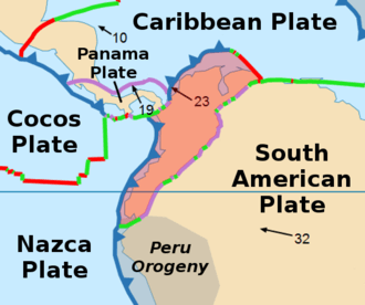
| Plate | North Andean |
| Status | Active |
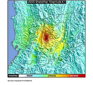
| Earthquakes | 1999 Armenia (Mw 6.1) |
| Type | Strike-slip fault |
| Movement | Sinistral |
| Rock units | Córdoba & Quebradagrande Complexes |
| Age | Quaternary |
| Orogeny | Andean |
The Córdoba-Navarco Fault (Spanish: Falla Córdoba-Navarco) is a sinistral strike-slip fault in the department of Quindío in west-central Colombia. The fault has a total length of 21.2 kilometres (13.2 mi) and runs along an average north-northeast to south-southwest strike of 018.5 ± 4 in the Central Ranges of the Colombian Andes.
The fault segment pertaining to the megaregional Romeral Fault System is a set of two faults that are active, causing the major 1999 Armenia earthquake with approximately 1185 fatalities.
Etymology
The fault is named after Córdoba and the Navarco River in Quindío.[1]
Description
The fault section is formed by the Córdoba and Navarco Faults, which are eastern strands of Romeral Fault System, south of the city of Armenia. These faults lie within the epicenter area of the Armenia earthquake of January 25, 1999. The faults extend through sheared cataclastic and undeformed basaltic and sedimentary Cretaceous oceanic rocks, cropping out on the eastern slope of the Central Ranges of Colombia.[1] It separates the Córdoba Complex from the Quebradagrande Complex.[2]
Well preserved fault trace controls stream draingages. The Córdoba-Navarco Fault forms fault saddles and eroded fault scarps. Neotectonic features are not very outstanding. Slopes in this part of the Central Ranges are rather steep, so erosion rate is high.[1]
The fault terminates in the south against the Ibagué Fault.[3]
Activity
On January 25, 1999 a major earthquake hit the capitals of Quindío, Armenia, and Risaralda, Pereira. The earthquake had a moment magnitude of 6.1 and an intensity of X and occurred at a depth of 17.0 kilometres (55,800 ft).[4] The natural disaster caused around 1185 casualties in central Colombia and was the strongest earthquake in 16 years.[5]
See also
References
- 1 2 3 Paris et al., 2000a, p.25
- ↑ Mapa Geológico de Quindío, 2000
- ↑ Paris et al., 2000b
- ↑ USGS. "M 6.1 - Colombia". United States Geological Survey. Retrieved 2017-09-18.
- ↑ Various Authors, 1999, p.10
Bibliography
- Paris, Gabriel; Michael N. Machette; Richard L. Dart, and Kathleen M. Haller. 2000a. Map and Database of Quaternary Faults and Folds in Colombia and its Offshore Regions, 1–66. USGS. Accessed 2017-09-18.
- Various, Authors. 1999. El terremoto de enero de 1999 en Colombia: Impacto socioeconómico del desastre en la zona del Eje Cafetero, 1–89. CEPAL. Accessed 2017-09-24.
Maps
- Paris, Gabriel; Michael N. Machette; Richard L. Dart, and Kathleen M. Haller. 2000b. Map of Quaternary Faults and Folds of Colombia and Its Offshore Regions, 1. USGS. Accessed 2017-09-18.
- Mosquera, D. 2000. Mapa Geológico de Quindío 1:100,000, 1. INGEOMINAS. Accessed 2017-09-21.