List of tectonic plates
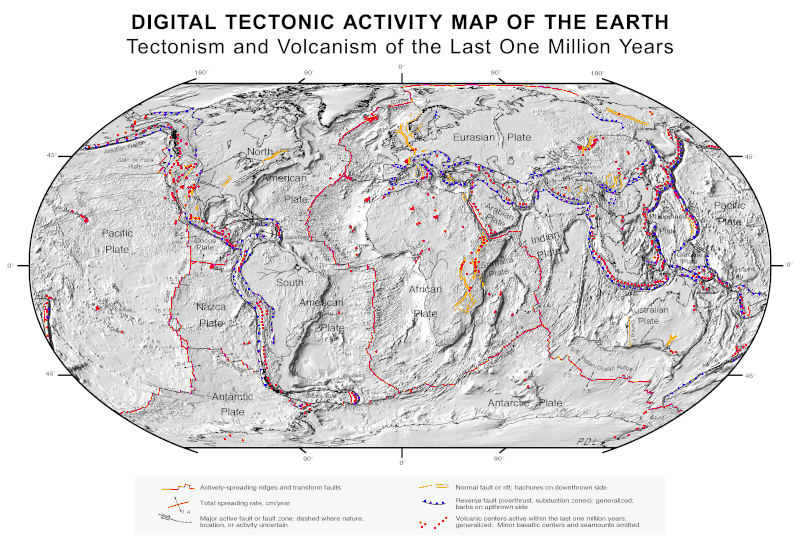
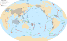
This is a list of tectonic plates on the Earth's surface. Tectonic plates are pieces of Earth's crust and uppermost mantle, together referred to as the lithosphere. The plates are around 100 km (62 mi) thick and consist of two principal types of material: oceanic crust (also called sima from silicon and magnesium) and continental crust (sial from silicon and aluminium). The composition of the two types of crust differs markedly, with mafic basaltic rocks dominating oceanic crust, while continental crust consists principally of lower-density felsic granitic rocks.
Current plates
Geologists generally agree that the following tectonic plates currently exist on the Earth's surface with roughly definable boundaries. Tectonic plates are sometimes subdivided into three fairly arbitrary categories: major (or primary) plates, minor (or secondary) plates, and microplates (or tertiary plates).
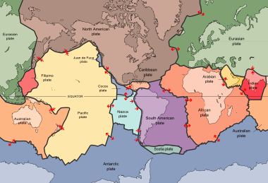
Major/main plates
These plates comprise the bulk of the continents and the Pacific Ocean. For purposes of this list, a major plate is any plate with an area greater than 20 million km2.
- Pacific Plate – An oceanic tectonic plate under the Pacific Ocean – 103,300,000 km2
- North American Plate – Large tectonic plate including most of North America, Greenland and a bit of Siberia – 75,900,000 km2
- Eurasian Plate – A tectonic plate which includes most of the continent of Eurasia – 67,800,000 km2
- African Plate – Tectonic plate underlying Africa west of the East African Rift – 61,300,000 km2
- Antarctic Plate – A tectonic plate containing the continent of Antarctica and extending outward under the surrounding oceans – 60,900,000 km2
- Indo-Australian Plate – A major tectonic plate formed by the fusion of the Indian and Australian plates – 58,900,000 km2 often considered two plates:
- Australian Plate – A major tectonic plate, originally a part of the ancient continent of Gondwana – 47,000,000 km2
- Indian Plate – A major tectonic plate once part of the supercontinent Gondwana – 11,900,000 km2
- South American Plate – A major tectonic plate which includes most of South America and a large part of the south Atlantic – 43,600,000 km2
Minor plates
These smaller plates are often not shown on major plate maps, as the majority do not comprise significant land area. For purposes of this list, a minor plate is any plate with an area less than 20 million km2 but greater than 1 million km2.
- Somali Plate – 16,700,000 km2
- Nazca Plate – 15,600,000 km2
- Philippine Plate – 5,500,000 km2
- Arabian Plate – 5,000,000 km2
- Caribbean Plate – 3,300,000 km2
- Cocos Plate – 2,900,000 km2
- Caroline Plate – 1,700,000 km2
- Scotia Plate – 1,600,000 km2
- Burma Plate – 1,100,000 km2
- New Hebrides Plate – 1,100,000 km2
Microplates
These plates are often grouped with an adjacent major plate on a major plate map. For purposes of this list, a microplate is any plate with an area less than 1 million km2. Some models identify more minor plates within current orogens (events that lead to a large structural deformation of the Earth's lithosphere) like the Apulian, Explorer, Gorda, and Philippine Mobile Belt plates. There may be scientific consensus as to whether such plates should be considered distinct portions of the crust; thus new research could change this list.[1][2][3][4]
- African Plate
- Lwandle Plate – A mainly oceanic tectonic microplate off the southeast coast of Africa
- Madagascar Plate – A tectonic plate formerly part of the supercontinent Gondwana
- Rovuma Plate – One of three tectonic microplates that contribute to the Nubian Plate and the Somali Plate
- Victoria Plate
- Seychelles microcontinent – A microcontinent underlying the Seychelles in the western Indian Ocean
- Antarctic Plate
- Shetland Plate – Tectonic microplate off the tip of the Antarctic Peninsula
- South Sandwich Plate – A minor tectonic plate south of the South American Plate
- Australian Plate
- Capricorn Plate – Proposed minor tectonic plate under the Indian Ocean
- Futuna Plate – A very small tectonic plate near the south Pacific island of Futuna
- Kermadec Plate – a long, narrow tectonic plate west of the Kermadec Trench
- Maoke Plate – A small tectonic plate in western New Guinea
- Niuafo'ou Plate – Small tectonic plate west of Tonga
- Tonga Plate – A small southwest Pacific tectonic plate
- Woodlark Plate – A small tectonic plate located in the eastern half of the island of New Guinea
- Caribbean Plate
- Panama Plate – A small tectonic plate sandwiched between the Cocos Plate and Nazca Plate to the south and the Caribbean Plate to the north
- Gonâve Microplate – Part of the boundary between the North American Plate and the Caribbean Plate
- South Jamaica Microplate[5]
- North Hispaniola Microplate[5]
- Puerto Rico-Virgin Islands Microplate
- Cocos Plate
- Rivera Plate – Small tectonic plate off the west coast of Mexico
- Eurasian Plate
- Adriatic Plate, also known as Apulian Plate – A small tectonic plate in the Mediterranean
- Aegean Sea Plate, also known as Hellenic Plate – A small tectonic plate in the eastern Mediterranean Sea
- Amurian Plate – A minor tectonic plate in eastern Asia
- Anatolian Plate – A continental tectonic plate comprising most of the Anatolia (Asia Minor) peninsula
- Banda Sea Plate – A minor tectonic plate underlying the Banda Sea in southeast Asia
- Iberian Plate – Small tectonic plate now part of the Eurasian plate
- Iranian Plate – Tectonic plate including Iran and Afghanistan, and parts of Pakistan and Iraq
- Molucca Sea Plate – A small fully subducted tectonic plate
- Halmahera Plate – A small tectonic plate in the Molucca Sea
- Sangihe Plate – A microplate within the Molucca Sea Collision Zone of eastern Indonesia
- Okinawa Plate – A minor tectonic plate from the northern end of Taiwan to the southern tip of Kyūshū
- Pelso Plate – A small tectonic unit in the Pannonian Basin in Europe
- Sunda Plate – A minor tectonic plate including most of Southeast Asia
- Timor Plate – A microplate in southeast Asia carrying the island of Timor and surrounding islands
- Tisza Plate – A tectonic microplate, in present-day Europe
- Yangtze Plate – A small tectonic plate carrying the bulk of southern China
- Nazca Plate
- Coiba Plate – A small tectonic plate off the coast south of Panama and northwestern Colombia
- Malpelo Plate – A small tectonic plate off the coast west of Ecuador and Colombia
- North American Plate
- Greenland Plate – A supposed tectonic plate containing the Greenland craton
- Okhotsk Plate – Minor tectonic plate inclucing the Sea of Okhotsk, the Kamchatka Peninsula, Sakhalin Island and Tōhoku and Hokkaidō in Japan
- Juan de Fuca Plate – A small tectonic plate in the western North Pacific
- Explorer Plate – An oceanic tectonic plate beneath the Pacific Ocean off the west coast of Vancouver Island, Canada
- Gorda Plate – One of the northern remnants of the Farallon Plate
- Pacific Plate
- Balmoral Reef Plate – A small tectonic plate in the south Pacific north of Fiji
- Bird's Head Plate – Small tectonic plate incorporating the Bird's Head Peninsula, at the western end of the island of New Guinea
- Caroline Plate – Minor oceanic tectonic plate north of New Guinea
- Conway Reef Plate – A small tectonic plate in the south Pacific west of Fiji
- Easter Plate
- Galapagos Microplate
- Juan Fernandez Plate
- Kula Plate – An oceanic tectonic plate under the northern Pacific Ocean which has been subducted under the North American Plate
- Manus Plate – A tiny tectonic plate northeast of New Guinea
- New Hebrides Plate – Minor tectonic plate in the Pacific Ocean near Vanuatu
- North Bismarck Plate – Small tectonic plate in the Bismarck Sea north of New Guinea
- North Galápagos Microplate
- Solomon Sea Plate – A minor tectonic plate to the northwest of the Solomon Islands in the south Pacific Ocean
- South Bismarck Plate – A small tectonic plate in the southern Bismarck Sea
- Philippine Sea Plate
- Mariana Plate – A small tectonic plate west of the Mariana Trench
- Philippine Microplate
- South American Plate
- Altiplano Plate
- Falklands Microplate
- North Andes Plate – A small tectonic plate in the northern Andes
Ancient continental formations
In the history of Earth many tectonic plates have come into existence and have over the intervening years either accreted onto other plates to form larger plates, rifted into smaller plates, or have been crushed by or subducted under other plates (or have done all three).
Ancient supercontinents
A supercontinent is a landmass consisting of multiple continental cores. The following list includes the supercontinents known or speculated to have existed in the Earth's past:
Ancient plates and cratons
Not all plate boundaries are easily defined, especially for ancient pieces of crust. The following list of ancient cratons, microplates, plates, shields, terranes, and zones no longer exist as separate plates. Cratons are the oldest and most stable parts of the continental lithosphere and shields are the exposed area of a craton(s). Microplates are tiny tectonic plates, terranes are fragments of crustal material formed on one tectonic plate and accreted to crust lying on another plate, and zones are bands of similar rocks on a plate formed by terrane accretion or native rock formation. Terranes may or may not have originated as independent microplates: a terrane may not contain the full thickness of the lithosphere.
African plate
- Atlantica
- Bangweulu Block (Zambia)
- Congo Craton (Angola, Cameroon, Central African Republic, Democratic Republic of Congo, Gabon, Sudan, and Zambia)
- Kaapvaal Craton (South Africa)
- Kalahari Craton (South Africa)
- Saharan Metacraton (Algeria)
- Sebakwe proto-Craton (Zimbabwe)
- Tanzanian Craton (Tanzania)
- West African Craton (Algeria, Benin, Burkina Faso, Côte d'Ivoire, Gambia, Ghana, Guinea, Guinea Bissau, Liberia, Mali, Mauritania, Morocco, Nigeria, Senegal, Sierra Leone, and Togo)
- Zaire Craton (Congo)
- Zimbabwe Craton (Zimbabwe)
Antarctica plate
Eurasian plate
- Armorica (France, Germany, Spain and Portugal)
- Avalonia (Canada, Great Britain, and United States)
- Baltic Plate (Russia)
- Belomorian Craton
- Central Iberian Plate (Spain)
- Cimmerian Plate (Anatolia, Iran, Afghanistan, Tibet, Indochina and Malaya)
- East China Craton (China)
- East European Craton (Russia and Scandinavia)
- Fennoscandian Shield (Norway, Sweden, and Finland)
- Junggar Plate (China)
- Hunic plate
- Karelian Craton (Finland and Russia)
- Kazakhstania (Kazakhstan)
- Kola Craton (northwest Russia)
- Lhasa terrane
- Massif Central
- Moldanubian Plate (Austria)
- Moravo Silesian Plate (Czech Republic)
- Midlands Microcraton (Great Britain)
- North Atlantic Craton
- North China Craton (China and Korea)
- Ossa-Morena Plate (Spain)
- Piemont-Liguria Plate
- Proto-Alps Terrane (Austria)
- Rhenohercynian Plate
- Sarmatian Craton (Ukraine)
- Saxothuringian Plate
- Siberian Craton (Russia)
- South Portuguese Plate (Portugal)
- Tarim Craton (China)
- Teplá-Barrandian Terrane (Czech Republic)
- Ukrainian Shield (Ukraine)
- Valais Plate
- Volgo-Uralian Craton, (Russia)
- Yakutai Craton, eastern (Russia)
- Yangtze Craton (China)
Indo-Australian plate
- Altjawarra Craton (Australia)
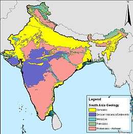
- Bhandara Craton, (India)
- Bundelkhand Craton, (India)
- Dharwar Craton, (India)
- Central Craton (Australia)
- Curnamona Craton (Australia)
- Gawler Craton (Australia)
- Indian Craton (India)
- Narooma Terrane (Australia)
- Pilbara Craton (Australia)
- Singhbhum Craton (India)
- Yilgarn Craton (Australia)
- Western Australian Shield (Australia)
- Zealandia, see Moa Plate and Lord Howe Rise (New Zealand)
North American plate
- Avalonia (Canada, Great Britain, and United States)
- Carolina Plate
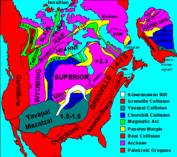
- Churchill Craton (Canada)
- Farallon Plate (split into the Cocos, Explorer, Juan de Fuca, Gorda Plates, Nazca Plate, and Rivera Plates)
- Florida Plate (United States)
- Hearne Craton (Canada)
- Laurentian Craton (Canada and United States)
- Insular Plate
- Intermontane Plate
- Izanagi Plate
- Mexican Plate (Mexico)
- Nain province (Canada)
- Newfoundland Plate (Canada)
- Nova Scotia Plate
- Rae Craton (Canada)
- Sask Craton (Canada)
- Sclavia Craton (Canada)
- Slave Craton (Canada)
- Superior Craton (Canada)
- Wyoming Craton (United States)
South American plate
- Amazonian craton (Brazil)
- Guiana Shield (Brazil, Colombia, French Guiana, Guyana, Suriname, and Venezuela)
- Rio Apas craton (Brazil, Paraguay)
- Río de la Plata craton (Argentina and Uruguay)
- São Francisco craton (Brazil)
- Arequipa–Antofalla craton (Argentina, Bolivia, Chile, Peru)
References
- ↑ Tetsuzo Seno, Taro Sakurai, and Seth Stein. 1996. Can the Okhotsk plate be discriminated from the North American plate? J. Geophys. Res., 101, 11305-11315 (abstract)
- ↑ Bird, P. (2003). "An updated digital model of plate boundaries". Geochemistry, Geophysics, Geosystems 4 (3): 1027. doi:10.1029/2001GC000252. http://peterbird.name/publications/2003_PB2002/2003_PB2002.htm.
- ↑ Timothy M. Kusky; Erkan Toraman & Tsilavo Raharimahefa (2006-11-20). "The Great Rift Valley of Madagascar: An extension of the Africa–Somali diffusive plate boundary?". International Association for Gondwana Research Published by Elsevier B.V.
- ↑ Niels Henriksen; A.K. Higgins; Feiko Kalsbeek; T. Christopher R. Pulvertaft (2000). "Greenland from Archaean to Quaternary" (PDF) (185). Greenland Survey Bulletin. Archived from the original (PDF) on 2008-12-07. Retrieved 2009-10-04.
- 1 2 Benford, B.; DeMets, C.; Calais, E. (2012). "GPS estimates of microplate motions, northern Caribbean: evidence for a Hispaniola microplate and implications for earthquake hazard" (PDF). Geophysical Journal International. Oxford, UK: Oxford University Press. 191 (2): 481–490. doi:10.1111/j.1365-246X.2012.05662.x. ISSN 0956-540X. Retrieved August 20, 2018.
External links
- Bird, Peter (2003) An updated digital model of plate boundaries also available as a large (13 Mb) PDF file