Cimitarra Fault
| Cimitarra Fault | |
|---|---|
| Falla de Cimitarra | |
 | |
| Etymology | Cimitarra River |
| Country |
|
| Region | Andean |
| State | Antioquia, Bolívar, Santander |
| Cities | Cantagallo, Puerto Wilches |
| Characteristics | |
| Range | Central Ranges, Andes |
| Part of | Andean oblique faults |
| Length | 136.5 km (84.8 mi) |
| Strike | 323 ± 3 |
| Dip | unknown |
| Dip angle | unknown |
| Displacement | 0.1–1 mm (0.0039–0.0394 in)/yr |
| Tectonics | |
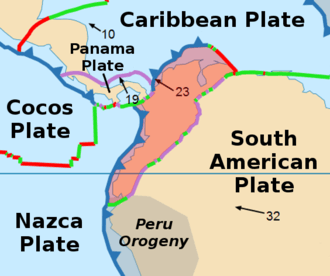
| Plate | North Andean |
| Status | Inactive |
| Type | Oblique thrust fault |
| Movement | Sinistral reverse |
| Age | Quaternary |
| Orogeny | Andean |
The Cimitarra Fault (Spanish: Falla de Cimitarra) is a sinistral oblique thrust fault in the departments of Antioquia, Bolívar and Santander in central Colombia. The fault has a total length of 136.5 kilometres (84.8 mi) and runs along an average northeast to southwest strike of 323 ± 3 in the Middle Magdalena Valley and Central Ranges of the Colombian Andes.
Etymology
The fault is named after the Cimitarra River, Antioquia, a left tributary of the Magdalena River.[1]
Description
The Cimitarra Fault splays from the Palestina Fault in a northeasterly direction on the eastern border of the Central Ranges of the Colombian Andes,[1] passes north of Barrancabermeja,[2] and possibly connects to the Bucaramanga-Santa Marta Fault in the northeast.[3] The fault displaces Jurassic to Cretaceous volcanic rocks, Mesozoic igneous rocks, a Tertiary erosion surface in the Central Ranges, and late Quaternary sediments. Portions of the fault are pre-Pliocene in age, since it is locally covered by undeformed Pliocene sediments. Farther northeast, the fault is overlain by young alluvial deposits of the Middle Magdalena Valley.[1]
The fault is marked by well preserved fault scarps, long straight traces, displaced drainages, and it forms aligned river courses. The slip rate is calculated at 0.1 to 1 millimetre (0.0039 to 0.0394 in) per year.[4]
See also
References
Bibliography
- Paris, Gabriel; Michael N. Machette; Richard L. Dart, and Kathleen M. Haller. 2000a. Map and Database of Quaternary Faults and Folds in Colombia and its Offshore Regions, 1–66. USGS. Accessed 2017-09-18.
Maps
- Gómez, J.; N.E. Montes; Á. Nivia, and H. Diederix. 2015. Plancha 5-06 del Atlas Geológico de Colombia – 1:500,000, 1. Servicio Geológico Colombiano. Accessed 2017-06-06.
- Paris, Gabriel; Michael N. Machette; Richard L. Dart, and Kathleen M. Haller. 2000b. Map of Quaternary Faults and Folds of Colombia and Its Offshore Regions, 1. USGS. Accessed 2017-09-18.
Further reading
- Page, W.D. 1986. Seismic geology and seismicity of Northwestern Colombia, 1–200. San Francisco, California, Woodward-Clyde Consultants Report for ISA and Integral Ltda., Medellín.