Whitesands Bay (Pembrokeshire)
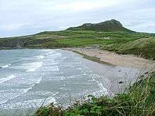
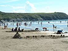
Whitesands Bay (Welsh: Porth Mawr), shown as Whitesand Bay on some maps, is an award-winning, Blue Flag[1] standard, wide sandy beach situated on the St David's Peninsula in the Pembrokeshire Coast National Park, United Kingdom.[2] The beach is located about two miles west of the small city of St. Davids and about one mile south of St Davids Head and has been described as the best surfing beach in Pembrokeshire and one of the best tourist beaches in the world.[3]
The area to the north east of the bay is dominated by a large rocky outcrop, 594 feet (181 m) at its highest point,[4] known as Carn Llidi — which could mean "Cairn of the Gates" or "Cairn of Wrath".[5] The Pembrokeshire Coast Path passes alongside the bay, giving access in the north to the secluded bays of Porthlleuog and Porthmelgan (which are only accessible on foot), and the rugged coastal scenery of St Davids Head. To the south, the coastal path leads to Porthselau and St. Justinian's, with views across the Ramsey Sound to Ramsey Island. There are a number of megalithic burial chambers, stone hut circles and British Iron Age field systems and enclosures to be seen in the vicinity of Carn Llidi and St Davids Head.[6]
There is a tradition that St. Patrick set sail from this beach in 432 AD to convert Ireland to Christianity.[7][8] The site of a Celtic chapel, dedicated to St Patrick, is located under a mound by the car park just to the east of the bay, at what is thought to have been the disembarkation point for pilgrims to St Davids Cathedral.[9] St David, the patron saint of Wales, is said to have been educated at Ty Gwyn (the white farmhouse that overlooks the beach) by St Paulinus. It is believed that St Non, David's mother, also lived here when it was a monastery.
At very low tide and after heavy storms the remains of an ancient, submerged forest can be seen on the beach, consisting of stumps of birch, fir, hazel and oak trees.[10] The remains of animals have also been found in these deposits, including parts of an aurochs, a red deer antler and a brown bear jaw.[11]
Facilities
- Car parks
- Wheelchair access to beach
- Beach shop and cafe
- Lifeguard service (summer months)
- Emergency equipment
- Telephone
- Golf course (9 hole links)
- Youth hostel
- Surf rental
- Camp site
- Toilets
Dogs
Dogs are banned on the beach from 1 May to 30 September by Pembrokeshire Coast National Park.
References
- ↑ Blue flag beaches in Wales Archived 2012-05-01 at the Wayback Machine. Retrieved on 2011-12-18
- ↑ http://www.ukattraction.com/south-wales/whitesands-bay.htm Retrieved on 2008-01-01
- ↑ "Whitesands beach". Visit Pembrokeshire. Pembrokeshire County Council. Retrieved 7 August 2018.
- ↑ http://stdavids.pembrokeshirecoast.org.uk/english/things_to_do/walking.asp Whitesands to Abereiddi Retrieved 2008-01-04 Archived January 6, 2007, at the Wayback Machine.
- ↑ Anon. "Dolmens and cairns:others". Pembrokeshire Virtual Museum. Pembrokeshire County Council. Retrieved 12 January 2010.
- ↑ Map, The Megalithic Portal and Megalith. "Carn Llidi". The Megalithic Portal. Retrieved 2008-01-02.
- ↑ Sommerville, Christopher (18 November 2008). "St David's Head, Wales: Walk of the month". Daily Telegraph. London.
- ↑ "Pembrokeshire Coast Path Walking Holidays with Celtic Trails".
- ↑ http://www.cambria.org.uk/HLC/StDavids/area/area287.htm Retrieved on 2008-01-14
- ↑ Johnson, Lou. "St. David's Head & Carn Llidi - Pembrokeshire Coast Pembrokeshire - Walk 2057 - a walk description from Walking Britain". www.walkingbritain.co.uk. Retrieved 2007-01-09.
- ↑ Anon. "Mesolithic:Submerged Forests". Pembrokeshire Virtual Museum. Pembrokeshire County Council. Retrieved 12 January 2010.
External links
![]()