Smith River National Recreation Area
| Smith River National Recreation Area | |
|---|---|
 | |
 | |
| Location | Del Norte County, California, United States |
| Nearest city | Crescent City, California |
| Coordinates | 41°55′00″N 123°52′00″W / 41.91667°N 123.86667°WCoordinates: 41°55′00″N 123°52′00″W / 41.91667°N 123.86667°W |
| Area | 305,169 acres (1,235 km2) |
| Established | November 16, 1990 |
| Governing body | United States Forest Service |
| Website | Smith River National Recreation Area |
Smith River National Recreation Area is located northwestern California, United States. The Smith River National Recreation Area is in Six Rivers National Forest and is managed by the U.S. Forest Service, an agency of the U.S. Department of Agriculture. Created by Congress in 1990, Smith River National Recreation Area forms a northern border to Redwood National and State Parks.
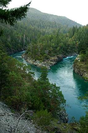
The Coast Ranges and the Smith River, the longest National Wild and Scenic River in the U.S., offer a variety of recreational opportunities. Smith River National Recreation Area has five campgrounds located near major streams and along the Smith River.[1] The recreation area is considered one of the best fishing regions in the U.S. and Rafting is available. Most hiking trails are accessible year-round, but all activities may be greatly affected by heavy rain that swells creeks and rivers.
Climate
The region receives over 90 in (2,300 mm) of rainfall annually, with the greatest amounts in the winter. Summers may be foggy as moisture laden clouds rise up the Coast Range mountains from the Pacific Ocean.
Ecology
Trophy sized steelhead, chinook salmon and other game fish species have led to this area being considered one of the best fishing regions in the United States. Port Orford cedars are native to this area as the tree’s range extends about 50 miles (80 km) inland from the coast around Coos Bay, Oregon, to the mouth of the Mad River near Arcata. To prevent the spread of a root disease caused by the pathogen, Phytophthora lateralis, forest roads and campgrounds may be closed during the rainy season when there is the most opportunities for contaminated soil to be spread around. The spores that live in water and wet soil can be introduced by vehicles, animals and people traveling from infected areas.[2]
Transportation
The area is bisected by U.S. Route 199 which is designated the Smith River Scenic Byway.[1] Passing through the communities of Hiouchi, Gasquet and Patrick Creek on the western side of the summit, the National Forest Scenic Byway is part of the California Freeway and Expressway System[3] and is eligible for the State Scenic Highway System.[4] The highway is the northern portion of the Redwood Highway. Formerly signed as California State Route 199, the highway links U.S. Route 101 near Crescent City, California with Interstate 5 in Grants Pass, Oregon, a distance of 80 miles (130 km).
See also
References
- 1 2 Roberts, Rich (April 10, 1991). "A California Time Capsule : Pristine Version of State Awaits in Smith River Recreation Area". Los Angeles Times. Retrieved 21 May 2016.
- ↑ Soden, Tabitha (October 19, 2015). "Roads in the Six Rivers National Forest close to prevent spread of root disease". Times-Standard. Eureka, CA. Retrieved 8 September 2016.
- ↑ CA Codes (shc:250-257) Archived 2012-10-14 at the Wayback Machine.
- ↑ CA Codes (shc:260-284) Archived 2010-11-03 at the Wayback Machine.
External links
- River Recreation Area - Home "Smith River Recreation Area" Check
|url=value (help). Six Rivers National Forest. U.S.Forest Serviceconifercountry.com. USDA Forest Service. Retrieved 2011-08-27. - "Smith River California". National Wild and Scenic Rivers System. National Park Service. Archived from the original on 2006-05-26. Retrieved 2011-08-27.
- "Carnivorous Plants of the Smith River Region ~ Stoney Creek Trail". conifercountry.com conifercountry.com. Retrieved 2011-08-27.
- Smith River, California - Nation Wild and Scenic River System