Montaña de Oro State Park
| Montaña de Oro State Park | |
|---|---|
 | |
  | |
| Location | San Luis Obispo County, California |
| Nearest city | Los Osos, Morro Bay, San Luis Obispo |
| Coordinates | 35°15′50.04″N 120°51′43.92″W / 35.2639000°N 120.8622000°WCoordinates: 35°15′50.04″N 120°51′43.92″W / 35.2639000°N 120.8622000°W |
| Area | 8,000 acres (32.4 km2) |
| Governing body | California Department of Parks and Recreation |
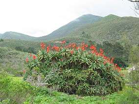
Montaña de Oro ("Mountain of Gold" in Spanish) is a state park in California, United States. The park is located six miles southwest of Morro Bay and 2 miles south of Los Osos. The name "Mountain of Gold" comes from the golden wildflowers found in the park.
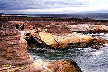
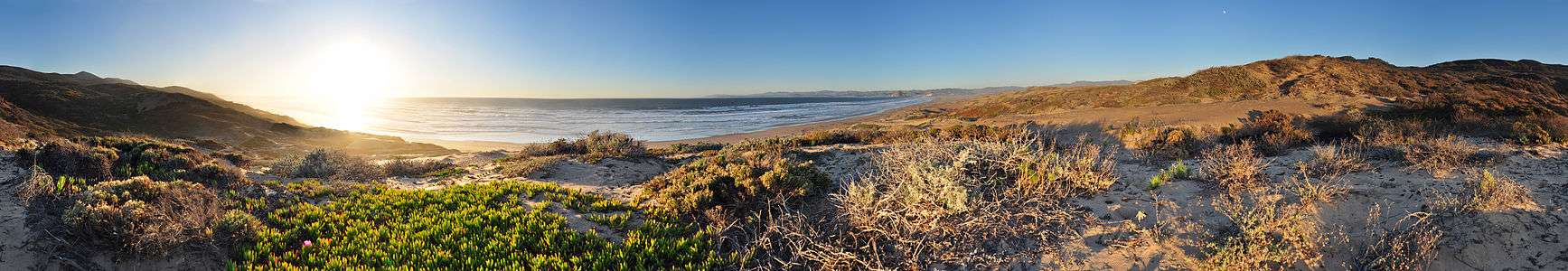
It has 8,000 acres (32 km²) of cliffs, sandy beaches, coastal plains, streams, canyons, and hills, including the 1,347-foot (411 m) Valencia Peak. The park has many hiking, mountain biking, and equestrian trails, as well as a campground located across from Spooner’s Cove, a popular beach. The Bluff Trail is an easy and popular trail along the scenic coast. Trails lead to the summits of Valencia Peak, Oats Peak, and Hazard Peak.[1]
16th-18th century Chumash Indians on California's central coast
Five hundred years ago, when Europeans first arrived on the California's central coast, they found it inhabited by the Chumash Indians. An estimated 20,000 to 30,000 of them lived in small villages spread over a territory which extended from Morro Bay south to Malibu. Although the Chumash depended heavily upon the sea, they also drew on many other sources for food, clothing, and shelter, and were probably part of a large trading network. The Spanish Explorers who visited the Montana de Oro area in 1542 recorded that the Indians were attractive, friendly people who paddled out to greet them in canoes.
In 1769, Don Gaspar de Portola marched his troops north from San Diego to establish new territory for the king of Spain. With the beginning of the Mission period, the Indians were moved inland, and this was the beginning of the end for the Chumash. Most died from European diseases to which they had no immunity. The survivors abandoned their villages and disappeared. With them, their customs, heritage and culture all but vanished as well. Traces of Chumash middens (refuse mounds) and village sites can still be seen in the park, but our knowledge of the Chumash culture remains sketchy. Archaeological advances and further research may help fill in the gaps. For this reason, and so that others may enjoy them, it is against the law to tamper with or disturb any Indian sites.
History after 1842
The property rights for Montaña de Oro State Park land area changed hands several times after California became a territory of the United States. Part of the park was the Rancho Cañada de los Osos that Victor Linares had been granted on December 1, 1842 by Governor Juan B. Alvarado. The rancho lay west of San Luis Obispo in the Los Osos Valley.[2]:Appx,31 Victor Linares sold his rancho to James Scott and John Wilson who also bought the adjacent Rancho Pecho y Islay in the Irish Hills to the south of their Los Osos rancho and combined them in a new 32,431 acre grant, Rancho Cañada de los Osos y Pecho y Islay from Governor Pio Pico in 1845.[2]:Appx,31
It was used mostly for grazing sheep until 1892, when Alden B. Spooner, Jr., leased the land he later purchased around Islay Creek. He brought in dairy cattle, hogs and other agriculture. His two sons founded the Pecho Ranch & Stock Co., and built a ranch house, a complex of barns, a creamery, stables, sheds, and a waterwheel for power. On the south bluff of Spooner's Cove they utilized a warehouse with a long chute that led down to a wharf and a loading boom to service coastal steamers. The land just to the north was owned by Alexander S. Hazard, who also raised crops and maintained a dairy. Hoping to cash in on California's growing need for timber, he planted hundreds of eucalyptus trees, turning Hazard Canyon into a prospective lumber farm. Unfortunately, eucalyptus proved unsatisfactory for commercial use. In the early 1940s, a flood scoured Hazard Canyon, and in 1947 a grass fire burned up the coast from Diablo Canyon, destroying much of what had been the Hazard dairy buildings. However, Hazard's legacy, the stands of eucalyptus trees, remains. Rancher Oliver C. Field bought the land in the early 1940s, but sold it to Irene McAllister about ten years later. In 1965 the property was purchased by the State of California for a state park, and it was decided to keep the name McAllister had given it: "Montaña de Oro".[3]
On April 24, 1965, Rancho Montaña de Oro was dedicated as a California State Park after it was purchased out of the Rancho Montaña de Oro, Inc. bankruptcy proceeding under the Park acquisition program that then Governor Edmund G. "Pat" Brown had launched and managed to fund.
The Rancho Montaña de Oro property was held by Rancho Montaña de Oro, Inc., which was owned by Irene M. Starkey. California Beaches and Parks Director Charles De Turk convinced Morris J. Lavine, the attorney who was involved in the bankruptcy proceedings, to hold the property until the Parks Department could purchase it. Rancho Montaña de Oro, until recently, has had the longest uninterrupted, preserved and undeveloped coastal area of any publicly owned land in California.
Marine protected areas
Morro Bay State Marine Recreational Management Area and Morro Bay State Marine Reserve and Point Buchon State Marine Reserve and Marine Conservation Area are marine protected areas offshore from the Morro Bay area. Like underwater parks, these marine protected areas help conserve ocean wildlife and marine ecosystems.
See also
References
- ↑ "Trails in Montaña de Oro State Park". hikespeak.com. Hikespeak San Luis Obispo. Retrieved May 11, 2017.
- 1 2 Ogden Hoffman, 1862, Reports of Land Cases Determined in the United States District Court for the Northern District of California, Numa Hubert, San Francisco.
- ↑ Sierra Club
External links
| Wikimedia Commons has media related to Montana de Oro State Park. |