Trinidad State Beach
| Trinidad State Beach | |
|---|---|
 | |
  | |
| Location | Humboldt County, California |
| Nearest city | Trinidad |
| Coordinates | 41°4′0″N 124°9′0″W / 41.06667°N 124.15000°W / 41.06667; -124.15000Coordinates: 41°4′0″N 124°9′0″W / 41.06667°N 124.15000°W / 41.06667; -124.15000 |
| Governing body | California Department of Parks and Recreation |
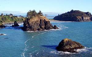
Trinidad State Beach is 20 miles (30 km) north of Eureka in Humboldt County, California. This scenic state beach is accessed from a signposted side road at Trinity Street and Stagecoach Road in the seaside town of Trinidad. The parking lot at Trinidad Bay below Trinidad Head is another popular access point.[1][2] The offshore rocks are part of the California Coastal National Monument. Colorful tide pools provide specimens to Humboldt State University's Fred Telonicher Marine Laboratory located in Trinidad.
Nearby parks include Little River State Beach just south of Trinidad and to the north, Patrick's Point State Park. The Beach's latitude and longitude are 41.0594 / -124.1420.[3]
See also
- List of beaches in California
- List of California state parks
- Parks in Humboldt County, California
References
- ↑ Strickland, Tonya (September 18, 2015). "Bill would add Piedras Blancas Light Station to California Coastal National Monument". The Tribune (San Luis Obispo).
- ↑ Clark, Samantha (September 18, 2015). "Bill would include Coast Dairies in California Coastal National Monument". Santa Cruz Sentinel.
- ↑ "Trinidad SB." California State Parks. Accessed July 2011.
External links
| Wikimedia Commons has media related to Trinidad State Beach. |
- Trailmaster, Inc (2007–2008). "Trinidad State Beach Park Info". California State Parks. Retrieved 2008-10-30. Archived by WebCite at https://www.webcitation.org/5bxpohNWL)
- Trinidad State Beach - HCCVB
- "California Coastal National Monument". U.S. Bureau of Land Management. Retrieved 2008-10-30.
- Image of the State Beach
This article is issued from
Wikipedia.
The text is licensed under Creative Commons - Attribution - Sharealike.
Additional terms may apply for the media files.