Ventana Wilderness
| Ventana Wilderness | |
|---|---|
|
IUCN category Ib (wilderness area) | |
 | |
| Location | Los Padres National Forest, Monterey County, California, United States |
| Nearest city | Monterey, California |
| Coordinates | 36°15′0″N 121°40′0″W / 36.25000°N 121.66667°WCoordinates: 36°15′0″N 121°40′0″W / 36.25000°N 121.66667°W |
| Area | 240,026 acres (97,135 ha) |
| Established | August 18, 1969 |
| Governing body | U.S. Forest Service / Bureau of Land Management |
The Ventana Wilderness of Los Padres National Forest is a federally designated wilderness area located in the Santa Lucia Range along the Central Coast of California. This wilderness was established in 1969 when the Ventana Wilderness Act redesignated the 55,800-acre (22,600 ha) Ventana Primitive Area as the Ventana Wilderness and added land, totalling 98,000-acre (40,000 ha). In 1978, the Endangered American Wilderness Act added 61,000 acres (25,000 ha), increasing the total wilderness area to about 159,000 acres (64,000 ha). The California Wilderness Act of 1984 added about 2,750 acres (1,113 ha). The Los Padres Condor Range and River Protection Act of 1992 created the approximately 14,500-acre (5,900 ha) Silver Peak Wilderness and added about 38,800 acres (15,700 ha) to the Ventana Wilderness in addition to designating the Big Sur River as a Wild and Scenic River. Most recently, the Big Sur Wilderness and Conservation Act of 2002 expanded the wilderness for the fifth time, adding nearly 35,000 acres (14,000 ha), increasing the total acreage of the wilderness to its present size of 240,026 acres (97,135 ha).[1]
Name origin
The Ventana Wilderness is named for the unique notch called "The Window" (ventana in Spanish) on a ridge near Ventana Double Cone. According to local legend, this notch was once a natural stone arch.[2]
History
Native America use
Three tribes of Native Americans — the Ohlone, Esselen, and Salinan — are believed to have been the first people to inhabit the area. The Ohlone, also known as the Costanoans, are believed to have lived in the region from San Francisco to Point Sur. The Esselen lived in the area between Point Sur south to Big Creek, and inland, including the upper tributaries of the Carmel River and Arroyo Seco watersheds. The Salinan lived from Big Creek south to San Carpóforo Creek.[3] Archaeological evidence shows that the Esselen lived in Big Sur as early as 3500 BC, leading a nomadic, hunter-gatherer existence.[4][5]
The indigenous people lived near the coast in winter, where they harvested rich stocks of mussels, abalone and other sea life. In the summer and fall they moved inland to harvest acorns gathered from the black oak, canyon live oak and tanbark oak, primarily on upper slopes in areas on the upper slopes of the steep canyons.[6]:270
Founding and additions
U.S. Forest Service Chief Forester R. Y. Stuart ordered the Monterey Ranger District to establish the Ventana Primitive Area. It originally consisted of 45,520 acres (18,421 ha) and was enlarged in 1937 to about 55,884 acres (22,615 ha). When the U.S. Congress passed the Wilderness Act of 1964, the Ventana Primitive Area was formally designated as wilderness by law, rather than by a Forest Service regulation, which made the area's status subject to change at will. The Ventana Wilderness Area was formally established on August 18, 1969. The Ventana initially included 164,554 acres (66,593 ha) acres of primarily extremely rugged terrain within the Santa Lucia Range of the Monterey Ranger District.[7]
In 1978, the Endangered American Wilderness Act added 61,000 acres (25,000 ha), increasing the total wilderness area to about 159,000 acres (64,000 ha). The California Wilderness Act of 1984 added about 2,750 acres (1,113 ha). In 1992, the Los Padres Condor Range and River Protection Act created the approximately 14,500-acre (5,900 ha) Silver Peak Wilderness and added about 38,800 acres (15,700 ha) to the Ventana Wilderness. In 2002, the Big Sur Wilderness and Conservation Act added nearly 35,000 acres (14,000 ha), increasing the total acreage of the wilderness to its present size of 240,026 acres (97,135 ha).[1] A very small part, 736 acres (298 ha), on the eastern edge of the wilderness is managed by the Bureau of Land Management.[8]

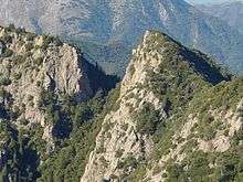
Topography
The topography of the Ventana Wilderness is characterized by steep-sided, sharp-crested ridges separating V-shaped youthful valleys. Most streams fall rapidly through narrow, vertical-walled canyons over bedrock or a veneer of boulders. Waterfalls, deep pools and thermal springs are found along major streams. Elevations range from 600 feet (180 m), where the Big Sur River leaves the Wilderness, to about 5,750 feet (1,750 m) at the wilderness boundary near Junipero Serra Peak.
Geologic features
Pico Blanco, which splits the north and south forks of the Little Sur River, was sacred in the native traditions of the Rumsien and the Esselen, who revered the mountain as a sacred place from which all life originated.[9] The Spanish mission system led to the virtual destruction of the Indian population. Estimates for the pre-contact populations of most native groups in California have varied substantially. Alfred L. Kroeber suggests a 1770 population for the Esselen of 500.[10] Sherburne F. Cook raises this estimate to 750.[11] A more recent calculation (based on baptism records and density) is that they numbered 1,185-1,285.[12]
Flora and fauna
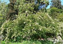
Marked vegetation changes occur within the Wilderness, attributable to dramatic climatic and topographic variations coupled with an extensive fire history. Much of the Ventana Wilderness is covered by dense communities of chaparral, a group of fire-prone plant species, consisting largely of chamise and various species of manzanita and ceanothus. Other plant communities found in area include oak woodland (coast live oak, valley oak, etc.) and pine woodlands (Coulter pine and Knobcone pine). Poison oak is found throughout the area. Deep narrow canyons cut by the fast moving Big Sur and Little Sur rivers support stands of coastal redwood (some old-growth forest), big leaf maple, and sycamore. Small scattered stands of the rare, endemic bristlecone fir may be found on rocky slopes and canyon bottoms. Mountain lion, bobcat, bear, deer, fox and coyotes range the wilderness, as does the California condor, reintroduced to the region by the Ventana Wildlife Society.[13]
Wilderness access
During the 1930s, the United States Civilian Conservation Corps constructed an extensive network of trails and trailheads that provided access to the Wilderness. A number of these are no longer in use.[7] The Pine Ridge trailhead at Big Sur Station near Pfeiffer Big Sur State Park is by far the most popular starting point.[14] As of August 2017, the trail was blocked by multiple washouts along creeks and dozens of fallen trees across the path. Reopening the trail will require an environmental assessment and perhaps re-routing the trail entirely. The trail is closed indefinitely.[15]
Other trailheads include Bottchers Gap, Los Padres Dam, China Camp, and Arroyo Seco. Much of the area is very rugged and trails within the Wilderness are frequently overgrown and challenging to follow. Off-trail travel can be extremely difficult due to the steep, unstable terrain, and dense vegetation, like Pacific madrone, manzanita, and ceanothus. As is the case in most designated Wilderness areas, motorized equipment and mechanized transport are not allowed. Hunting of feral pigs (Sus scrofa) or European boar, which were introduced into the Carmel Valley area in 1927,[16] is permitted by license.
Government
At the county level, the Ventana Wilderness area is represented on the Monterey County Board of Supervisors by Supervisor Dave Potter.[17]
In the California State Legislature, the Ventana Wilderness is in the 17th Senate District, represented by Democrat Bill Monning, and in the 30th Assembly District, represented by Democrat Anna Caballero.[18] In the United States House of Representatives, the Ventana Wilderness is in California's 20th congressional district, represented by Democrat Jimmy Panetta.[19]
References
- 1 2 "A Brief Land Status History of the Monterey Ranger District". Double Cone Quarterly (Fall 2002 ed.). Ventana Wilderness Society. Retrieved June 22, 2010.
- ↑ "Hiking in Big Sur". Big Sur Chamber of Commerce. Retrieved April 30, 2009.
- ↑ "Cultural History". Ventana Inn. Retrieved August 23, 2016.
- ↑ Analise, Elliott (2005). Hiking & Backpacking Big Sur. Berkeley, California: Wilderness Press. p. 21.
- ↑ Pavlik, Robert C. (November 1996). "Historic Resource Evaluation Report on the Rock Retaining Walls, Parapets, Culvert Headwalls and Drinking Fountains along the Carmel to San Simeon Highway" (PDF). California Department of Transportation. Retrieved August 23, 2016.
- ↑ Henson, Paul (1993). The Natural History of Big Sur (PDF). Donald J. Usner. Berkeley: University of California Press. ISBN 0-520-20510-3. Archived from the original on 2010-06-17. Retrieved 2009-11-22.
- 1 2 Blakely, Jim; Barnette, Karen (July 1985). Historical Overview: Los Padres National Forest (PDF).
- ↑ "Ventana Wilderness". Bureau Of Land Management. Retrieved 7 September 2016.
- ↑ Elliot, Analise (January 2005). Hiking & Backpacking Big Sur: A Complete Guide to the Trails of Big Sur. Wilderness Press. p. 323. ISBN 0-89997-326-4.
- ↑ Kroeber, p.883
- ↑ Cook, p.186
- ↑ Breschini & Haversat
- ↑ Wright, Tommy (September 1, 2016). "Soberanes Fire could be beneficial for condors". The Monterey County Herald. Retrieved 4 September 2016.
- ↑ Wilderness.net
- ↑ Schmalz, David. "Many Big Sur trails have been closed for a year. Work to repair them has barely begun". Monterey County Weekly. Retrieved 2018-01-09.
- ↑ "Ventana Wilderness Alliance Hunting And Fishing Policy". Ventana Wilderness Society. 27 May 2004. Retrieved 2009-11-01.
- ↑ "Monterey County Supervisorial District 5 Map (North District 5)" (PDF). County of Monterey. Archived from the original (PDF) on 1 July 2012. Retrieved 21 September 2012.
- ↑ "Statewide Database". UC Regents. Retrieved February 2, 2015.
- ↑ "California's 20th Congressional District - Representatives & District Map". Civic Impulse, LLC.