Limekiln State Park
| Limekiln State Park | |
|---|---|
|
IUCN category III (natural monument or feature) | |
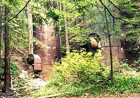 Two of the limekilns for which the park is named | |
  | |
| Location | Monterey County, California, USA |
| Nearest city | Big Sur, California |
| Coordinates | 36°0′36″N 121°31′6″W / 36.01000°N 121.51833°WCoordinates: 36°0′36″N 121°31′6″W / 36.01000°N 121.51833°W |
| Area | 711 acres (288 ha) |
| Established | 1994 |
| Governing body | California Department of Parks and Recreation |
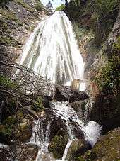
Limekiln State Park is a state park of California, United States, on the Big Sur coast. It contains four lime kilns from an 1887–1890 lime-calcining operation, plus a beach, redwood forest, and 100-foot (30 m) Limekiln Falls.[1] It is located 2 miles (3.2 km) south of Lucia on State Route 1. The 711-acre (288 ha) park was established in 1994.[2]
Cultural history
From 1887 to 1890 the Rockland Lime and Lumber Company harvested limestone from a scree slope and fed it into four iron and stone lime kilns they erected onsite. Long exposure to very hot fires extracted lime.[1] Barrels of lime were slid on a cable out to Rockland Cove, where they were loaded onto ships. The lime was a key ingredient in the cement that was used for construction in San Francisco and Monterey.[3] However after three years the company had exhausted most of the limestone as well as the redwood used to fire the kilns. Today an easy .5-mile (0.80 km) trail leads to the lime smelting ruins, which include four kilns and some stone walls and bridge abutments.[1]
The redwood forest recovered from this industrial use, but in 1984 a private landowner planned to log the west fork of Limekiln Creek. Conservationists objected and succeeded in getting the land preserved as a public park.[3] The campground was family-owned before it was then sold and operated by the Esalen Institute for a number of years. The property was transferred to the California state park system and opened in September 1995.[3]
Limekiln State Park was heavily damaged in the Chalk Fire of September and October 2008. In total the Chalk Fire burned 16,269 acres (65.84 km2) in California.[4] Due to the damage the park was closed, not reopening until July 2, 2010. At that time the Limekiln Falls Trail remained closed, but reopened in summer 2011. The Hare Creek Trail is shorter due to damage related to the Chalk Fire.
Proposed for closure
Limekiln State Park was one of many state parks threatened with closure in 2008. Those closures were ultimately avoided by cutting hours and maintenance system-wide.[5] The park was again threatened with closure, along with 70 other California state parks in July 2012 as part of a deficit reduction program.[6] A partner organization has signed an agreement to keep the park open.[7]
Recreation
Limekiln State Park has a small but popular campground with 31 sites among the redwoods and 11 sites with an ocean view. Easy trails lead to the lime kilns or up Hare Creek Canyon. Another leads to Limekiln Falls on the east fork of Limekiln Creek.[1]
Government
At the county level, Limekiln State Park is represented on the Monterey County Board of Supervisors by Supervisor Dave Potter.[8]
In the California State Legislature, Limekiln State Park is in the 17th Senate District, represented by Democrat Bill Monning, and in the 30th Assembly District, represented by Democrat Anna Caballero.[9]
In the United States House of Representatives, Limekiln State Park is in California's 20th congressional district, represented by Democrat Jimmy Panetta.[10]
See also
References
- 1 2 3 4 "Limekiln State Park" (PDF). California State Parks. 2008. Archived from the original (PDF) on 2011-09-30. Retrieved 2012-07-29.
- ↑ "California State Park System Statistical Report: Fiscal Year 2009/10" (PDF). California State Parks: 30. Retrieved 2012-07-29.
- 1 2 3 McKinney, Jim. "Limekiln Trail". Day Hiker’s Guide to California’s State Parks. The Trailmaster Inc. Retrieved 2012-07-29.
- ↑ "InciWeb: Chalk Fire". InciWeb Incident Information System. 2008-10-30. Archived from the original on 2012-02-16. Retrieved 2012-07-29.
- ↑ McGreevy, Patrick; Louis Sahagun (2009-09-26). "State parks to stay open, but with cuts in hours, staffing". Los Angeles Times. Los Angeles, Calif. Retrieved 2011-12-30.
- ↑ "State Parks Announces Closures" (PDF) (Press release). California State Parks. 2011-05-13. Retrieved 2011-09-24.
- ↑ "Your Town: Local state parks get reprieve from closure". The Monterey County Herald. Monterey, Calif. 2012-07-03. Retrieved 2012-07-29.
- ↑ "Monterey County Supervisorial District 5 Map (North District 5)" (PDF). County of Monterey. Archived from the original (PDF) on 1 July 2012. Retrieved 21 September 2012.
- ↑ "Statewide Database". UC Regents. Retrieved February 2, 2015.
- ↑ "California's 20th Congressional District - Representatives & District Map". Civic Impulse, LLC.