San Bruno Mountain State Park
| San Bruno Mountain State Park | |
|---|---|
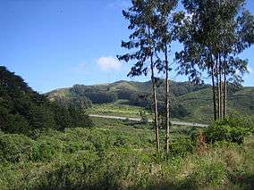 View of San Bruno Mountain from the park | |
  | |
| Location | San Mateo County, California, USA |
| Coordinates | 37°41′8″N 122°25′47″W / 37.68556°N 122.42972°WCoordinates: 37°41′8″N 122°25′47″W / 37.68556°N 122.42972°W |
| Governing body | California Department of Parks and Recreation |
San Bruno Mountain State Park is a state park located in northern San Mateo County, California. It is adjacent to the southern boundary of San Francisco and borders the cities of Brisbane, South San Francisco, Colma and Daly City.
San Bruno Mountain Park is a landmark of local and regional significance, standing as a unique open-space island in the midst of the peninsula's urbanization at the northern end of the Santa Cruz Mountain Range. The park is dominated by San Bruno Mountain which is a 4-mile (6.4 km) ridge. The park provides habitat for several species of rare and endangered plants and butterflies, including the Mission blue butterfly. Trails to the summit afford outstanding views of San Francisco and the Bay Area.

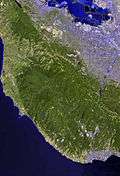
A view of San Francisco from the park
See also
- List of California state parks
- Parks in San Mateo County, California
External links

- San Bruno Mountain Watch Private advocacy group for the park
- "San Bruno Mountain State & County Park". County of San Mateo Parks Department. Retrieved 22 June 2016.
- Topographic Map
- "San Bruno Mountain State Park". California Department of Parks and Recreation. Retrieved 22 June 2016.
- Trailspotting: Hiking the San Bruno Mountain Summit Loop Trail Description, Photos and GPS/mapping data
This article is issued from
Wikipedia.
The text is licensed under Creative Commons - Attribution - Sharealike.
Additional terms may apply for the media files.