Sillé-le-Guillaume
| Sillé-le-Guillaume | ||
|---|---|---|
| Commune | ||
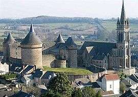 The château and the church of Notre-Dame | ||
| ||
 Sillé-le-Guillaume Location within Pays de la Loire region  Sillé-le-Guillaume | ||
| Coordinates: 48°11′03″N 0°07′41″W / 48.1842°N 0.1281°WCoordinates: 48°11′03″N 0°07′41″W / 48.1842°N 0.1281°W | ||
| Country | France | |
| Region | Pays de la Loire | |
| Department | Sarthe | |
| Arrondissement | Mamers | |
| Canton | Sillé-le-Guillaume (chef-lieu) | |
| Intercommunality | Communauté de communes du Pays de Sillé | |
| Government | ||
| • Mayor (2008–2014) | Jean-Marie Hoguet | |
| Area1 | 12.90 km2 (4.98 sq mi) | |
| Population (2006)2 | 2,360 | |
| • Density | 180/km2 (470/sq mi) | |
| Demonym(s) | Silléens | |
| Time zone | UTC+1 (CET) | |
| • Summer (DST) | UTC+2 (CEST) | |
| INSEE/Postal code | 72334 /72140 | |
| Elevation | 115–260 m (377–853 ft) | |
| Website | www.sille-le-guillaume.fr | |
|
1 French Land Register data, which excludes lakes, ponds, glaciers > 1 km2 (0.386 sq mi or 247 acres) and river estuaries. 2 Population without double counting: residents of multiple communes (e.g., students and military personnel) only counted once. | ||
.svg.png)
Sillé-le-Guillaume is a commune in the Sarthe department in the region of Pays-de-la-Loire in north-western France, named after Guillaume de Sillé.
In the fifteenth century the lord of the manor was Sir John Fastolf of Caister in Norfolk (1380–1459), following the English conquest of Normandy and Maine.
See also
References
- Bibliography
- Barker, Juliet. Conquest: The English Kingdom of France 1417–1450. London: Little, Brown.
- Cooper, Stephen (2010). The Real Falstaff, Sir John Fastolf and the Hundred Years War. Barnsley: Pen and Sword.
External links
| Wikimedia Commons has media related to Sillé-le-Guillaume. |
This article is issued from
Wikipedia.
The text is licensed under Creative Commons - Attribution - Sharealike.
Additional terms may apply for the media files.