Shizukuishi, Iwate
| Shizukushi 雫石町 | |||
|---|---|---|---|
| Town | |||
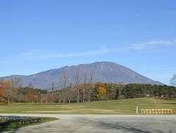 View of Mount Iwate from Koiwai farm park | |||
| |||
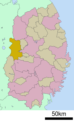 Location of Shizukuishi in Iwate Prefecture | |||
 Shizukushi | |||
| Coordinates: 39°41′42.7″N 140°58′32.8″E / 39.695194°N 140.975778°ECoordinates: 39°41′42.7″N 140°58′32.8″E / 39.695194°N 140.975778°E | |||
| Country | Japan | ||
| Region | Tōhoku | ||
| Prefecture | Iwate | ||
| District | Iwate | ||
| Government | |||
| • -Mayor | Masamitsu Fukaya (since October 2010) | ||
| Area | |||
| • Total | 608.82 km2 (235.07 sq mi) | ||
| Population (October 2016) | |||
| • Total | 16,704 | ||
| • Density | 27.4/km2 (71/sq mi) | ||
| Time zone | UTC+9 (Japan Standard Time) | ||
| - Tree | Sugi | ||
| - Flower | Chrysanthemum | ||
| - Bird | Uguisu | ||
| Phone number | 019-692-2111 | ||
| Address | 5-1 Senkarita, Shizukuishi-chō, Iwate-gun, Iwate-ken 029-0595 | ||
| Website | http://www.town.shizukuishi.iwate.jp/ | ||


Shizukuishi (雫石町 Shizukuishi-chō) is a town located in Iwate Prefecture, Japan. As of 1 October 2016, the town had an estimated population of 16,704, and a population density of 27.4 persons per km². The total area of the town is 608.82 square kilometres (235.07 sq mi).
Geography
Shizukuishi is located in the Ōu Mountains of west-central Iwate Prefecture, bordering Akita Prefecture to the west. Mount Iwate (2038 m), an active volcano, lies just to the north of Shizukuishi and dominates the landscape. The Ōu Mountains form the boundary to the west as well with Akita Komagatake, another active volcano, just across the border in Akita Prefecture. The downtown area is located where the Shizukuishi and Kakkonda Rivers meet. Gosho Lake was created in 1981 with the completion of Gosho Dam.
Neighboring municipalities
Climate
Shizukuishi has a cold humid continental climate (Köppen Dfa) characterized by mild summers and cold winters with heavy snowfall. The average annual temperature in Shizukuishi is 9.2 °C. The average annual rainfall is 1469 mm with September as the wettest month and February as the driest month. The temperatures are highest on average in August, at around 23.2 °C, and lowest in January, at around -3.7 °C.[1]
| Climate data for Shizukuishi (altitude 195m) | |||||||||||||
|---|---|---|---|---|---|---|---|---|---|---|---|---|---|
| Month | Jan | Feb | Mar | Apr | May | Jun | Jul | Aug | Sep | Oct | Nov | Dec | Year |
| Record high °C (°F) | 11.9 (53.4) |
12.7 (54.9) |
19.4 (66.9) |
28.5 (83.3) |
31.8 (89.2) |
32.6 (90.7) |
35.1 (95.2) |
35.8 (96.4) |
32.9 (91.2) |
27.0 (80.6) |
21.4 (70.5) |
14.7 (58.5) |
35.8 (96.4) |
| Average high °C (°F) | 0.8 (33.4) |
1.7 (35.1) |
5.6 (42.1) |
13.5 (56.3) |
19.1 (66.4) |
23.0 (73.4) |
25.9 (78.6) |
27.7 (81.9) |
23.2 (73.8) |
17.1 (62.8) |
10.0 (50) |
3.7 (38.7) |
14.3 (57.7) |
| Daily mean °C (°F) | −2.9 (26.8) |
−2.3 (27.9) |
1.1 (34) |
7.7 (45.9) |
13.3 (55.9) |
17.8 (64) |
21.3 (70.3) |
22.6 (72.7) |
17.9 (64.2) |
11.2 (52.2) |
5.0 (41) |
0.1 (32.2) |
9.4 (48.9) |
| Average low °C (°F) | −7.3 (18.9) |
−6.9 (19.6) |
−3.4 (25.9) |
1.9 (35.4) |
7.5 (45.5) |
13.2 (55.8) |
17.4 (63.3) |
18.5 (65.3) |
13.4 (56.1) |
5.9 (42.6) |
0.4 (32.7) |
−3.6 (25.5) |
4.8 (40.6) |
| Record low °C (°F) | −20.6 (−5.1) |
−20.3 (−4.5) |
−15.7 (3.7) |
−9.6 (14.7) |
−1.5 (29.3) |
3.6 (38.5) |
7.6 (45.7) |
8.7 (47.7) |
1.4 (34.5) |
−4.4 (24.1) |
−10.4 (13.3) |
−18.2 (−0.8) |
−20.6 (−5.1) |
| Average precipitation mm (inches) | 69.6 (2.74) |
64.2 (2.528) |
92.8 (3.654) |
108.7 (4.28) |
120.0 (4.724) |
132.5 (5.217) |
230.7 (9.083) |
206.4 (8.126) |
184.9 (7.28) |
115.8 (4.559) |
120.0 (4.724) |
99.6 (3.921) |
1,545.2 (60.836) |
| Average snowfall cm (inches) | 165 (65) |
132 (52) |
91 (35.8) |
5 (2) |
0 (0) |
0 (0) |
0 (0) |
0 (0) |
0 (0) |
0 (0) |
12 (4.7) |
95 (37.4) |
499 (196.5) |
| Mean monthly sunshine hours | 84.5 | 104.3 | 137.2 | 168.6 | 185.5 | 163.2 | 134.0 | 141.1 | 114.9 | 129.4 | 100.5 | 77.7 | 1,547.5 |
| Source: Japan Meteorological Agency [2] | |||||||||||||
Demographics
Per Japanese census data,[3] the population of Shizukuishi peaked around the year 2000, but has declined since then.
| Census Year | Population |
|---|---|
| 1970 | 17,954 |
| 1980 | 18,696 |
| 1990 | 19,013 |
| 2000 | 19,750 |
| 2010 | 18,038 |
History
The area of present-day Shizukuishi has been inhabited since the earliest times. Archaeologists have found remains dating to the Japanese Paleolithic period. The area come under the control of the Yamato dynasty during the early Heian period under the campaigns of Sakanoue no Tamuramaro, and was part of ancient Mutsu Province. The area was a battlefield during the Former Nine Years War and the Gosannen War. It eventually came under the control of the Nambu clan, who ruled from Morioka Domain under the Edo period Tokugawa shogunate.
In the Meiji period, the villages of Shizukuishi, Gosho, Nishiyama and Omyojin within Minami-Iwate District were created on April 1, 1889, with the establishment of the modern municipalities system. Kita-Iwate District and Minami-Iwate Districts merged to form Iwate District on March 29, 1896. Shizukuishi was raised to town status on December 23, 1940. On April 1, 1955, Shizukuishi merged with Gosho, Nishiyama and Omyojin, but lost a portion of its territory in a border adjustment with Morioka City on October 1 of the same year. The All Nippon Airways Flight 58 accident occurred over Shizukuishi on July 30, 1971.
Economy
The local economy is based on agriculture, forestry and seasonal tourism. Koiwai Farm, based in Takizawa, is currently the largest privately owned dairy production center in Japan. The farm produces a full range of dairy products distributed throughout the nation.[4]
Education
Shizukuishi has ten public elementary schools and one middle schools operated by the town government, and one public high school operated by the Iwate Prefectural Board of Education.
Transportation
Railway
- East Japan Railway Company (JR East) – Akita Shinkansen
- East Japan Railway Company (JR East) – Tazawako Line
Highway
Local attractions
- In winter, numerous ski resorts come to life. Due to the town's rural nature, low income and low population Yoshiaki Tsutsumi, Japan's richest man at the time, was able to build a large ski area and hotel without the kind of "organized opposition of environmentalists" which stymied his plans elsewhere in Japan.[5][5]
- Koiwai Farm is a working dairy and tourist attraction. A number of the farm buildings have been named National Tangible Cultural Properties. The farm has been used as a shooting location for television dramas and movies.[6] Every year Koiwai Farm puts on the Koiwai Snow Festival (小岩井雪祭 Koiwai Yuki Matsuri). This festival is noteworthy for its giant snow sculptures.
- The town is known for its annual hemp festival every year in August which draws "crowds of sightseers".[7]
References
- ↑ Shizukuishi climate data
- ↑ "雫石 19801-2010年". Japan Meteorological Agency. Retrieved 2011-10-18.
- ↑ Shizukuishi population statistics
- ↑ Koiwai's official website (in Japanese)
- 1 2 "Japanese tycoon building top-notch ski, golf resort", The Chicago Daily Herald, August 25, 1991, section 4, page 2
- ↑ "Koiwai Farm ( Shizukuishi Town )". A Trip to Iwate. Iwate Prefecture Tourism Portal. Retrieved 28 March 2017.
- ↑ "Legal hemp in Shizuoka, bizarre drug laws" Reuters Newswire, August 25, 1998 Retrieved 31 August 2010.
External links
![]()
- Official Website (in Japanese)