Shizukuishi River
| Shizukuishi River | |
|---|---|
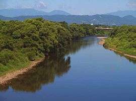 Shizukuishi River looking northeast from the Morioka Chuo Bridge | |
| Native name | 雫石川 |
| Country | Japan |
| Physical characteristics | |
| Main source |
Mount Akita-Komagatake 1,637 m (5,371 ft) |
| River mouth |
Kitakami River 39°41′40″N 141°08′40″E / 39.69444°N 141.14444°ECoordinates: 39°41′40″N 141°08′40″E / 39.69444°N 141.14444°E |
| Length | 33.2 km (20.6 mi) |
| Basin features | |
| Basin size | 168 km2 (65 sq mi) |

Shizukuishi and Kakkonda Rivers with the Gosho Dam and Reservoir
The Shizukuishi River (雫石川 Shizukuishigawa) is a river in Iwate Prefecture, in the Tōhoku region of northern Honshū in Japan. The river is 33.2 kilometres (20.6 mi) long and has a watershed of 168 square kilometres (65 sq mi).
The Shizukuishi River rises in the Ōu Mountains just south of Mount Akita-Komagatake in the town of Shizukuishi and empties into the Kitakami River in the city of Morioka. The Gosho Dam is situated on the Shizukuishi River in western Morioka. This dam was completed in 1981. The entire length of the river is home to many renowned hot springs.
External links
![]()
| |||||||||||||||||
| |||||||||||||||||
| |||||||||||||||||
| |||||||||||||||||
| |||||||||||||||||
This article is issued from
Wikipedia.
The text is licensed under Creative Commons - Attribution - Sharealike.
Additional terms may apply for the media files.