Sumita, Iwate
| Sumita 住田町 | |||
|---|---|---|---|
| Town | |||
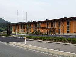 Sumita Town Hall | |||
| |||
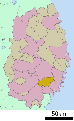 Location of Sumita in Iwate Prefecture | |||
 Sumita Location of Sumita in Iwate Prefecture | |||
| Coordinates: 39°08′32″N 141°34′30″E / 39.14222°N 141.57500°ECoordinates: 39°08′32″N 141°34′30″E / 39.14222°N 141.57500°E | |||
| Country | Japan | ||
| Region | Tōhoku | ||
| Prefecture | Iwate | ||
| District | Kesen | ||
| Government | |||
| • Mayor | Ken'ichi Kanda | ||
| Area | |||
| • Total | 334.84 km2 (129.28 sq mi) | ||
| Population (May 1 2017) | |||
| • Total | 5,733 | ||
| • Density | 17/km2 (40/sq mi) | ||
| Population total figure is for total residents, including resident aliens | |||
| Time zone | UTC+9 (Japan Standard Time) | ||
| City symbols | |||
| • Tree | Cryptomeria | ||
| • Flower | Large-flowered cypripedium | ||
| • Bird | Copper pheasant | ||
| Phone number | 0192-46-2111 | ||
| Address | Setamai, Kawamukai 88-1, Sumita-cho, Kensen-gun, Iwate-ken 029-2396 | ||
| Website | http://www.town.sumita.iwate.jp/ | ||


Sumita (住田町 Sumita-chō) is a town located in Iwate Prefecture, Japan. As of 1 April 2017, the town had an estimated population of 5,733, and a population density of 17 persons per km2 in 2218 households.[1] The total area of the town is 334.84 square kilometres (129.28 sq mi).[2]
Geography
Sumita is located in a basin in southeastern Iwate Prefecture in the southern Kitakami Mountains, surrounded by peaks with an elevation of between 600 and 1500 meters an all sides. Approximately 90% of the town’s area is covered by forest and mountains. Sumita has a humid climate (Köppen climate classification Dfa) with warm summers and cold winters. The average annual temperature in Sumita is 10.4 °C. The average annual rainfall is 1379 mm with September as the wettest month and January as the driest month. The temperatures are highest on average in August, at around 23.1 °C, and lowest in January, at around -1.2 °C.[3]
Neighboring municipalities
- Iwate Prefecture
Demographics
Per Japanese census data,[4] the population of Sumita has declined over the past 40 years.
| Census Year | Population |
|---|---|
| 1970 | 10,397 |
| 1980 | 9,036 |
| 1990 | 8,228 |
| 2000 | 7,305 |
| 2010 | 6,190 |
History
The area of present-day Sumita was part of ancient Mutsu Province. It was under the control of the Date clan during the Edo period, who ruled the Sendai Domain under the Tokugawa shogunate.
The villages of Kamiarisu, Shimoarisu and Setamai within Kesen District were created on April 1, 1889, with the establishment of the modern municipalities system. Setamai became a town on April 29, 1940. Kamiarisu and Shimoarisu merged with Setamai on April 1, 1955 to create the town of Sumita.
Economy
The local economy consists largely of forestry and agriculture, with pig farming contributing to over half of the town's agricultural production.[2]
Education
Sumita has two public elementary schools and two public middle schools operated by the local board of education. There is one public high school operated by the Iwate Prefectural Board of Education.
Transportation
Railway
- East Japan Railway Company (JR East) – Kamaishi Line
Highway
References
- ↑ Sumita official town home page (in Japanese)
- 1 2 "詳細データ 岩手県紫波町". 市町村の姿 グラフと統計でみる農林水産業 (in Japanese). Ministry of Agriculture, Forestry and Fisheries. 2016. Retrieved 13 April 2017.
- ↑ Sumita climate data
- ↑ Sumita population statistics
External links
![]()
- Official Website (in Japanese)