Santa Luzia, Cape Verde
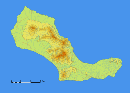 Terrain map of Santa Luzia | |
 | |
| Geography | |
|---|---|
| Location | Atlantic Ocean |
| Coordinates | 16°45′41″N 24°44′38″W / 16.76139°N 24.74389°WCoordinates: 16°45′41″N 24°44′38″W / 16.76139°N 24.74389°W |
| Archipelago | Cape Verde |
| Area | 34.2 km2 (13.2 sq mi) |
| Length | 12.4 km (7.71 mi) |
| Width | 5.3 km (3.29 mi) |
| Highest elevation | 395 m (1,296 ft) |
| Highest point | Topona |
| Administration | |
|
Cape Verde | |
| Demographics | |
| Population | 0 |
| Pop. density | 0 /km2 (0 /sq mi) |
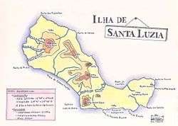
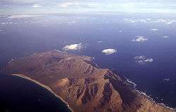
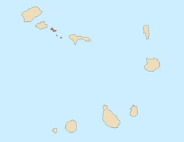
Santa Luzia is an island of the Barlavento archipelago in Cape Verde located between São Nicolau and São Vicente, the channel of Santa Luzia separates the island of São Vicente and is 8 km wide. The area is 34.2 km².[1] Like all Cape Verdean islands, it is of volcanic origin. The highest point is Topona (elevation 395 m (1,296 ft)).[2] Santa Luzia is 12.4 km long and 5.3 km wide.[3]
Administratively, it is not part of any municipality, but in the public domain of the state of Cape Verde.[4] Together with the islets of Ilhéu Branco and Ilhéu Raso, Santa Luzia is on the tentative list of UNESCO's World Heritage sites.[5] Santa Luzia, Ilhéu Branco and Ilhéu Raso were declared a protected area as Santa Luzia Nature Reserve (Reserva Natural Integral de Santa Luzia) in 1990.[6][7] In addition to the islands proper (43 km2 (17 sq mi)), the nature reserve covers 469 km2 (181 sq mi) of ocean.[1]
The island has never had permanent inhabitants, but it has been used for grazing animals.[8] In the 20th century, a meteorology station was built. Today, fishermen from the nearby islands of São Vicente and Santo Antão fish in the waters around the island. Conus santaluziensis is a species of sea snails found in the waters of Santa Luzia.[9]
References
- 1 2 Resolução nº 36/2016, Estratégia e Plano Nacional de Negócios das Áreas Protegidas
- ↑ Tactical Pilotage Chart K-0A, Perry-Castañeda Map Collection
- ↑ Cabo Verde, Statistical Yearbook 2015, Instituto Nacional de Estatística, p. 25
- ↑ Proposta do Plano de Gestão da Reserva Natural de Santa Luzia, ilhéus Branco e Raso, p. 30
- ↑ Complexe d’aires Protégées de l’île de Santa Luzia et des Ilots Branco et Raso, UNESCO
- ↑ Proposta do Plano de Gestão da Reserva Natural de Santa Luzia, ilhéus Branco e Raso, p. 30
- ↑ Reservas Naturais, Áreas protegidas Cabo Verde
- ↑ Armand d'Avezac; et al. (1848). "Sainte-Luce". Îles de l'Afrique. Paris: Firmin Didot Frères. pp. 213–214.
- ↑ World Register of Marine Species
External links
| Wikimedia Commons has media related to Santa Luzia (Cape Verde). |
- Santa Luzia at Protected Areas of Cape Verde website (in Portuguese)
| Island groups | ||
|---|---|---|
| Islands | ||
| Islets | ||