Ilhéu Grande
 | |
| Geography | |
|---|---|
| Location | Atlantic Ocean |
| Coordinates | 14°57′54″N 24°41′56″W / 14.965°N 24.699°WCoordinates: 14°57′54″N 24°41′56″W / 14.965°N 24.699°W |
| Area | 3 km2 (1.2 sq mi) |
| Length | 2.3 km (1.43 mi) |
| Width | 1.1 km (0.68 mi) |
| Highest elevation | 97 m (318 ft) |
| Administration | |
|
Cape Verde | |
| Concelhos (Municipalities) | Brava |
| Demographics | |
| Population | 0 |
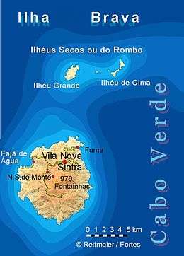
Ilhéu Grande is an uninhabited island of Cape Verde. It is the largest of the Ilhéus do Rombo islet group, located 4 km (2 mi) west of Ilhéu de Cima, the other main islet of the group, and 7 km (4 mi) north of the island Brava. They are administratively a part of the Brava municipality. Its length is 2.3 km (1.4 mi) from southwest to northeast and the width is approximately 1.1 km (0.7 mi) from southeast to northwest. The islet forms a part of the integral nature reserve Ilhéus do Rombo.[1]
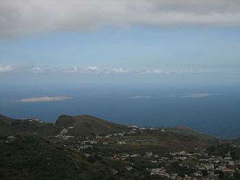
The islet is a volcanic seamount and has a rocky coastline. It is mostly barren but has some scattered vegetation.[2] Large bird colonies must have existed formerly as the island has thick layers of guano. It has been used by goat farmers and whalers in the past. The islet was mentioned as "Juan Carnira" in the 1747 map by Jacques-Nicolas Bellin.[3]
References
- ↑ Nature reserves of Cape Verde
- ↑ "Ilhéus do Rombo". Sites - Important Bird Areas. BirdLife International. Retrieved 6 August 2018.
- ↑ Jacques-Nicolas Bellin (1747). "Carte des Isles du Cap Verd = Kaart van de Eilanden van Kabo Verde" (in French).
| Island groups | ||
|---|---|---|
| Islands | ||
| Islets | ||