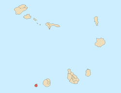
Brava, Cape Verde
 | |
 | |
| Geography | |
|---|---|
| Location | Atlantic Ocean |
| Coordinates | 14°52′N 24°42′W / 14.867°N 24.700°W |
| Area | 62.51 km2 (24.14 sq mi) |
| Length | 10.5 km (6.52 mi) |
| Width | 9.3 km (5.78 mi) |
| Highest elevation | 976 m (3,202 ft) |
| Highest point | Monte Fontainhas |
| Administration | |
|
Cape Verde | |
| Concelhos (Municipalities) | Brava |
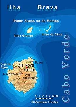
| Largest settlement | Nova Sintra |
| Demographics | |
| Population | 5,698 (2015) |
| Pop. density | 91.2 /km2 (236.2 /sq mi) |
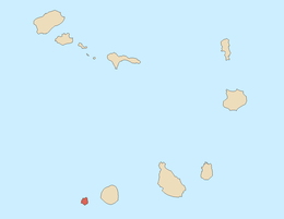
Brava (Portuguese for “wild” or "brave") is an island in Cape Verde, in the Sotavento group. At 62.5 km2 (24.1 sq mi),[1] it is the smallest inhabited island of the Cape Verde archipelago, but at the same time the greenest. First settled in the early 16th century, its population grew after Mount Fogo on neighbouring Fogo erupted in 1680. For more than a century, its main industry was whaling, but the island economy is now primarily agricultural.
History
Brava was discovered in 1462 by the Portuguese explorer Diogo Afonso.[2]:73 There is no evidence of human presence on the Cape Verde islands before the arrival of the Portuguese. Around 1620 the population of Brava started with the arrival of settlers from Madeira and the Azores.[3] Settlement of Brava took a rise in 1680 when it received many refugees from the nearby larger island of Fogo after its volcano erupted and covered the island with ash.[2]:83-84 Frequent pirate attacks forced the population towards the interior of the island, where the town Nova Sintra was founded around 1700.[3]
Around 1720, the fungus Roccella tinctoria was discovered, which was traded as a textile dye.[3] From the end of the 18th century, whaling ships from North America started hunting whales around the Azores and the Cape Verde Islands. They used the harbours of Brava (Fajã de Água and Furna) to stock up on supplies and drinking water. They hired men from Brava as sailors, and several of these men from Brava settled around the Massachusetts whaling port of New Bedford.[2]:439-440
Geography
The island of Brava is 10.5 km long (north to south) and its width is 9.3 km.[4]:21 Its area is 62.51 km2 (24.14 sq mi).[1] Practically the whole island is a stratovolcano. It lies in the lee of the enormous Fogo volcano. Volcanic activity on the island has been mainly located along three lines, which all intersect at the crest of ground that forms the highest part of the island.[5] Brava has no documented historical eruptions, but its youthful volcanic morphology and the fact that earthquake swarms still occur indicate the potential for future eruptions; its last eruption was during the Holocene era. 13% of the island area is forested.[4]:25
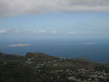
North of Brava are several uninhabited islets; the largest ones are Ilhéu de Cima and Ilhéu Grande. Monte Fontainhas is the highest point on the island, reaching 976 metres elevation.[6]
Climate
Being highly mountainous this island has a quite diverse climate. Brava island has moderate tropical climate (As according to Köppen–Geiger climate classification system) along the coast and semi-arid mild tropical climate Bsh with very balanced temperatures year round in the interior. The average annual temperature on the coast is about 23–25 °C (73–77 °F), decreasing to some 17–20 °C (63–68 °F) in the mountains. There can be remarkably cool weather with warmer wet season starting in June and ending in November with colder dry season starting in December and ending in May.
| Climate data for Cachaço, south of Nova Sintra, 800 metres ASL | |||||||||||||
|---|---|---|---|---|---|---|---|---|---|---|---|---|---|
| Month | Jan | Feb | Mar | Apr | May | Jun | Jul | Aug | Sep | Oct | Nov | Dec | Year |
| Average high °C (°F) | 18.7 (65.7) |
18.6 (65.5) |
19.4 (66.9) |
19.8 (67.6) |
20.4 (68.7) |
21.0 (69.8) |
22.2 (72) |
23.1 (73.6) |
23.3 (73.9) |
22.6 (72.7) |
21.7 (71.1) |
19.6 (67.3) |
20.9 (69.6) |
| Daily mean °C (°F) | 16.2 (61.2) |
16.1 (61) |
16.6 (61.9) |
16.9 (62.4) |
17.6 (63.7) |
18.4 (65.1) |
19.4 (66.9) |
20.5 (68.9) |
20.8 (69.4) |
20.4 (68.7) |
19.1 (66.4) |
17.4 (63.3) |
18.3 (64.9) |
| Average low °C (°F) | 13.8 (56.8) |
13.6 (56.5) |
13.8 (56.8) |
14.1 (57.4) |
14.9 (58.8) |
15.8 (60.4) |
16.7 (62.1) |
17.9 (64.2) |
18.4 (65.1) |
18.2 (64.8) |
16.5 (61.7) |
15.2 (59.4) |
16.9 (62.4) |
| Average rainfall mm (inches) | 11 (0.43) |
5 (0.2) |
1 (0.04) |
0 (0) |
0 (0) |
0 (0) |
17 (0.67) |
83 (3.27) |
123 (4.84) |
53 (2.09) |
33 (1.3) |
20 (0.79) |
346 (13.63) |
| Source: climate-data.org[7] | |||||||||||||
Population
The island is governed as one municipality: Brava. The municipality consists of two parishes: São João Baptista and Nossa Senhora do Monte. These are subdivided into 20 population zones for statistical purposes.[8] The island's main town is Nova Sintra.
Demographics
In the 1830s, the population was estimated at 8,000.[9]
| Year | Population |
|---|---|
| 1940[10] | 8,528 |
| 1950[10] | 7,937 |
| 1960[10] | 8,625 |
| 1970[10] | 7,756 |
| 1980[10] | 6,985 |
| 1990[10] | 6,975 |
| 2000[10] | 6,820 |
| 2010[1] | 5,995 |
| 2015[6]:36 | 5,698 |
Economy
The economy of the island is mainly based on (irrigated) agriculture and fishing. Main agricultural goods include coffee, potatoes including sweet potatoes, corn (maize), banana and sugar cane.[5]
Attractions
- Nova Sintra, a town with a museum, traditional Portuguese architecture, several churches and shops.
- Fajã de Agua, a small harbour on the West coast with a natural swimming pool.
- Nossa Senhora do Monte, a village in the mountains with a pilgrimage church.
- Cova Rodela, a village in the mountains with a dragon tree in its main street.

Sports
There are several football clubs on Boa Vista, organised in the Brava Regional Football Association.
Infrastructure

The Esperadinha Airport, inaugurated in 1992, was closed in 2004 because of persisting strong winds. The village of Furna has a commercial port, the other port is Fajã de Água which is only used for fishing. Ferries to the islands of Fogo and Santiago depart from Furna. On Brava the villages may be reached by "Aluguer" bus. There is no fixed schedule, as the aluguers travel only when there are sufficient passengers. A few taxis are available as well.
Notable residents
- Eugénio Tavares, musician; he used the traditional morna and wrote in Cape Verdean Creole. A statue dedicated to Eugénio Tavares is in the main square of Vila Nova Sintra, surrounded by a garden with trees, sunflowers, flowers, grass and other types of plants.
- Vinny deMacedo - Massachusetts State Representative & State Senate candidate was born in Brava.
References
- 1 2 3 2010 Census Summary
- 1 2 3 Valor simbólico do centro histórico da Praia, Lourenço Conceição Gomes, Universidade Portucalense, 2008, p. 97
- 1 2 3 Centre historique de Nova Sintra, UNESCO (in French)
- 1 2 Estatísticas do Ambiente - 2016, Instituto Nacional de Estatística
- 1 2 "Brava – sua situação geográfica" [Brava, its Geographic Location]. A Semana (in Portuguese). 31 March 2004. Retrieved 10 February 2017.
- 1 2 Cabo Verde, Statistical Yearbook 2015, Instituto Nacional de Estatística, p. 25
- ↑ "Climate Cachaço". Climate-Data.org. Retrieved 28 December 2013.
- ↑ "2010 Census results Brava". Instituto Nacional de Estatística Cabo Verde (in Portuguese). 24 November 2016.
- ↑ Roberts, Edmund (1837). Embassy to the Eastern Courts of Cochin-China, Siam, and Muscat. New York: Harper & Brothers. p. 14.
- 1 2 3 4 5 6 7 Source: Statoids
Further reading
- Armand d'Avezac; et al. (1848). "Brava". Îles de l'Afrique. Paris: Firmin Didot Frères. pp. 208–210.
External links
| Wikimedia Commons has media related to Brava (Cape Verde). |
- Brava News - News directly from Brava
- Brava island - caboverde.com
- Brava, Cape Verde Islands - University of Massachusetts
- (in Portuguese) 1930 Cartographic Map at TV Ciência (in Portuguese)
| Island groups | ||
|---|---|---|
| Islands | ||
| Islets | ||
The Island of Brava | ||
|---|---|---|
| Communities and settlements |
|  |
| Parishes | ||
| Other geographical features | ||
| Landmarks and points of interests | ||