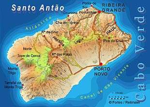
Santo Antão, Cape Verde
| Nickname: Ilha das montanhas (island of the mountains) | |
|---|---|
 | |
 Santo Antão | |
| Geography | |
| Location | Atlantic Ocean |
| Coordinates | 17°04′12″N 25°10′16″W / 17.070°N 25.171°W |
| Area | 779 km2 (301 sq mi) |
| Length | 42.8 km (26.59 mi) |
| Width | 24.0 km (14.91 mi) |
| Highest elevation | 1,979 m (6,493 ft) |
| Highest point | Tope de Coroa |
| Administration | |
|
Cape Verde | |
| Concelhos (Municipalities) | Paul, Porto Novo, Ribeira Grande |
| Largest settlement | Porto Novo |
| Demographics | |
| Population | 40,547[1]:36 (2015) |
| Pop. density | 52.1 /km2 (134.9 /sq mi) |
Santo Antão (Portuguese for "Saint Anthony") is the westernmost island of Cape Verde. At 779 km2 (301 sq mi), it is the largest of the Barlavento Islands group, and the second largest island of Cape Verde.[1]:25 The nearest island is São Vicente to the southeast, separated by the sea channel Canal de São Vicente. Its population was 40,547 in 2015, making it the third most populous island of Cape Verde after Santiago and São Vicente.[1]:36 Its largest city is Porto Novo on the south coast (population 9.310 in 2010).[2]
Geography
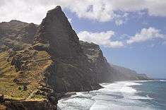
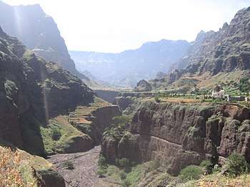
Santo Antão is 42.75 km long (east-west) and 23.97 km wide (north-south).[1]:25 The island is of volcanic origin and very mountainous, characterized by two high plateaus and several steep river valleys. The southern part of the island has a desert climate, while the northeast and the higher elevations are semi-arid.
Rivers
The main rivers of Santo Antão are:
- Ribeira de Alto Mira
- Ribeira da Cruz
- Ribeira da Garça
- Ribeira Grande
- Ribeira da Janela
- Ribeira do Paul
- Ribeira das Patas
- Ribeira da Torre
Mountains
The tallest mountain is Tope de Coroa, reaching an elevation of 1,979 m.[1]:25 Other high mountains on the island are Monte Tomé (1,863 m), Gudo de Cavaleiro (1,810 m), Monte Moroços (1,767 m) and Pico da Cruz (1,584 m).
Climate
Santo Antão island has moderately dry tropical climate (As according to Köppen–Geiger climate classification system) along the coast and semi-arid mild tropical climate Bsh with very balanced temperatures year round higher on the slopes (~ 800 metres ASL) to cool highland subtropical steppe climate BskL above 1,000 metres above ASL. The average annual temperature on the coast is about 23 °C (73 °F), decreasing to some 11 to 15 °C (52–59 °F) on the highest grounds. There can be remarkably cool weather in the interior with warmer wet season starting in July and ending in December–January with colder dry season starting in December–January and ending in June. The major climate risk, similarly to other Cape Verdean islands, yet much less pronounced in the higher altitudes due to better ability in gaining moisture from clouds, is drought.
| ||||||||||||||||||||||||||||||||||||||||||||||||||||||||||||||||||||||||||||||||||||||||||||||||||
| ||||||||||||||||||||||||||||||||||||||||||||||||||||||||||||||||||||||||||||||||||||||||||||||||||
| ||||||||||||||||||||||||||||||||||||||||||||||||||||||||||||||||||||||||||||||||||||||||||||||||||
History
The island was discovered in 1461 or 1462 by Diogo Afonso, together with the islands of São Vicente and São Nicolau.[3]:73 Settlement of the island started in the first half of the 16th century. The main settlement was Ribeira Grande. Other settlements such as Ponta do Sol, Pombas and Porto Novo developed in the 19th century.
In 1732 the Municipality of Santo Antão was created, with its seat in the town Ribeira Grande.[4] In 1867 this was divided into the municipality of Paul (covering the area of current Paul and Porto Novo) and the municipality of Ribeira Grande. These were merged in 1895 into one municipality. The municipalities of Paul and Ribeira Grande were recreated in 1917.[5] The municipality of Porto Novo was created in 1962 when the parishes of São João Baptista and Santo André were separated from the older Municipality of Paul.[5]
Population
In the 1830s, the estimated population of Santo Antão was 24,000.[6]
| Year | Population |
|---|---|
| 1940[7] | 35,977 |
| 1950[7] | 28,379 |
| 1960[7] | 33,953 |
| 1970[7] | 44,623 |
| 1980[7] | 43,321 |
| 1990[7] | 43,845 |
| 2000[7] | 47,124 |
| 2010[8] | 43,915 |
| 2015[1]:36 | 40,547 |
Economy
Fishing and agriculture are the main industries on the island.
Agriculture
The island's agriculture products include sugar cane, yams, cassava, bananas, mangoes, and grain. The main product on the island is a kind of rum known as grogue. Mills continue to distill grogue in the Paul Valley.
Due to its mountainous nature, most of the island's plantations are done in terraces, obviating the use of machinery and requiring immense manual labor. Recently, some experiences using Drip irrigation have been taking place in order to mitigate the drought conditions.
The first sugar cane was exported from other Macaronesian Islands, sugar became the island's chief agricultural production from the mid 19th century.
The exportation of many of the island's agriculture products to other islands has been prohibited for nearly two decades because of the millipede (Spinotarsus caboverdus) blight, but the government announced it had going lifted the quarantine.[9]
Tourism
Tourism is becoming one of the most dominant industries on the island. There has been some investment in Rural tourism infrastructures. Hiking, Trekking and Cultural tourism account for most of the touristic offer of this island.
Administrative divisions
The island is divided in three municipalities, which are subdivided into civil parishes:
Nature
Santo Antão has 50 endangered species of flora which has the most number in the nation. Several flora found in the island that are also found in some parts of the archipelago includes Aeonium gorgoneum, Artemisia gorgonum, Campanula jacobaea, the Conyza species of feae, pannosa and varia, Echium stenosiphon, Kickxia webbiana, Lavandula rotundifolia, Limonium braunii, Micromeria forbesii, Sonchus daltonii, Capeverdean navelwort (Umbilicus schmidtii) and Verbascum capitis-viridis. Flora found only in the island include Tornabenea insularis and ribeirensis.
Santo Antão has different species of birds including the Cape Verde (Iago) sparrow, reptiles including the Cape Verde wall gecko and insects including the spider Tetragnatha torrensis, the moth Scopula paneliusi and the water bear Echiniscus clavispinosus. The island does not have a lot of animal life comparing to other islands. Along its shores, most of the marine life are within Canal de São Vicente.
Culture
Other than Portuguese (official language), the majority of the population speaks Cape Verdean Creole.
Persons
- Jorge Ferreira Chaves (1920–1982), Portuguese architect
- Leão Lopes (b. 1948), writer, professor and entertainment director
- Gabriel Mariano, essayist, novelist and poet
- Luís Romano de Madeira Melo, composer
- Manuel de Novas, songwriter
- Roberto Duarte Silva (1837–1889), chemist
- Antoninho Travadinha, violinist
External links
| Wikimedia Commons has media related to Santo Antão (Cape Verde). |
- University of Massachusetts - information and images from Santo Antão
- caboverde.com
References
- 1 2 3 4 5 6 Cabo Verde, Statistical Yearbook 2015, Instituto Nacional de Estatística
- ↑ "2010 Census results Santo Antão". Instituto Nacional de Estatística Cabo Verde (in Portuguese). 24 November 2016.
- ↑ Valor simbólico do centro histórico da Praia, Lourenço Conceição Gomes, Universidade Portucalense, 2008
- ↑ Evolução histórica do concelho do Porto Novo, Andreza Costa Dias, 2006, p. 12
- 1 2 Inventário dos recursos turísticos do município do Paúl, Direcção Geral do Turismo, p. 16
- ↑ Roberts, Edmund (1837). Embassy to the Eastern Courts of Cochin-China, Siam, and Muscat. New York: Harper & Brothers. p. 14.
- 1 2 3 4 5 6 7 Source: Statoids
- ↑ 2010 Census Summary
- ↑ Agriculture producers from Santo Antão can now export to Sal and Boa Vista, A Semana online, 9 January 2008
| Island groups | ||
|---|---|---|
| Islands | ||
| Islets | ||
Coordinates: 17°04′12″N 25°10′16″W / 17.070°N 25.171°W
| Authority control |
|---|