Ponta do Sinó
| Ponta do Sinó | |
|---|---|
.jpg) The lighthouse and the headland facing about southwest and the point | |
 | |
| Location |
Southern Sal, Cape Verde near Santa Maria |
| Coordinates | 16°35′06″N 22°55′16″W / 16.5851°N 22.921°WCoordinates: 16°35′06″N 22°55′16″W / 16.5851°N 22.921°W |
| Offshore water bodies | Atlantic Ocean |
Ponta do Sinó is the southernmost point of the island of Sal in Cape Verde.[1] It lies 2 km southwest of Santa Maria city centre. The area north of the headland is a protected area: nature reserve Ponta do Sinó, at the edge of a large tourism development zone.[2] There is a lighthouse on the headland, Farol da Ponta do Sinó, built in 1892.[3][4]
.JPG)
Riu Funana hotel located near Ponta do Sinó
See also
References
- ↑ Cabo Verde, Statistical Yearbook 2015, Instituto Nacional de Estatística, p. 26
- ↑ Reservas Naturais, Áreas protegidas Cabo Verde
- ↑ List of Lights, Pub. 113: The West Coasts of Europe and Africa, the Mediterranean Sea, Black Sea and Azovskoye More (Sea of Azov) (PDF). List of Lights. United States National Geospatial-Intelligence Agency. 2018. p. 426.
- ↑ Rowlett, Russ. "Lighthouses of Cape Verde". The Lighthouse Directory. University of North Carolina at Chapel Hill. Retrieved 15 August 2018.
The island of Sal, Cape Verde | ||
|---|---|---|
| Settlements | 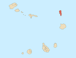 | |
| Mountains and hills | ||
| Points and promontories | ||
| Lighthouses | ||
| Other geographical features | ||
| Other topics | ||
This article is issued from
Wikipedia.
The text is licensed under Creative Commons - Attribution - Sharealike.
Additional terms may apply for the media files.