Darlaston
| Darlaston | |
|---|---|
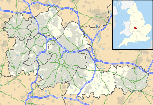 Darlaston Darlaston shown within the West Midlands | |
| Population | 27,821 (2011.Wards)[1][2] |
| OS grid reference | SO9797 |
| Metropolitan borough | |
| Metropolitan county | |
| Region | |
| Country | England |
| Sovereign state | United Kingdom |
| Post town | WEDNESBURY |
| Postcode district | WS10 |
| Dialling code | 0121 |
| Police | West Midlands |
| Fire | West Midlands |
| Ambulance | West Midlands |
| EU Parliament | West Midlands |
Darlaston is a town in the Metropolitan Borough of Walsall in the West Midlands of England.
Topography
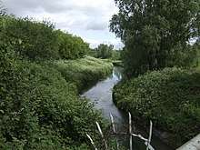
Darlaston is situated between Wednesbury and Walsall in the valley of the River Tame in the angle where the three major head-streams of the river converge. It is located on the South Staffordshire Coalfield and has been an area of intense coal-mining activity. The underlying coal reserves were most likely deposited in the Carboniferous Period.
Disused coal mines are found near Queen Street in Moxley, behind Pinfold street JMI School, near Hewitt Street and Wolverhampton Street, in George Rose Park and behind the police station in Victoria Park.
Mining subsidence, which has taken its toll on many buildings across central England, has also made its mark in Darlaston. In 1999, a council house on the New Moxley housing estate collapsed down a disused mineshaft while its occupants were on holiday. The adjoining house also had to be knocked down.
History
The ancient origins of the town are now very obscure the archive record being relatively recent. Any archaeological evidence has been largely destroyed due to intensive coal mining during the 18th and 19th centuries
Between the 12th and 15th centuries de Darlaston family were the landowners, When the de Darlaston family died out, the manor was taken over by the Hayes family and was known as Great Croft.
Darlaston's location on the South Staffordshire Coalfield led to the early development of coal mining and associated industrial activities. At first such activity was relatively small scale requiring only a copyhold permission from the lord of the manor. So, for example, in 1698 Timothy Woodhouse was manager of the coal mines belonging to Mrs. Mary Offley, then the lady of the manor. In the first year, he sold 3,000 sacks of coal and later went into partnership in his own business.
Notable beneficiaries of nineteenth-century industrialisation were the Rose family whose fortune had been made by astute enclosure of common land. Upon the death of Richard Rose in 187O his estate was valued at over £877. He bequeathed the land to his wife Hannah. His brother was James Rose, shown in the 1871 census as a latch, bolt and nut maker, employing 39 people, including 19 children. By the time of the 1881 census, James Rose was 55 and his business had expanded to employ 90 people.[3] James Rose died in 1901.[4]
Rapid industrial growth in the early decades of the 19th century brought with it problems of housing poverty and deprivation. In December 1839, the rector of the parish reported that there were approximately 1,500 homes in the parish of Darlaston, most of which were in poor condition and owned by working-class people. In 1841 the town had a population of 6,000. Development was driven by the presence of excellent transport links: the Birmingham Canal Navigations and Grand Junction Railway.[5] Much of the mining land was owned by the Birmingham Coal Company.
On 1 January 1895 Darlaston became an urban district, and the local board became Darlaston Urban District Council. In 1966, Darlaston became part of Walsall and in 1974, it became part of the metropolitan county of the West Midlands.[6]
Darlaston was subject to a numner of bombing raids in World War II. A Luftwaffe bombing on 5 June 1941 wrecked several council houses in Lowe Avenue, Rough Hay, and killed 11 people. The bomb had been aimed at Rubery Owen's factory but missed by some distance. The houses were later rebuilt.[7]
Many Victorian terraced houses were demolished during the second half of the 20th century, and the Urban District Council of Darlaston built thousands of houses and flats to replace them with. From 1966, Darlaston was administered by Walsall borough and is now in the WS10 postal district which also included neighbouring Wednesbury. Hoever, since 1999 the council owned housing stock has controlled by Darlaston Housing Trust. In 2001, two of the town's four multi-storey blocks of flats were demolished, and the remaining two were demolished in 2004. .
By the end of the 1980s, most of the industry in the town had closed and the town is now considered a ghost town, with an increasing high level of unemployment.In 2011, a total of 15 derelict sites in the town were designated as enterprise zones, offering tax breaks and relaxed planning laws to any businesses interested in setting up bases in the selected areas. The Enterprise Zone is expected to create thousands of jobs and ease the town's long running unemployment crisis, which has deepened since 2008 as a result of the recession.[8]
Education
The town is served by one large secondary school, Grace Academy, which was known as Darlaston Comprehensive School until September 2009. It is situated in the west of the town near the border with Bilston.
Notable buildings
All Saints church
All Saints' Church, Darlaston (1872) was destroyed by enemy air raids in July 1942. A new church opened in 1952, designed by local architect Richard Twentyman. It is Grade 2 listed.
Bentley Old Hall
Bentley Old Hall stood in the north of Darlaston until the early 20th century. Bentley Hall was one of several country houses where in 1651 - after the Battle of Worcester - the future Charles II was sheltered, here by Colonel John Lane. The future king finally escaped disguised as the servant of Jane Lane, the colonel's sister. Bentley Old Hall grounds were redeveloped as a housing estate in the 1950s.[9]
Darlaston Manor House
The location of the manor house is believed to be congruent with the Asda supermarket car park, slightly south west of the original parish church, now St Lawrence's Church.[10]
Darlaston Town Hall
This attractive Queen Anne Style building in Victoria Road was designed by the Birmingham architect Jethro Anstice Cossins (1830-1917), and it was opened in 1888, built on the site of one of the town's two workhouses. It comprised municipal offices, a public library and a public hall.[11] Between 2006 and 2008 the building was restored by Walsall Borough Council at a cost of about £400,000. The main building now houses local Social Services departments, while the hall continues to be used for public meetings, concerts of music and other entertainments.[12]
The pipe organ
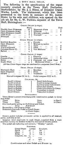
By 1903 the public hall was adorned with a fine new pipe organ, a gift to the town from the widow of James Slater, an ex-chairman of the Local Board, in his memory. The instrument was built by the West Yorkshire firm of J. J. Binns and is still in use.[13] In June 2018 the Darlaston Town Hall pipe organ was recognised of outstanding national importance by the British Institute of Organ Studies (BIOS) - the UK's amenity society for pipe organs - and is listed as Grade 1 in the UK Historic Organs Scheme for being: an unaltered example of a town hall organ of 1903 by J. J. Binns and from the firm’s finest period.[14]
Darlaston Windmill
Darlaston also had its own windmill from as early as 1695, when it appears on a map of that date. The mill continued to be in use until about 1860.[15]
St Lawrence Darlaston
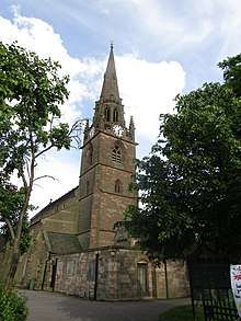

The fine looking Grade-2-listed St Lawrence’s church as we see it today is largely late nineteenth century - the work of A. P. Brevitt - but the site dates back to early medieval times.[16] The church registers date back to 1539 and may be viewed at the County Archives in Stafford. The Bishop's Transcripts are to be found at Lichfield Record Office.[17]
A generous grant from the UK Heritage Lottery Fund enabled the complete redecoration of the church’s interior in 2018.[18]
Notable residents
Media
- Mark Rhodes, runner-up in ITV's Pop Idol 2003 contest, and children's television presenter, is also from Darlaston.
Music
- John Fiddler, musician, member of 1970s band Medicine Head.
Sport
- Billy Annis (1878–1944) played 143 games in defence for Wolverhampton Wanderers between 1898 and 1905.
- Stuart Elwell professional boxer and former Midlands Welterweight Champion comes from Darlaston.
- Syd Gibbons (b.1907), professional footballer, born in Darlaston.
- Graham Hawkins (b. 1946), ex footballer and manager of Wolverhampton Wanderers was born in Darlaston
- Mark Lewis-Francis (b.1982), sprinter, born in Darlaston.
- Jimmy McIntyre (b. 1881), football manager, born in Darlaston and started his playing career with the local football team.
- Netan Sansara, first Asian to play for the England U-18 team, and also plays regularly for League One Walsall FC, is also a Darlaston native. Netan also attended Darlaston Comprehensive School. Sansara's Grandfather Ram Sansara also owned two pubs in Darlaston "The Three Horse Shoes" on Pinfold Street and "The Duke Of York" on Dangerfield Lane.
Neighbourhoods
- Rough Hay: a predominantly interwar council housing area in the north of the town close to the border with Willenhall.
- Moxley: an established private and council residential area in the west of the town close to the border with Bilston.
- Kings Hill: a mixed residential area near the town centre which includes many types of housing as well as several factories and business units.
- Woods Bank: a predominantly interwar council housing area in the south of the town close to the border with Wednesbury.
- Bentley: the most northernly area in Darlaston which was mostly developed after 1945 but is now included in the Walsall postal district.
Public transport
Buses
Buses which serve Darlaston Town Centre, stop at Darlaston Town Bus Interchange. These services are listed below.
Additional services which briefly enter Darlaston are the Banga Buses & Choice Travel 530, between the Rocket Pool and Wolverhampton via Bilston and the 57 between Ettingshall and Wolverhampton, the 680 between Moxley and Bilston via Lower Bradley & the 523 between Wednesbury and Stowlawn all operated by Choice Travel.
Canals
The Walsall Canal and Tame Valley canal run through the town.
Rail
- Darlaston railway station closed in 1887 and there is little evidence of its existence at the site, although the former trackbed is in use as a footpath.
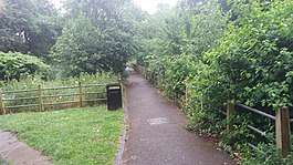 Site of Darlston railway station
 - Darlaston James Bridge railway station closed in 1965 and there is little evidence of the existence at the site. The lines through the station are in use today as part of the Walsall to Wolverhampton Line. A new station is planned for 2017.
 Site of James Bridge station, Darlaston
Roads
Since the early 1970s, the town centre has been by-passed by St Lawrence's Way, which runs between The Green and Bull Stake. No motorway runs through the town, but a section of the M6 between J9 and J10 may be considered to be in Darlaston.
Trams
Since 1999 there has been a Midland Metro stop on Bradley Lane in the Moxley area of the town. An initial plan was for the Metro to have a stop in Picturdrome Way using the old Darlaston railway line but this was abandoned.
Recreation
Football
Darlaston Town Football Club
The town's football club was formed in 1874 and is one of the oldest non league clubs in the country.
Open spaces
The town has a few small open spaces including Broadwaters road playing field, Kings Hill Park, George Rose Park and Victoria Park.
References
- ↑ "Bentley and Darlaston North Ward population 2011". Retrieved 19 December 2015.
- ↑ "Darlaston South Ward population 2011". Retrieved 19 December 2015.
- ↑ William Foot; Geraldine Beech; Rose Mitchell (2004). Maps for Family and Local History: The Records of the Tithe, Valuation Office and National Farm Surveys of England and Wales, 1836 - 1943. Dundurn Press Ltd. p. 102. ISBN 1-55002-506-6.
- ↑ William Foot; Geraldine Beech; Rose Mitchell (2004). Maps for Family and Local History: The Records of the Tithe, Valuation Office and National Farm Surveys of England and Wales, 1836 - 1943. Dundurn Press Ltd. p. 103. ISBN 1-55002-506-6.
- ↑ William Foot; Geraldine Beech; Rose Mitchell (2004). Maps for Family and Local History: The Records of the Tithe, Valuation Office and National Farm Surveys of England and Wales, 1836 - 1943. Dundurn Press Ltd. p. 101. ISBN 1-55002-506-6.
- ↑ Bev Parker. "A New Town Hall". A Brief History of Darlaston. University of Wolverhampton. Archived from the original on 8 October 2006. Retrieved 2008-03-30.
- ↑ "Archived copy". Archived from the original on 14 May 2010. Retrieved 5 May 2010.
- ↑
- ↑ The Redisovery of Bentley Hall, Walsall by Michael Shaw and Danny McAree (2007); online resource, accessed 1 July 2018
- ↑ Bev Parker. "Beginnings". A Brief History of Darlaston. University of Wolverhampton. Archived from the original on 31 March 2008. Retrieved 2008-03-30.
- ↑ 'Town Hall, Victoria Road' in Darlaston's Listed Buildings by Bev Parker (no date); online resource accessed 1 July 2018
- ↑ 'A New Town Hall' in A Brief History of Darlaston by Bev Parker (no date); online resource accessed 1 July 2018
- ↑ 'A New Town Hall' in A Brief History of Darlaston by Bev Parker (no date); online resource accessed 1 July 2018
- ↑ 'Staffordshire Darlaston, Town Hall, Victoria Road' in National Pipe Organ Register (2018); online resource accessed 1 July 2018
- ↑ Bev Parker. "Early Growth". A Brief History of Darlaston. University of Wolverhampton. Archived from the original on 31 March 2008. Retrieved 2008-03-30.
- ↑ ‘St Lawrence’s Church Building’ in parish website. Online resource accessed 18 July 2018.
- ↑ ‘The church of St Lawrence’, A brief history of Darlaston: churches and chapels by Bev Parker (no date). Online resource, accesssed 18 July 2018.
- ↑ ‘The parish church of St Lawrence’ in Bagnalls Group of Companies. Online resource accessed 18 July 2018.