Lake Seminole
| Lake Seminole | |
|---|---|
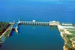 Jim Woodruff Lock and Dam. This earthen dam is over one mile (1.6 km) long but this photograph shows only the concrete and steel lock and water control structure of the dam. Florida is on the left, Georgia the right. | |
| Location |
Georgia–Florida border, United States |
| Coordinates | 30°42′29″N 84°51′47″W / 30.708°N 84.863°WCoordinates: 30°42′29″N 84°51′47″W / 30.708°N 84.863°W |
| Primary inflows | Chattahoochee, Flint River |
| Primary outflows | Apalachicola River |
| Catchment area | 17,200 sq mi (44,548 km2) |
| Basin countries | United States |
| Max. length | 35 mi (56 km) |
| Max. width | 2 mi (3.2 km) |
| Surface area | 37,500 acres (152 km2) |
| Average depth | 10 ft (3.0 m) |
| Max. depth | 30 ft (9.1 m) |
| Shore length1 | 376 mi (605 km) |
| Surface elevation | 77.5 ft (23.6 m) |
| 1 Shore length is not a well-defined measure. | |
Lake Seminole is a reservoir located in the southwest corner of Georgia along its border with Florida, maintained by the U.S. Army Corps of Engineers. The Chattahoochee and Flint rivers join in the lake, before flowing from the Jim Woodruff Lock and Dam, which impounds the lake, as the Apalachicola River. The lake contains 37,500 acres (152 km2) of water, and has a shoreline of 376 mi (605 km).[1] The fish in Lake Seminole include largemouth bass, crappie, chain pickerel, catfish, striped bass and other species. American alligators, snakes and various waterfowl are also present in the lake, which is known for its goose hunting.[2][N 1]
History
Authorised by the United States Congress in the Rivers and Harbors Act of 1946 as the Jim Woodruff Lock and Dam Project,[4] construction began the following year. With the dam completed in 1952,[5] in 1957 the lake was opened.[4] The project was expected to cost $29 million USD,[6] but when completed had required $46.5 million USD.[7]
In 2000 a Tallahassee man, Michael Williams, apparently drowned during a duck-hunting accident on the Jackson County side of the lake. However, his body was never found after a 44-day search, the only time a body has never been recovered after a drowning on the lake. Searchers assumed it had been eaten by alligators, but several years later learned that alligators do not feed in winter. Other oddities with the incident convinced them to suspect foul play; the case remains under investigation.[8]
Jim Woodruff Dam
The Jim Woodruff Dam, located about 1,000 feet (300 m) south of the original confluence of the Chattahoochee River, Flint River and Spring Creek to form the Apalachicola River[9] and with a spillway 2,224 feet (678 m) wide,[5] is a hydroelectric and navigational dam named in honor of James W. Woodruff, Sr., a Georgia businessman who spearheaded the development of the Apalachicola-Chattahoochee-Flint Project.[9]
The dam crosses the state line between Georgia and Florida, with the eastern end of the dam being located in Georgia.
Navigation
The Jim Woodruff Dam has a single lock, 450 feet (140 m) in length and 82 feet (25 m) wide,[5] that provides navigational access to the lake and the upstream rivers from the Apalachicola River and Gulf of Mexico. Lake Seminole extends upstream along the Chattahoochee River for 30 miles (48 km) and up the Flint River for 35 miles (56 km).[7]
Parks
The U.S. Army Corps of Engineers maintains 10 parks along the shore of the lake,[10] with 35 parks in total available for recreation, including five campgrounds.[11] Seminole State Park covers 604 acres (244 ha) of lakeshore in Georgia, while Three Rivers State Park covers 686 acres (278 ha) of wetland[12] north of Sneads, Florida.
San Carlos de los Chacatos
The West Bank Overlook at the western end of the dam is the location of the Spanish mission San Carlos de los Chacatos, established in 1674 following a revolt by the Chacato.[13][14] Used by both Marcos Delgado and Don Laureano de Torres y Ayala on their expeditions,[14] the mission was attacked by Alibamu warriors in 1696,[14] then later by British forces led by Colonel James Moore during Queen Anne's War and abandoned.[13]
Resettled during the Creek War in 1813 by Uchee refugees, the site was abandoned again in 1818 during the First Seminole War, and was not rediscovered until 1948 during archaeological work by the Florida Park Service supporting the construction of Lake Seminole.[14]
Fort Scott
Fort Scott was built in 1816 on the west bank of the Flint River, just before it empties into the Apalachicola. The intent was to protect what was then the southern border of the United States (the border between Georgia and Florida), subject to various types of invaders operating through or out of Spanish territory. The Fort was abandoned after Florida became a U.S. territory in 1821 and there was no longer a border to defend. The site is under Lake Seminole.
Notes
Lake Seminole is known for its large bass fishing during summer months and duck hunting in the early winter. It has also been a location of preference for the well renowned Bassmasters.
- ↑ For many years, The Canada goose was protected throughout most of Florida, with one exception, it was legal to hunt the goose on Lake Seminole.[2] However, increases in the feral population has led to the season being opened statewide.[3]
References
- Notes
- ↑ Lake Seminole page, main page, U.S. Army Corps of Engineers website
- 1 2 FWCC: Waterfowl and coot season dates set (2007)
- ↑ FWC Hunting Regulations 2009-2010
- 1 2 U.S. Army Corps of Engineers: Corps Lakes Gateway
- 1 2 3 Lakes Online: Lake Seminole
- ↑ Palm Beach Post, 4 October 1947
- 1 2 Lake Seminole page, Information page, U.S. Army Corps of Engineers website
- ↑ Portman, Jennifer (December 14, 2006). "Six years ago, this hunter disappeared". Tallahassee Democrat. Retrieved November 8, 2015.
- 1 2 Apalachicola-Chattahoochee-Flint River System History page
- ↑ Lake Seminole page, parks page, U.S. Army Corps of Engineers website
- ↑ Great Lakes in Georgia
- ↑ Three Rivers State Park brochure
- 1 2 ARROW: History: Jackson County
- 1 2 3 4 Jackson County, Florida Historic Sites and Research site
- Bibliography
- "Lake Seminole". U.S. Army Corps of Engineers. Archived from the original on 2010-01-26. Retrieved 2010-04-11.
- "Corps Lakes Gateway: Florida - Seminole Lake". U.S. Army Corps of Engineers. Retrieved 2010-04-11.
- "History & Facts: Lake Seminole". Great Lakes of Georgia. Retrieved 2010-04-11.
- "Welcome to Three Rivers State Park" (PDF). Florida Park Service. Retrieved 2010-04-22.
- "JIM WOODRUFF DAM (Lake Seminole)". Lakes Online. Retrieved 2010-04-22.
- "Apalachicola-Chattahoochee-Flint River System History". U.S. Army Corps of Engineers. Archived from the original on 2010-05-07. Retrieved 2010-04-22.
- "Woodruff Breaks Ground for Dam". Palm Beach Post. 4 October 1947. p. 1.
- "Jackson County, Florida Historic Sites and Research:San Carlos de Chacatos". Explore Southern History. Retrieved 2010-04-22.
- "History: Jackson County". Apalachicola Region Resources On the Web. Retrieved 2010-04-22.
- "Waterfowl and coot season dates set". Florida Fish and Wildlife Conservation Commission. Retrieved 2010-04-26.
- "2009-2010 Migratory Bird Regulations for Dove, Snipe, Woodcock, Rail, Moorhen, Crow and early Waterfowl Seasons" (PDF). Florida Fish and Wildlife Conservation Commission. Retrieved 2010-04-26.
External links
| Wikimedia Commons has media related to Lake Seminole. |
- Official map
- Jim Woodruff Dam
- Shoreline of Florida's Pan-Handle, Jim Woodruff Lock and Dam
- Lake Seminole Resources