Chattooga River
| Chattooga River | |
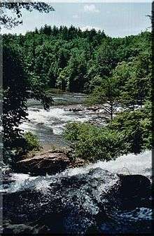 Chattooga River near Dick's Creek Falls | |
| Country | United States |
|---|---|
| Type | Wild, Scenic, Recreational |
| Designated | May 10, 1974 |
The Chattooga River (also spelled Chatooga, Chatuga, and Chautaga, variant name Guinekelokee River) is the main tributary of the Tugaloo River. Its headwaters are located southwest of Cashiers, North Carolina, and it stretches 57 miles (92 km)[1] to where it has its confluence with the Tallulah River within Lake Tugalo, held back by the Tugalo Dam. The Chattooga and the Tallulah combine to make the Tugaloo River starting at the outlet of Lake Tugalo. The Chattooga begins in southern Jackson County, North Carolina, then flows southwestward between northwestern Oconee County, South Carolina, and eastern Rabun County, Georgia. The "Chattooga" spelling was approved by the US Board on Geographic Names in 1897.[2]
The Chattooga River flows into Tugalo Lake where it joins the Tallulah River. After flowing through Tugalo Dam the combined rivers become the Tugaloo River which, along with the Seneca River, becomes the Savannah River below Lake Hartwell. Downstream from that point, the water flows into the Atlantic Ocean near Savannah, Georgia. The Chattooga was used as a setting for the fictional Cahulawassee River in the book and film Deliverance.
Geology
The Chattooga River serves as part of the boundary between Georgia and South Carolina near latitude 35°N. The Chattooga River was not the original boundary line between South Carolina and Georgia. A treaty of 1816 extended the South Carolina boundary to its current location. Prior to 1816, the Chattooga was on the lands of the Cherokee Indian Nation.
The Blue Ridge Mountains, where the Chattooga starts, are considered to be ancient, even by geological standards. The rock is mostly granite. Geologists believe that the Chattooga may have made one direction change during its life. Originally, it probably flowed southwesterly into the Chattahoochee riverbed and on to the Gulf of Mexico, but at some point, the Savannah River eroded its northern headland until it intersected the Chattooga and diverted it to the Atlantic.
The rocks in the riverbed probably fell from the ridge above, but those rocks do not necessarily remain where they fall. In times of great downpours, high water, and fast currents, rocks can become dislodged and move downstream, taking other rocks and debris with them. During Hurricane Ivan in 2004, the wind force and waters knocked down big boulders off the sides. The hurricane released enough water in the Chattooga watershed to bring the river to its highest recorded flow rate, around 26,000 cu ft/s (740 m3/s) to 28,000 cu ft/s (790 m3/s), rivaling the typical flow of the Grand Canyon.
Wild and Scenic River
Since May 10, 1974, the Chattooga River has been protected along a 15,432-acre (6,245 ha) corridor as a national Wild and Scenic River. 39.8 miles (64.1 km) of the river have been designated “wild”, about 2.5 miles (4.0 km) “scenic”, and 14.6 miles (23.5 km) “recreational” for a total of about 57 miles (92 km). On the commercially rafted sections (III and IV) there is a 1/4 mile protected corridor of National Forest on both sides of the river, allowing no roads to the river or development of any kind. There are a few areas on the river where access has been made more accessible on Section III, but much of Section IV is fairly remote. The Chattooga also bisects the Ellicott Rock Wilderness which straddles three states (Georgia, North Carolina and South Carolina) and three National Forests (the Chattahoochee, Nantahala and Sumter National Forests). Much of the Georgia portion of the river is within the Chattooga River Ranger District of the Chattahoochee National Forest.
Known as the "Crown Jewel" of the southeast, the Chattooga was the first river east of the Mississippi to be granted the Wild & Scenic designation, and is still the only one that is commercially rafted.
Tributaries
The river is split into three forks. The Chattooga River is the main fork, running along the state line. The East Fork Chattooga River (sometimes East Prong Chattooga River) runs in from Jackson County, North Carolina and then Oconee County, South Carolina, and is 7.4 miles (11.9 km) long.[1] The West Fork Chattooga River (variant name Gumekoloke Creek) runs 6.0 miles (9.7 km)[1] in from Rabun County, Georgia, and is also a variant name for that county's Holcomb Creek, one of its own tributaries.
One of the largest tributaries in the Chattooga basin that flows mainly through private lands is Stekoa Creek, which flows primarily southeast for approximately 18 miles (29 km)[1] from its headwaters in Mountain City, Georgia, through Clayton, Georgia, to its mouth at the Chattooga River. Stekoa Creek has been the single greatest threat to the Chattooga's water quality for over 40 years, due primarily to raw sewage leaking from the City of Clayton, GA's old sewage collection system, storm drains overflowing, sediment-laden runoff, poor agricultural practices, failing septic systems, and dumping from apathetic individuals.[3] The Chattooga Conservancy, a non-profit organization dedicated to the protection, promotion and restoration of the Chattooga River watershed, has made the neglected issue of improving water quality in Stekoa Creek a top priority.[4] The Stekoa Creek Basin is approximately 45 square miles (120 km2) in size.
Rafting and boating

In the late spring, the river is lined with blooming pink and white mountain laurel. Early spring is also a great time to go rafting, kayaking, or canoeing because of the higher flows and cooler temperatures. The Chattooga is a free-flowing river (no upstream dam to control the flow) which quickly responds to rainfall or drought conditions. As a drop-pool style river, rapids are followed by calm pools for swimming.
The Chattooga headwaters start near Cashiers as a small stream, but Green Creek is the start of the boatable section. Section I is the West Fork and is ideal for tubing and class II float trips.[5] Section II starting at Highway 28 is a class II float.[6] Section III has Class II-IV rapids which rafters and kayakers frequent. The final rapid in Section III is Bull Sluice.[7] Section IV includes Class II-V rapids, including the famous Five Falls (five class III-V rapids in roughly a 1/4 mile stretch).[8] The minimum age requirement to raft Section III is 8, and Section IV is 12. A number of signature rapids on this river were featured in the motion picture Deliverance.
The Forest Plan, issued in 1976 and revised in January 2004, restricted motorized craft, closed many roads to the river and prohibited floating on the upper 21 miles (34 km) of river. This plan was challenged by several boating advocacy groups, causing the United States Forest Service to withdraw the plan of 2004 and ordering a Visitor Use Capacity Analysis.[9] The USFS issued its final decision in January 2012.[10] The decision expanded boating onto some sections of the upper Chattooga with a number of restrictions based on season, section of river, property ownership, time of day, and water level. The decision has proved controversial due to the extensive amount of deaths of the river. Boating remains illegal above Greens Creek and Below Licklog creek. This section is difficult, flows infrequently, and will likely see limited whitewater use.
Notes
- 1 2 3 4 U.S. Geological Survey. National Hydrography Dataset high-resolution flowline data. The National Map Archived 2012-04-05 at WebCite, accessed April 26, 2011
- ↑ U.S. Geological Survey Geographic Names Information System: Chattooga River
- ↑ http://chattoogariver.org/stekoa-creek-campaign/
- ↑ http://chattoogariver.org/stekoa-creek-campaign/
- ↑ American Whitewater - Overflow Creek Road Bridge to Highway 28 Boater's Access, Chattooga, West Fork Georgia, US
- ↑ American Whitewater - Section 2 - Highway 28 Putin to Earl's Ford, Chattooga Georgia, US/South Carolina, US
- ↑ American Whitewater - Section 3 - Earls Ford to Route 76 Bridge, Chattooga Georgia, US/South Carolina, US
- ↑ American Whitewater - Section 4 - Route 76 Bridge to Tugaloo Lake Boat Ramp, Chattooga Georgia, US/South Carolina, US
- ↑ "Archived copy" (PDF). Archived from the original (PDF) on 2010-06-15. Retrieved 2009-11-24.
- ↑ Francis Marion and Sumter National Forests - Home
References
- Clay, Butch (1995). A Guide to the Chattooga River, Chattooga River Publishing.
- Tetra Tech EC, Inc. (August 25, 2006). Chattooga River History Project Literature Review and Interview Summary, USDA Forest Service.
External links
- The Chattooga Conservancy's official website
- Photos & more info on Chattooga River Activities
- Francis Marion and Sumter National Forests official site
- Chattooga River History Project Literature Review and Interview Summary
- National Whitewater River Inventory: Section 00, Class IV
- National Whitewater River Inventory: Section 0, Class IV-V
- National Whitewater River Inventory: Section 1, Class IV-v
- National Whitewater River Inventory: Section 2, Class II
- National Whitewater River Inventory: Section 3, Class III+
- National Whitewater River Inventory: Section 4, Class IV+
Coordinates: 35°04′06″N 83°06′56″W / 35.0681968°N 83.115585°W