West Point Lake
| West Point Lake | |
|---|---|
 | |
| Location | Troup County, Ga., and Heard County, Ga., and Chambers County, Ala. |
| Coordinates | 32°55′07″N 85°11′17″W / 32.9185°N 85.188°WCoordinates: 32°55′07″N 85°11′17″W / 32.9185°N 85.188°W |
| Type | reservoir |
| Primary inflows | Chattahoochee River |
| Primary outflows | Chattahoochee River |
| Catchment area | 3,400 sq mi (8,800 km2) |
| Basin countries | United States |
| Max. length | 35 mi (56 km) |
| Max. width | 3 mi (4.8 km) |
| Surface area | 25,900 acres (10,500 ha) |
| Average depth | 12 ft (3.7 m) |
| Max. depth | 70 ft (21 m) |
| Shore length1 | 525 mi (845 km) |
| Surface elevation | 625 ft (191 m) |
| Settlements | near West Point, Ga. |
| 1 Shore length is not a well-defined measure. | |
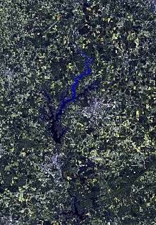
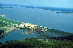
West Point Lake is a man-made reservoir impounded by the West Point Dam, a dam built by the U.S. Army Corps of Engineers on the Chattahoochee River that provides flood control and hydroelectric power. It also provides a reservoir for water to aid the navigation of the lower Chattahoochee. The reservoir extends for about 35 mi (56 km) along the Chattahoochee River near the Alabama-Georgia state boundary.
West Point Lake also contains recreational areas surrounding the lake. The east bank of the lake includes recreational areas such as R. Shaefer Heard Park[1] and Long Cane Park, which contains a boat launching area hidden deep in the woods west of US 29.[2] This park is named for the former unincorporated community which today consists only of intersections with US 29 at Gabbettville Road and Lower Glass Bridge Road, including a local gas station/bait and tackle shop. Parklands on the Lower Glass Bridge Road side of the lake include Maple Creek Park, Potts Road Park and the Earl Cook Access area. The north end of the lake along Georgia State Route 109 includes the proposed Wehalkee Service Area, the Whitetail Ridge Campground, Horace King Access area and Pyne Road Park.
On the west bank in Alabama, recreation areas surround Chambers CR 212 and consist of the Hardley Creek Recreation Area, West Overlook Area, Burnt Village Park, West Lake Recreation Area, all of which are officially addressed as being in Lanett. Amity Park and the Amity Campground can be accessed along CR 394. The northwest side of the lake includes Veasey Creek Recreation Area, which can only be accessed from Chambers CRs 264 and 463 and Oakland Park which can only be accessed along Chambers CR 263.
References
External links
- West Point Lake - US Army Corps of Engineers
- West Point Lake News, Information, Lake Levels, Weather and more