Withlacoochee River (Florida)
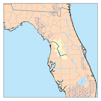
The Withlacoochee River (or Crooked River) originates in central Florida's Green Swamp, east of Polk City. It flows west, then north, and then turns northwest and finally west again before it empties into the Gulf of Mexico near Yankeetown. The river is 141 miles (227 km) long[1] and has a drainage basin of 1,170 square miles (3,000 km2). It is believed to have been named after the Withlacoochee River to the north.
Along its route are the 46-mile-long (74 km) Withlacoochee State Trail, the longest paved rail trail in Florida,[2] the Cypress Lake Preserve, a 324-acre (1.31 km2) park with approximately 600 feet (180 m) of frontage,[3] and Nobleton Wayside Park, a 2-acre (8,100 m2) park in Nobleton that includes a boat ramp, shelter, basketball court, and picnic tables.
The Withlacoochee River flows through Pasco and Hernando counties, and then forms part of the boundary between Hernando County and Sumter County, and all of the boundary between Citrus County and Sumter County, between Citrus County and Marion County and between Citrus County and Levy County (including Lake Rousseau). The largest city close to the river is Dade City.
Etymology
"Withlacoochee" probably stems from a Muskhogean dialect, which suggests that its application is comparatively recent. It is compounded of Creek we (water), thlako (big), and chee (little), or little big water. This word combination signifies little river in the Creek language, and as we-lako or wethlako may also refer to a lake, it may signify a river of lakes, or lake river. The Withlacoochee flows just to the eastward of Tsala Apopka Lake, and the St. Johns River which flows through a series of large and small lakes was called welaka by the Seminoles.[4] Withlacoochee is an Indian word meaning "crooked river" which accurately describes the river as it makes its 70-mile journey from the Green Swamp in northern Polk County to the Gulf of Mexico at Yankeetown.[5]
List of crossings


.JPG)

.JPG)


See also
References
- ↑ U.S. Geological Survey. National Hydrography Dataset high-resolution flowline data. The National Map, accessed April 18, 2011
- ↑ Withlacoochee State Trail (Florida Greenways and Trails)
- ↑ Hernando Parks
- ↑ Simpson, J. Clarence (1956). Mark F. Boyd, ed. Florida Place-Names of Indian Derivation. Tallahassee, Florida: Florida Geological Survey.
- ↑ http://www.freshfromflorida.com/Divisions-Offices/Florida-Forest-Service/Our-Forests/State-Forests/Withlacoochee-State-Forest
Further reading
- Henderson, Rex. 1990. Withlacoochee River. in Marth, Del and Marty Marth, eds. The Rivers of Florida. Sarasota, Florida: Pineapple Press, Inc. ISBN 0-910923-70-1.
External links
- Withlacoochee South Paddling Trail and Withlacoochee North Paddling Trail from the Florida Department of Environmental Protection
| Wikimedia Commons has media related to Withlacoochee River (Central Florida). |