Bull Sluice Lake
| Bull Sluice Lake | |
|---|---|
 Bull Sluice Lake | |
| Location | Fulton / Cobb counties, Georgia[1] |
| Coordinates | 33°58′01″N 84°22′52″W / 33.967°N 84.381°WCoordinates: 33°58′01″N 84°22′52″W / 33.967°N 84.381°W |
| Primary inflows | Chattahoochee River |
| Primary outflows | Chattahoochee River |
| Basin countries | United States |
| Surface area | 673.6 acres (272.6 ha) |
| Average depth | 27 ft (8 m) |
| Max. depth | 55 ft (17 m) |
| Surface elevation | 797 feet (243 m) |
| Settlements | Roswell, Georgia |
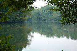
Bull Sluice Lake is a small reservoir located along the Chattahoochee River in northern Georgia, in the northern suburbs of metro Atlanta. It is 673 acres (272 ha), and is impounded by the Morgan Falls Dam. Besides the hydroelectric power produced by the dam, the lake's primary use is recreation, including fishing and rowing.
The term "Bull Sluice", so named by Cherokee Indians, originally was a shoal on the Chattahoochee River.[2]
References
- ↑ U.S. Geological Survey Geographic Names Information System: Bull Sluice Lake
- ↑ Krakow, Kenneth K. (1975). Georgia Place-Names: Their History and Origins (PDF). Macon, GA: Winship Press. p. 28. ISBN 0-915430-00-2.
External links
- Georgia DNR's Bull Sluice Lake Page
- U.S. Geological Survey Geographic Names Information System: Bull Sluice Lake
This article is issued from
Wikipedia.
The text is licensed under Creative Commons - Attribution - Sharealike.
Additional terms may apply for the media files.