Sallèles-d'Aude
| Sallèles-d'Aude | ||
|---|---|---|
| Commune | ||
 | ||
| ||
 Sallèles-d'Aude Location within Occitanie region  Sallèles-d'Aude | ||
| Coordinates: 43°15′36″N 2°56′48″E / 43.26°N 2.9467°ECoordinates: 43°15′36″N 2°56′48″E / 43.26°N 2.9467°E | ||
| Country | France | |
| Region | Occitanie | |
| Department | Aude | |
| Arrondissement | Narbonne | |
| Canton | Le Sud-Minervois | |
| Intercommunality | Canal du Midi en Minervois | |
| Government | ||
| • Mayor (2008–2014) | Yves Bastie | |
| Area1 | 12.55 km2 (4.85 sq mi) | |
| Population (2008)2 | 2,375 | |
| • Density | 190/km2 (490/sq mi) | |
| Time zone | UTC+1 (CET) | |
| • Summer (DST) | UTC+2 (CEST) | |
| INSEE/Postal code | 11369 /11590 | |
| Elevation |
8–46 m (26–151 ft) (avg. 18 m or 59 ft) | |
|
1 French Land Register data, which excludes lakes, ponds, glaciers > 1 km2 (0.386 sq mi or 247 acres) and river estuaries. 2 Population without double counting: residents of multiple communes (e.g., students and military personnel) only counted once. | ||
.svg.png)
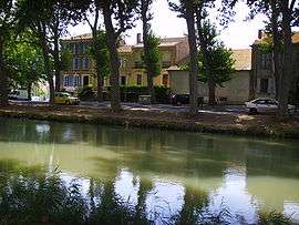
Sallèles-d'Aude is a commune in the Aude department in southern France. The Canal de Jonction, part of the La Nouvelle branch of the Canal du Midi, runs through the middle of the town.
.JPG)
Canal de Jonction at Sallèles d'Aude
Population
| Historical population | ||
|---|---|---|
| Year | Pop. | ±% |
| 1962 | 1,634 | — |
| 1968 | 1,801 | +10.2% |
| 1975 | 1,879 | +4.3% |
| 1982 | 1,842 | −2.0% |
| 1990 | 1,659 | −9.9% |
| 1999 | 1,835 | +10.6% |
| 2008 | 2,375 | +29.4% |
See also
References
External links
| Wikimedia Commons has media related to Sallèles-d'Aude. |
This article is issued from
Wikipedia.
The text is licensed under Creative Commons - Attribution - Sharealike.
Additional terms may apply for the media files.