Saint-Jean-d'Assé
| Saint-Jean-d'Assé | |
|---|---|
| Commune | |
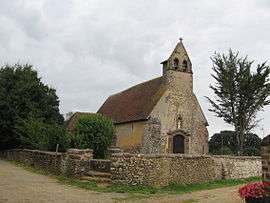 The chapel of Notre-Dame des Champs, in Saint-Jean-d'Assé | |
 Saint-Jean-d'Assé Location within Pays de la Loire region  Saint-Jean-d'Assé | |
| Coordinates: 48°09′05″N 0°07′17″E / 48.1514°N 0.1214°ECoordinates: 48°09′05″N 0°07′17″E / 48.1514°N 0.1214°E | |
| Country | France |
| Region | Pays de la Loire |
| Department | Sarthe |
| Arrondissement | Le Mans |
| Canton | Bonnétable |
| Intercommunality | Communauté de communes des Portes du Maine |
| Government | |
| • Mayor (2008–2014) | Jacques Surmont |
| Area1 | 21.29 km2 (8.22 sq mi) |
| Population (2006)2 | 1,326 |
| • Density | 62/km2 (160/sq mi) |
| Time zone | UTC+1 (CET) |
| • Summer (DST) | UTC+2 (CEST) |
| INSEE/Postal code | 72290 /72380 |
| Elevation | 51–135 m (167–443 ft) |
|
1 French Land Register data, which excludes lakes, ponds, glaciers > 1 km2 (0.386 sq mi or 247 acres) and river estuaries. 2 Population without double counting: residents of multiple communes (e.g., students and military personnel) only counted once. | |
Saint-Jean-d'Assé is a commune in the Sarthe department in the region of Pays-de-la-Loire in north-western France.
See also
References
| Wikimedia Commons has media related to Saint-Jean-d'Assé. |
This article is issued from
Wikipedia.
The text is licensed under Creative Commons - Attribution - Sharealike.
Additional terms may apply for the media files.