Rensselaer, Indiana
| Rensselaer, Indiana | |
|---|---|
| City | |
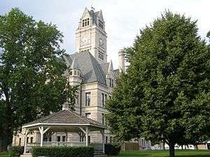 Jasper County Courthouse | |
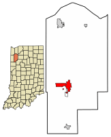 Location of Rensselaer in Jasper County, Indiana | |
| Coordinates: 40°56′17″N 87°9′5″W / 40.93806°N 87.15139°WCoordinates: 40°56′17″N 87°9′5″W / 40.93806°N 87.15139°W | |
| Country | United States |
| State | Indiana |
| County | Jasper |
| Townships | Marion, Newton |
| Platted | June 12, 1839 |
| Incorporated | December 8, 1858 |
| Named for | James Van Rensselaer |
| Government | |
| • Mayor | Stephen A. Wood (D) |
| Area[1] | |
| • Total | 6.64 sq mi (17.19 km2) |
| • Land | 6.58 sq mi (17.04 km2) |
| • Water | 0.06 sq mi (0.16 km2) |
| Elevation | 659 ft (201 m) |
| Population (2010)[2] | |
| • Total | 5,859 |
| • Estimate (2016)[3] | 5,902 |
| • Density | 897.10/sq mi (346.39/km2) |
| Time zone | UTC-6 (CST) |
| • Summer (DST) | UTC-5 (CDT) |
| ZIP code | 47978 |
| Area code(s) | 219 |
| FIPS code | 18-63792[4] |
| GNIS feature ID | 0441902[5] |
| Website |
cityofrensselaerin |
Rensselaer is a city located along the Iroquois River in Marion Township, Jasper County, Indiana, United States. The population was 5,859 at the 2010 census,[6] up from 5,294 at the 2000 census. The city is the county seat of Jasper County.[7] Saint Joseph's College, which closed in 2017, was located just south of the city limits.
Geography
Rensselaer is located southwest of the center of Jasper County at 40°56′17″N 87°9′5″W / 40.93806°N 87.15139°W (40.938051, -87.151341).[8] It is bordered to the south by the unincorporated community of Collegeville, home to the now-closed Saint Joseph's College. The Iroquois River, a tributary of the Kankakee River and hence part of the Illinois River watershed, flows from east to west through the south part of the city.
U.S. Route 231 and Indiana State Road 114 intersect in the downtown area. US-231 leads north 20 miles (32 km) to DeMotte and south 12 miles (19 km) to Remington, while State Road 114 leads east 13 miles (21 km) to U.S. Route 421 and west 3.5 miles (5.6 km) to Interstate 65. Via I-65, Rensselaer is 42 miles (68 km) north of Lafayette and 54 miles (87 km) south of Gary.
According to the 2010 census, Rensselaer has a total area of 3.86 square miles (10.00 km2), of which 3.8 square miles (9.84 km2) (or 98.45%) is land and 0.06 square miles (0.16 km2) (or 1.55%) is water.[9]
History

This settlement, first platted on June 12, 1839, was originally named "Newton" and was established at the rapids of the Iroquois River. By 1844, it had been renamed "Rensselaer", after James Van Rensselaer, a merchant from Utica, New York, who came to the area after his business failed in the Panic of 1837. He took over the land from Joseph D. Yeoman, who had established a farm some years earlier and had begun to plan the village.[10]
St. Joseph Indian Normal School was established in 1888 by St. Katherine Drexel, an heiress from Philadelphia, who donated $50,000 for the education of Catholic American Indian boys. The school trained 60 boys annually until 1896. The school was operated by the Bureau of Catholic Indian Missions.
In addition to St. Joseph Indian Normal School, the Jasper County Courthouse, Oren F. and Adelia Parker House, Rensselaer Carnegie Library, and Rensselaer Courthouse Square Historic District are listed on the National Register of Historic Places.[11][12][13]
| Historical population | |||
|---|---|---|---|
| Census | Pop. | %± | |
| 1850 | 241 | — | |
| 1860 | 535 | 122.0% | |
| 1870 | 617 | 15.3% | |
| 1880 | 968 | 56.9% | |
| 1890 | 1,455 | 50.3% | |
| 1900 | 2,255 | 55.0% | |
| 1910 | 2,393 | 6.1% | |
| 1920 | 2,912 | 21.7% | |
| 1930 | 2,798 | −3.9% | |
| 1940 | 3,214 | 14.9% | |
| 1950 | 4,072 | 26.7% | |
| 1960 | 4,740 | 16.4% | |
| 1970 | 4,688 | −1.1% | |
| 1980 | 4,944 | 5.5% | |
| 1990 | 5,045 | 2.0% | |
| 2000 | 5,294 | 4.9% | |
| 2010 | 5,859 | 10.7% | |
| Est. 2016 | 5,902 | [3] | 0.7% |
| U.S. Decennial Census[14] | |||
Demographics
2010 census
As of the census[2] of 2010, there were 5,859 people, 2,336 households, and 1,517 families residing in the city. The population density was 1,541.8 inhabitants per square mile (595.3/km2). There were 2,556 housing units at an average density of 672.6 per square mile (259.7/km2). The racial makeup of the city was 95.4% White, 0.7% African American, 0.4% Native American, 0.4% Asian, 0.1% Pacific Islander, 1.8% from other races, and 1.3% from two or more races. Hispanic or Latino of any race were 5.4% of the population.
There were 2,336 households of which 33.4% had children under the age of 18 living with them, 44.9% were married couples living together, 14.7% had a female householder with no husband present, 5.4% had a male householder with no wife present, and 35.1% were non-families. 29.5% of all households were made up of individuals and 12.6% had someone living alone who was 65 years of age or older. The average household size was 2.42 and the average family size was 2.96.
The median age in the city was 36.6 years. 25.5% of residents were under the age of 18; 8.7% were between the ages of 18 and 24; 25.6% were from 25 to 44; 23.7% were from 45 to 64; and 16.4% were 65 years of age or older. The gender makeup of the city was 48.0% male and 52.0% female.
2000 census
As of the census[4] of 2000, there were 5,294 people, 2,158 households, and 1,404 families residing in the city. The population density was 1,824.8 people per square mile (704.8/km²). There were 2,296 housing units at an average density of 791.4 per square mile (305.7/km²). The racial makeup of the city was 97.94% White, 0.32% African American, 0.21% Native American, 0.09% Asian, 0.66% from other races, and 0.77% from two or more races. Hispanic or Latino of any race were 2.53% of the population.
There were 2,158 households out of which 31.2% had children under the age of 18 living with them, 50.1% were married couples living together, 10.8% had a female householder with no husband present, and 34.9% were non-families. 31.1% of all households were made up of individuals and 15.6% had someone living alone who was 65 years of age or older. The average household size was 2.37 and the average family size was 2.98.
In the city, the population was spread out with 25.3% under the age of 18, 9.4% from 18 to 24, 26.9% from 25 to 44, 20.0% from 45 to 64, and 18.5% who were 65 years of age or older. The median age was 36 years. For every 100 females, there were 89.0 males. For every 100 females age 18 and over, there were 83.4 males.
The median income for a household in the city was $34,821, and the median income for a family was $43,313. Males had a median income of $33,971 versus $24,016 for females. The per capita income for the city was $20,872. About 6.6% of families and 10.0% of the population were below the poverty line, including 11.8% of those under age 18 and 8.0% of those age 65 or over.
Climate
Humid continental climate is a climatic region typified by large seasonal temperature differences, with warm to hot (and often humid) summers and cold (sometimes severely cold) winters. Precipitation is relatively well distributed year-round in many areas with this climate, while others may see a marked reduction in wintry precipitation and even a wintertime drought. The Köppen Climate Classification subtype for this climate is "Dfa". (Hot Summer Continental Climate).[15]
Education
Rensselaer has a public library, a branch of the Jasper County Public Library.[16]
Notable people
- Eleanor Stackhouse Atkinson, author
- Dan Brandenburg, National Football League player, Buffalo Bills 1996-1999[17]
- Charles A. Halleck, Republican leader of the United States House of Representatives
- James Frederick "Jimmy" Hanley, American songwriter
- Tom Harmon, 1940 Heisman Trophy winner
- Augustus Phillips, actor during the silent film era
References
- ↑ "2016 U.S. Gazetteer Files". United States Census Bureau. Retrieved Jul 28, 2017.
- 1 2 "American FactFinder". United States Census Bureau. Retrieved 2012-12-11.
- 1 2 "Population and Housing Unit Estimates". Retrieved June 9, 2017.
- 1 2 "American FactFinder". United States Census Bureau. Retrieved 2008-01-31.
- ↑ "US Board on Geographic Names". United States Geological Survey. 2007-10-25. Retrieved 2008-01-31.
- ↑ "Geographic Identifiers: 2010 Census Summary File 1 (G001): Rensselaer city, Indiana". American Factfinder. U.S. Census Bureau. Retrieved May 15, 2018.
- ↑ "Find a County". National Association of Counties. Retrieved 2011-06-07.
- ↑ "US Gazetteer files: 2010, 2000, and 1990". United States Census Bureau. 2011-02-12. Retrieved 2011-04-23.
- ↑ "G001 - Geographic Identifiers - 2010 Census Summary File 1". United States Census Bureau. Retrieved 2015-07-29.
- ↑ Battle, J. H. (1883). "History of Jasper County". Counties of Warren, Benton, Jasper, and Newton, Indiana. Chicago, Illinois: F. A. Battey and Company. pp. 508–514.
- ↑ National Park Service (2010-07-09). "National Register Information System". National Register of Historic Places. National Park Service.
- ↑ "National Register of Historic Places Listings". Weekly List of Actions Taken on Properties: 4/09/12 through 4/13/12. National Park Service. 2012-04-20.
- ↑ "National Register of Historic Places Listings". Weekly List of Actions Taken on Properties: 9/29/14 through 10/03/14. National Park Service. 2014-10-10.
- ↑ "Census of Population and Housing". Census.gov. Retrieved June 4, 2015.
- ↑ Climate Summary for Rensselaer, Indiana
- ↑ "Rensselaer Public Library, Headquarters". Jasper County Public Library. Retrieved 8 March 2018.
- ↑ Dan Brandenburg, LB at NFL.com
External links
| Wikisource has the text of a 1920 Encyclopedia Americana article about Rensselaer, Indiana. |
Municipalities and communities of Jasper County, Indiana, United States | ||
|---|---|---|
| City | ||
| Towns | ||
| Townships | ||
| CDPs | ||
| Other unincorporated communities | ||
| Footnotes | ‡This populated place also has portions in an adjacent county or counties | |