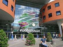
Amersfoort
| Amersfoort | |||
|---|---|---|---|
| City and municipality | |||
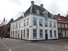
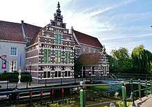
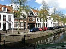
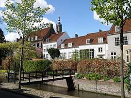 .jpg) .jpg)  Images, from top down, left to right: Zuidsingel, Het Hoef, Lieve Vrouwekerkhof and Woudzoom | |||
| |||
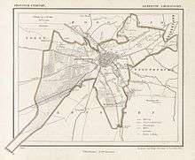
.svg.png) Location in Utrecht | |||
| Coordinates: 52°9′N 5°23′E / 52.150°N 5.383°ECoordinates: 52°9′N 5°23′E / 52.150°N 5.383°E | |||
| Country | Netherlands | ||
| Province |
| ||
| City rights | 1259 | ||
| Government[1] | |||
| • Body | Municipal council | ||
| • Mayor | Lucas Bolsius (CDA) | ||
| Area[2] | |||
| • Municipality | 63.86 km2 (24.66 sq mi) | ||
| • Land | 62.86 km2 (24.27 sq mi) | ||
| • Water | 1.00 km2 (0.39 sq mi) | ||
| Elevation[3] | 3 m (10 ft) | ||
| Population (Municipality, August 2017; Urban and Metro, May 2014)[4][5] | |||
| • Municipality | 155,089 | ||
| • Density | 2,467/km2 (6,390/sq mi) | ||
| • Urban | 180,539 | ||
| • Metro | 287,110 | ||
| Demonym(s) | Amersfoorter(s) | ||
| Time zone | UTC+1 (CET) | ||
| • Summer (DST) | UTC+2 (CEST) | ||
| Postcode | 3800–3829 | ||
| Area code | 033 | ||
| Website |
www | ||


Amersfoort [ˈaːmərsfoːrt] (![]()
Population centres
The municipality of Amersfoort consists of the following cities, towns, villages and districts: Bergkwartier, Bosgebied, Binnenstad, Hoogland, Hoogland-West, Kattenbroek, Kruiskamp, de Koppel, Liendert, Rustenburg, Nieuwland, Randenbroek, Schuilenburg, Schothorst, Soesterkwartier, Vathorst, Hooglanderveen, Vermeerkwartier, Leusderkwartier, Zielhorst and Stoutenburg-Noord.
History
Hunter gatherers set up camps in the Amersfoort region in the Mesolithic period. Archaeologists have found traces of these camps, such as the remains of hearths, and sometimes microlithic flint objects, to the north of the city.
Early years
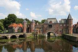

Remains of settlements in the Amersfoort area from around 1000 BC have been found, but the name Amersfoort, after a ford in the Amer River, today called the Eem, did not appear until the 11th century. The city grew around what is now known as the central square, the Hof, where the Bishops of Utrecht established a court in order to control the "Gelderse Vallei" area. It was granted city rights in 1259 by the bishop of Utrecht, Henry I van Vianden. A first defensive wall, made out of brick, was finished around 1300. Soon after, the need for enlargement of the city became apparent and around 1380 the construction of a new wall was begun and completed around 1450. The famous Koppelpoort, a combined land and water gate, is part of this second wall. The first wall was demolished and houses were built in its place. Today's Muurhuizen (wallhouses) Street is at the exact location of the first wall; the fronts of the houses are built on top of the first city wall's foundations.
The Onze-Lieve-Vrouwentoren (Tower of Our Lady)[7] is one of the tallest medieval church towers in the Netherlands at 98 metres (322 ft).
The construction of the tower and the church was started in 1444. The church was destroyed by an explosion in 1787, but the tower survived, and the layout of the church still can be discerned today through the use of different types of stone in the pavement of the open space that was created. It is now the reference point of the RD coordinate system, the coordinate grid used by the Dutch topographical service: the RD coordinates are (155.000, 463.000).
The inner city of Amersfoort has been preserved well since the Middle Ages. Apart from the Onze-Lieve-Vrouwetoren, the Koppelpoort, and the Muurhuizen (Wall-houses), there is also the Sint-Joriskerk (Saint George's church), the canal-system with its bridges, as well as medieval and other old buildings; many are designated as national monuments. In the Middle Ages, Amersfoort was an important centre for the textile industry, and there were a large number of breweries. Jews also lived in Amersfoort in the Middle Ages, before being expelled from the province in 1546 and beginning to return to the city in 1655.[8]
Origin of the Keistad
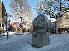
The nickname for Amersfoort, Keistad (boulder-city), originates in the Amersfoortse Kei, a 9-tonne (19,842 lb) boulder that was dragged from the Soest moors into the city in 1661 by 400 people because of a bet between two landowners. The people got their reward when the winner bought everyone beer and pretzels. Other nearby towns then nicknamed the people of Amersfoort Keientrekker (boulder-puller). This story embarrassed the inhabitants, and they buried the boulder in the city in 1672, but after it was found again in 1903 it was placed in a prominent spot as a monument. There are not many boulders in the Netherlands, so it can be regarded as an icon.
Nieuw Amersfoort
One of the six Dutch towns established in the 17th Century in what is now Brooklyn was called "Nieuw Amersfoort" (New Amersfoort). The original patentees were Wolfert Gerritse van Kouwenhoven and Andries Hudde.[9] Unlike other Dutch names which were retained up to the present, Nieuw Amersfoort is now called "Flatlands".
In the 18th century the city flourished because of the cultivation of tobacco,[note 1] but from about 1800 onwards began to decline.
The decline was halted by the establishment of the first railway connection in 1863, and, some years later, by the building of a substantial number of infantry and cavalry barracks, which were needed to defend the western cities of the Netherlands.
After the 1920s growth stalled again, until in 1970 the national government designated Amersfoort, then numbering some 70,000 inhabitants, as a "growth city".
Second World War

Since Amersfoort was the largest garrison town in the Netherlands before the outbreak of the Second World War, with eight barracks, and part of the main line of defence, the whole population of then 43,000 was evacuated ahead of the expected invasion by the Germans in May 1940. After four days of battle, the population was allowed to return.
There was a functioning Jewish community in the town, at the beginning of the war numbering about 700 people. Half of them were deported and killed, mainly in Auschwitz and Sobibor. In 1943, the synagogue, dating from 1727, was severely damaged on the orders of the then Nazi-controlled city government. It was restored and opened again after the war, and has been served since by a succession of rabbis.
There was a Nazi concentration camp near the city of Amersfoort during the war. The camp, officially called Polizeiliches Durchgangslager Amersfoort (Police Transit Camp Amersfoort), better known as Kamp Amersfoort, was actually located in the neighbouring municipality of Leusden.
After the war the leader of the camp, Joseph Kotälla, served a life sentence in prison. He died in captivity in 1979. Some of the victims of the camp are buried in Rusthof cemetery near the town.
Among the victims were prisoners of war from the Soviet Union, including 101 Central Asians, mostly Uzbeks or citizens of Samarqand. Locals would commemorate them, but the identity of the 101 soldiers was not known, until journalist Remco Reiding started investigating this case in 1999, after hearing about the cemetery. Amongst the few remaining people who witnessed the 101 soldiers is Henk Broekhuizen.[10][11]
Culture
Museums
.jpg)
- The Mondriaan House: birthplace of the painter Piet Mondriaan. Exhibits a lifesize reconstruction of his workshop in Paris. Some temporary shows and work by artists inspired by the painter.
- Flehite: historic, educational and temporary exhibitions behind a splendid facade. The museum closed in 2007 due to asbestos contamination. It was refurbished and reopened in May 2009.
- Zonnehof: small elegant modernist building designed by Gerrit Rietveld on an eponymous square just south of the centre with temporary exhibitions of mostly contemporary art.(closed)
- Armanda Museum: work by the painter Armando who lived in Amersfoort as a child in a renovated church building. Most of the church and the art on exhibition was destroyed in a fire on 22 October 2007.[12]
- Dutch Cavalry Museum: museum in 475 years old barracks. Most other military museums in the Netherlands got absorbed into the National Military Museum (Nationaal Militair Museum), but the cavalry museum has stood strong. It shows Dutch cavalry and tanks.
- Culinary Museum (was closed in 2006).
- Kunsthal KAdE:[13] a modern art exhibition hall.
Sports
Amersfoort had its own professional football (soccer) club named HVC Amersfoort. It was founded on 30 July 1973, but disbanded on 30 June 1982 because of financial problems. The city also hosted the riding part of the modern pentathlon event for the 1928 Summer Olympics.[14] Amersfoort also hosted the Dutch Open (tennis) tournament from 2002 till its end in 2008.
Other
The city has a zoo, DierenPark Amersfoort, which was founded in 1948. Amersfoort is the greenest city in the Netherlands.
Transport
Bus
Bus services are provided by 2 firms: U-OV and Syntus. Syntus provides services in town and the entirety of the province Utrecht, save for the bus to the city Utrecht, which is provided by U-OV.
Rail
Amersfoort has three railway stations:
- Amersfoort, the main station, which has trains to Utrecht, Zwolle, Enschede, Rotterdam, The Hague, Amsterdam, Schiphol, Leeuwarden Groningen Ede-Wageningen and Berlin
- Amersfoort Schothorst, to the north of Amersfoort station.
- Amersfoort Vathorst, to the north of Amersfoort Schothorst.
Road
Two major motorways pass Amersfoort:
- along the north, the A1 motorway (Amsterdam–Apeldoorn)
- along the east, the A28 motorway (Utrecht–Groningen)
Water
The river Eem (pronounced roughly "aim") begins in Amersfoort, and the town has a port for inland water transport. The Eem connects to the nearby Eemmeer (Lake Eem). The Valleikanaal drains the eastern Gelderse Vallei and joins with other sources to form the Eem in Amersfoort.
Local government
The municipal council of Amersfoort consists of 39 seats, which are divided as follows:[15][16]
- VVD – 5 seats (6 seats in 2010)
- PvdA – 5 seats (6 seats in 2010)
- CDA – 4 seats (4 seats in 2010)
- GroenLinks – 3 seats (5 seats in 2010)
- ChristenUnie – 5 seats (10 seats in 2010)
- SP – 4 seats (2 seats in 2010)
- D'66 – 9 seats (5 seats in 2010)
- Burger Partij Amersfoort – 2 seats (7 seats in 2010)
- Amersfoort2014 – 1 seat (not represented in 2010)
- OPA – 1 seat (not represented in 2010)
The city has a court of first instance (kantongerecht) and a regional chamber of commerce.
Economy
The city is a main location for several international companies:
- Royal VolkerWessels Stevin N.V., a major European construction-services business.
- FrieslandCampina, a Dutch dairy cooperative.
- Royal HaskoningDHV, consultants and engineers.
- Golden Tulip Hospitality Group, international hotel chain Golden Tulip Hotels, Inns and Resorts.[17]
- Nutreco, animal feed and human foodstuffs
- Yokogawa Electric, an electrical engineering and software company, the European headquarters for which are located in Amersfoort
It also has a number of non-governmental organizations and foundations:
- Christian Union, a Christian democratic political party in the Netherlands.
- Oikocredit, headquarters of global cooperative society, financing economic development focused on poverty alleviation.
- Socialist Party, a left-wing social-democratic political party in The Netherlands.
- KNLTB, the Dutch national lawn-tennis association.
- Vereniging Eigen Huis, the largest home-owners association in the Netherlands; with 700,000 members, it is also the largest in the world
Notable residents

- Paulus Buys (1531–1594) – Grand Pensionary
- Johan van Oldenbarnevelt (1547–1619) – statesman
- Piet Mondriaan (1872–1944) – painter
- Willem Sandberg (1897–1984) – graphic designer, Stedelijk Museum director
- Ben Pon (1936) – sports car racing driver
- Ben Pon (senior) – car importer and developer of the Volkswagen Type 2
- Loet Geutjes (1943) – water polo player
- Feike de Vries (1943) – water polo player
- Paul Cobben (1951) – philosopher
- Anke Rijnders (1956) – swimmer
- Frank Drost (1963) – swimmer
- Jan Wagenaar (1965) – water polo player
- Arie van de Bunt (1969) – water polo goalkeeper
- Johannes Heesters (1903–2011) – actor and singer
- Ton van Heugten (1945–2008) – former sidecarcross world champion
- Victor Kaisiepo (1948–2010) – advocate for West Papuan self-determination.[18]
- Jeff de Neeling, Football player
- Joop Kasteel, Professional Fighter and Bodybuilder
- Valentijn Overeem, mixed martial artist
- Alistair Overeem, mixed martial artist & kickboxer
- Father Roderick Vonhögen, – television host, podcaster, founder of the Star Quest Production Network
- Gino Vannelli (1952), Canadian singer, songwriter, musician and composer
- Marco van Ginkel (1992), Dutch football player for Milan & the Netherlands national team
- Blaudzun (1974) – singer and filmmaker, stage name of Johannes Sigmond[19]
- Curt Wolters (1938), American diplomat
Sister city
See also
References
- ↑ "Burgemeester" [Mayor] (in Dutch). Gemeente Amersfoort. Archived from the original on 16 July 2014. Retrieved 3 April 2014.
- ↑ "Kerncijfers wijken en buurten" [Key figures for neighbourhoods]. CBS Statline (in Dutch). CBS. 2 July 2013. Retrieved 12 March 2014.
- ↑ "Postcodetool for 3811LM". Actueel Hoogtebestand Nederland (in Dutch). Het Waterschapshuis. Archived from the original on 21 September 2013. Retrieved 3 April 2014.
- ↑ "Bevolkingsontwikkeling; regio per maand" [Population growth; regions per month]. CBS Statline (in Dutch). CBS. 27 October 2017. Retrieved 27 October 2017.
- ↑ "Bevolkingsontwikkeling; regio per maand" [Population growth; regions per month]. CBS Statline (in Dutch). CBS. 26 June 2014. Retrieved 24 July 2014.
- ↑ "Home Page" (in Dutch). Amersfoort 750. Archived from the original on 2 February 2009. Retrieved 24 January 2009.
- ↑ "Onze Lieve Vrouwentoren". SkyscraperCity. Archived from the original on 28 September 2007. Retrieved 26 March 2008.
- ↑ "The Jewish Community of Amersfoort". The Museum of the Jewish People at Beit Hatfutsot.
- ↑ Kilgannon, Corey (2007-11-01). "Dutch Deed Fetches More Than a Handful of Beads". City Room. Retrieved 2018-05-16.
- ↑ "Soviet Field of Glory" (in Russian)
- ↑ Rustam Qobil (9 May 2017). "Why were 101 Uzbeks killed in the Netherlands in 1942?". BBC. Retrieved 9 May 2017.
- ↑ "Armando Museum fire". Armandomuseum.nl. 22 October 2007. Archived from the original on 11 November 2007. Retrieved 4 November 2007.
- ↑ Kunsthalkade.nl
- ↑ van Rossem, George, ed. (1931). The ninth Olympiad, being the official report of the Olympic games of 1928 celebrated at Amsterdam (PDF). Translated by Sydney W. Fleming. Amsterdam: Netherlands Olympic Committee (Committee 1928); J.H. de Bussy. p. 277. OCLC 10243706. Archived from the original (PDF) on 8 April 2008.
- ↑ "Zetelverdeling en stemaantallen" (in Dutch). Gemeente Amersfoort. Archived from the original on 28 September 2007. Retrieved 26 March 2008.
- ↑ "Verkiezingsuitslag(stemaantalen en zetelverdeling 3 maart 2010" (in Dutch). Gemeente Amersfoort. Archived from the original on 12 April 2010. Retrieved 26 April 2010.
- ↑ "Contact". Golden Tulip Hospitality Group. Archived from the original on 12 September 2010. Retrieved 27 June 2010.
- ↑ "Papuan activist Kaisiëpo dies". Radio Netherlands Worldwide. 31 January 2010. Retrieved 20 February 2010.
- ↑ "Blaudzun" (in Dutch). Muziek Encyclopedie. Retrieved 23 June 2014.
Notes
- ↑ The Russian word for the tobacco Nicotiana rustica, махорка (makhorka), may bear an etymological debt to this city. See the dictionary of Max Vasmer.
External links


- Official website
Places adjacent to Amersfoort | |
|---|---|
Municipalities of Utrecht | ||
|---|---|---|
 | ||
| ||