A1 motorway (Netherlands)
| |
|---|---|
| Rijksweg 1 | |
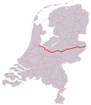 Location of the A1 motorway | |
| Route information | |
|
Part of | |
| Maintained by Rijkswaterstaat[1] | |
| Length | 119 km[2] (74 mi) |
| Major junctions | |
| West end |
|
| East end |
|
| Location | |
| Provinces | North Holland, Utrecht, Gelderland, Overijssel |
| Highway system | |

The A1 is a motorway in the Netherlands. The road connects the capital city of Amsterdam, near the interchange of Watergraafsmeer, with the German border, near Oldenzaal and Bad Bentheim, and the German Autobahn BAB 30. On its way, it crosses four provinces: North Holland, Utrecht, Gelderland and Overijssel.
European routes
The section of the road between its start at the interchange Watergraafsmeer, and the interchange of Hoevelaken near Amersfoort, is also a European route: the E231. This section of the A1 is the complete E231 route; the E231 does not consist of any other road or section.
Between the interchange Hoevelaken and the German border (and beyond, along the BAB 30), the European route E30 follows the A1 motorway. This European route is a so-called A-Class West-East European route, going from Cork in Ireland all the way to Omsk in Russia.
Exit list
| Country | Province | Municipality | km | mi | Exit | Destinations | Notes |
|---|---|---|---|---|---|---|---|
| Netherlands | North Holland | Amsterdam - Diemen municipality line | — | West end of E 231 overlap | |||
| Diemen | 1 | Landlust / Diemerpolderweg | Westbound entrance and eastbound exit only | ||||
| 2 | |||||||
| — | |||||||
| Muiden | 3 | Maxisweg / Mariahoeveweg / Weesperweg | |||||
| — | |||||||
| Naarden | 5 | Rijksweg / Churchillstraat | Westbound entrance and eastbound exit only | ||||
| 6 | IJsselmeerweg | ||||||
| 7 | Amersfoortsestraatweg | ||||||
| Huizen - Laren - Hilversum municipality line | 8 | ||||||
| Laren | 9 | ||||||
| North Holland - Utrecht province Line | Laren - Eemnes - Baarn municipality line | 10 | |||||
| Utrecht | Baarn | 11 | |||||
| Bunschoten - Amersfoort municipality line | 12 | ||||||
| Amersfoort | 13 | Bergpas / Rondweg Oost | |||||
| — | East end of E 231 overlap; west end of E 30 overlap | ||||||
| 14 | Amersfoortsestraat / Westerdorpsstraat / Nijkerkerstraat | Eastbound exit accessible only from A28 northbound | |||||
| Gelderland | Barneveld | 15 | |||||
| 16 | |||||||
| 17 | |||||||
| Apeldoorn | 18 | ||||||
| 19 | |||||||
| 20 | Kayersdijk | ||||||
| — | |||||||
| 21 | |||||||
| Voorst | 22 | ||||||
| Overijssel | Deventer | 23 | |||||
| 24 | |||||||
| 25 | Marsdijk / Baarhorsterdijk | ||||||
| Rijssen-Holten | 26 | ||||||
| 27 | |||||||
| Wierden | 28 | ||||||
| Borne | — | West end of A35 overlap | |||||
| 29 | Kluft | ||||||
| — | East end of A35 overlap | ||||||
| Hengelo | 30 | Rondweg / Bornestraat | |||||
| 31 | Oldenzaalsestraat / Hasselerbaan | ||||||
| Oldenzaal | 32 | Provinciale rondweg | |||||
| 33 | |||||||
| Losser | 34 | ||||||
| Netherlands - Germany country line | Overijssel - North Rine-Westphalia province line | Losser - Gronau municipality line | — | East end of E 30 overlap | |||
1.000 mi = 1.609 km; 1.000 km = 0.621 mi
| |||||||
References
- ↑ "Wegbeheerders" [Road managers]. Rijkswaterstaat. Retrieved 17 February 2018.
- ↑ "Actuele Wegenlijst RWS" [Up to date road list] (in Dutch). Rijkswaterstaat. 1 July 2015. Retrieved 17 February 2018.
External links
![]()