Leusden
| Leusden | |||
|---|---|---|---|
| Municipality | |||
 From left to right; Highrise building, Park Wildenburg, St. Jozefkerk, Kooikersgracht, Residential tower, Biezenkamp | |||
| |||
.svg.png) Location in Utrecht | |||
| Coordinates: 52°8′N 5°26′E / 52.133°N 5.433°ECoordinates: 52°8′N 5°26′E / 52.133°N 5.433°E | |||
| Country | Netherlands | ||
| Province | Utrecht | ||
| Government[1] | |||
| • Body | Municipal council | ||
| • Mayor | Gerolf Bouwmeester (D66) | ||
| Area[2] | |||
| • Total | 58.89 km2 (22.74 sq mi) | ||
| • Land | 58.63 km2 (22.64 sq mi) | ||
| • Water | 0.26 km2 (0.10 sq mi) | ||
| Elevation[3] | 3 m (10 ft) | ||
| Population (August 2017)[4] | |||
| • Total | 29,762 | ||
| • Density | 508/km2 (1,320/sq mi) | ||
| Demonym(s) | Leusdenaar | ||
| Time zone | UTC+1 (CET) | ||
| • Summer (DST) | UTC+2 (CEST) | ||
| Postcode | 3830–3835 | ||
| Area code | 033 | ||
| Website |
www | ||


Leusden (Dutch pronunciation: [ˈløːzdə(n)] (![]()
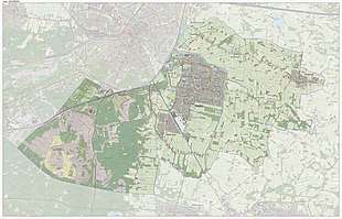
The western part of the municipality lies on the slopes of the Utrecht Hill Ridge and is largely covered by forest and heathlands. The eastern parts lie in the Gelderse Vallei and are mostly agricultural.
Population centres

The municipality of Leusden contains four villages:
- Leusden, originally named "Hamersveld" and later "Leusden-Centrum";
- Leusden-Zuid, formerly "Leusbroek"
- Achterveld
- Stoutenburg
There are also a number of hamlets in the municipality:[5] Asschat, Den Treek, De Ruif, Jannendorp, Musschendorp, Oud-Leusden (formerly named "Leusden"), and Snorrenhoef.
The town of Leusden
The place that is now called Leusden was first mentioned as Villa Lisiduna in a charter in 777. The exact location of that settlement, which is considered to have been a rather extensive farm complex with defenses, is unknown to us. It is possible that the old village of Oud-Leusden once was the location of Villa Lisiduna but excavations in the 1980s have not provided any evidence. However, the church tower of Oud-Leusden is one of the oldest towers in the Netherlands, dating back at least to the 11th century A.D. Close to Leusden is the site of the former monastery Heiligenberg, founded around the year 1000 by bishop Ansfridus of Utrecht, who died here in 1010.
In the 1970s, the agricultural villages of Leusbroek and Hamersveld grew together into a larger, mainly residential town. What once was Hamersveld is now called Leusden-Centrum, now commonly Leusden, and Leusbroek was to become Leusden-Zuid. In the original plans, Leusden was to grow into a town of around 46,000 inhabitants. After the initial expansion there was a growing resistance from the population, so some of the later phases of expansion have been abandoned.
Shopping Areas

In Leusden there are 3 shopping centres:
- The Hamershof, this is the biggest mall with about 80 stores in the centre of Leusden. The oldest part opened in 1980 together with the Town Hall nearby the Hamershof.
- The Biezenkamp, this is the second shopping centre in the centre of town, there are not more than 20 shops.
- And the third shopping centre is the Zuidhoek in the new neighborhood the Tabaksteeg, there are just 5 shops located around the square.
Notable residents
- Robby Valentine (b. 1968), singer and multi-instrumentalist, born in Leusden
- Marieke Wijsman (b. 1975), former speed-skater, born in Leusden
- Marike Jager (b. 1979), singer-songwriter, grew up in Leusden
- Gerrit Achterberg (1905-1962), poet, died in Leusden
- Arleen Auger (1939-1993), soprano, died in Leusden
Image gallery
 Newer part of the city, near a shopping centre
 Old villa in the center
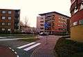 One of the newest parts in the center
 Row of new houses in the centre of Leusden
References
- ↑ "Burgemeester Vermeulen" [Mayor Vermeulen] (in Dutch). Gemeente Leusden. Archived from the original on 13 June 2011. Retrieved 4 April 2014.
- ↑ "Kerncijfers wijken en buurten" [Key figures for neighbourhoods]. CBS Statline (in Dutch). CBS. 2 July 2013. Retrieved 12 March 2014.
- ↑ "Postcodetool for 3831NA". Actueel Hoogtebestand Nederland (in Dutch). Het Waterschapshuis. Archived from the original on 21 September 2013. Retrieved 4 April 2014.
- ↑ "Bevolkingsontwikkeling; regio per maand" [Population growth; regions per month]. CBS Statline (in Dutch). CBS. 27 October 2017. Retrieved 27 October 2017.
- ↑ ANWB, "Topografische atlas Nederland 1:50000", 2005. Cartography by the Topografische Dienst, Emmen.
External links

- Official website
Places adjacent to Leusden | ||||||||||
|---|---|---|---|---|---|---|---|---|---|---|
| ||||||||||
Municipalities of Utrecht | ||
|---|---|---|
 | ||
| ||