IJsselstein
| IJsselstein | |||
|---|---|---|---|
| City and Municipality | |||
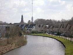 Hollandse IJssel through IJsselstein with church and Gerbrandy Tower in background | |||
| |||
.svg.png) Location in Utrecht | |||
| Coordinates: 52°1′N 5°2′E / 52.017°N 5.033°ECoordinates: 52°1′N 5°2′E / 52.017°N 5.033°E | |||
| Country | Netherlands | ||
| Province | Utrecht | ||
| Government[1] | |||
| • Body | Municipal council | ||
| • Mayor | Patrick van Domburg (VVD) | ||
| Area[2] | |||
| • Total | 21.68 km2 (8.37 sq mi) | ||
| • Land | 21.15 km2 (8.17 sq mi) | ||
| • Water | 0.53 km2 (0.20 sq mi) | ||
| Elevation[3] | 1 m (3 ft) | ||
| Population (August 2017)[4] | |||
| • Total | 34,326 | ||
| • Density | 1,623/km2 (4,200/sq mi) | ||
| Demonym(s) | IJsselsteiner(s) | ||
| Time zone | UTC+1 (CET) | ||
| • Summer (DST) | UTC+2 (CEST) | ||
| Postcode | 3400–3404 | ||
| Area code | 030 | ||
| Website |
www | ||

IJsselstein (Dutch pronunciation: [ˈɛisəlstɛin] (![]()
Sights
The city has an old town, surrounded by a small canal. A castle stood in IJsselstein from 1300 to 1888; the tower survived. The city has two large churches, both named after St. Nicholas: the Dutch Reformed Nicolaas church, founded in 1310, and a Roman Catholic one. Inside the Protestant church there are two mausoleums; one of the family of Gijsbrecht van Amstel (1350) and another one of Aleida van Culemborg (1475). The catholic basilica of St. Nicolaas dates from 1887 and is neo-gothic. It was given the title of 'Basilica Minor' by Pope Paul VI in 1972.
A 366.8 metres high television mast, called the Gerbrandy Tower, is located in IJsselstein. The tower is commonly, and erroneously, referred to as Zendmast Lopik, after the nearby village of Lopik.
Topography
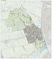 Dutch Topographic map of the municipality of IJsselstein, June 2015
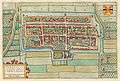 1649 map of IJsselstein in Willem and Joan Blaeu's "Toonneel der Steden"
Gallery
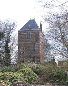 Tower of the former castle.
 Protestant church.
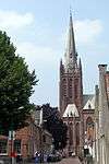 Catholic basilica.
References
- ↑ "Samenstelling" [Members] (in Dutch). Gemeente IJsselstein. Archived from the original on 8 April 2014. Retrieved 7 April 2014.
- ↑ "Kerncijfers wijken en buurten" [Key figures for neighbourhoods]. CBS Statline (in Dutch). CBS. 2 July 2013. Retrieved 12 March 2014.
- ↑ "Postcodetool for 3401BK". Actueel Hoogtebestand Nederland (in Dutch). Het Waterschapshuis. Archived from the original on 21 September 2013. Retrieved 7 April 2014.
- ↑ "Bevolkingsontwikkeling; regio per maand" [Population growth; regions per month]. CBS Statline (in Dutch). CBS. 27 October 2017. Retrieved 27 October 2017.
External links

- Official website
Municipalities of Utrecht | ||
|---|---|---|
 | ||
| ||
| Authority control |
|---|