Quantico, Virginia
| Quantico, Virginia | |
|---|---|
| Town | |
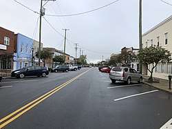 Potomac Avenue in downtown Quantico | |
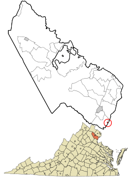 Location in Prince William County and the state of Virginia. | |
| Coordinates: 38°31′19″N 77°17′23″W / 38.52194°N 77.28972°W | |
| Country |
|
| State |
|
| County |
|
| Area | |
| • Total | 0.1 sq mi (0.3 km2) |
| • Land | 0.1 sq mi (0.3 km2) |
| • Water | 0.0 sq mi (0.0 km2) |
| Elevation | 39 ft (12 m) |
| Population (2010) | |
| • Total | 480 |
| Time zone | UTC−5 (Eastern (EST)) |
| • Summer (DST) | UTC−4 (EDT) |
| ZIP code | 22134 |
| Area codes | 571, 703 |
| FIPS code | 51-65120[1] |
| GNIS feature ID | 1499925[2] |
| Website | townofquantico.org |
Quantico (formerly Potomac)[3] is a town in Prince William County, Virginia, United States. The population was 480 at the 2010 census.
Quantico is located just northwest of the Potomac River and just south of the Quantico Creek. The word Quantico is a derivation of the name of a Doeg village recorded by English colonists as Pamacocack.
Quantico is surrounded on three sides by one of the largest U.S. Marine Corps bases, Marine Corps Base Quantico. The base is the site of the Marine Corps Combat Development Command and HMX-1 (the presidential helicopter squadron), Officer Candidate School, and The Basic School. The United States Drug Enforcement Administration's training academy, the FBI Academy, the FBI Laboratory, the Naval Criminal Investigative Service, the United States Army Criminal Investigation Command, and the Air Force Office of Special Investigations headquarters are on the base. A replica of the USMC War Memorial stands at the entrance to the base.
As of 2013, the mayor is Kevin P. Brown.[4]
Geography
Quantico is at 38°31'19" North, 77°17'23" West (38.521871, −77.289757).[5] According to the United States Census Bureau, the town has a total area of 0.1 square miles (0.3 km2), of which, 0.1 square miles (0.3 km2) of it is land and none of the area is covered with water.
Climate
Quantico has a humid subtropical climate (Köppen climate classification Cfa).
| Climate data for Quantico, Virginia (1981–2010 normals) | |||||||||||||
|---|---|---|---|---|---|---|---|---|---|---|---|---|---|
| Month | Jan | Feb | Mar | Apr | May | Jun | Jul | Aug | Sep | Oct | Nov | Dec | Year |
| Average high °F (°C) | 44.2 (6.8) |
47.3 (8.5) |
56.1 (13.4) |
67.0 (19.4) |
75.1 (23.9) |
83.7 (28.7) |
87.5 (30.8) |
85.7 (29.8) |
78.9 (26.1) |
68.3 (20.2) |
57.8 (14.3) |
47.2 (8.4) |
66.7 (19.3) |
| Average low °F (°C) | 27.0 (−2.8) |
29.5 (−1.4) |
36.3 (2.4) |
45.9 (7.7) |
55.1 (12.8) |
64.8 (18.2) |
69.3 (20.7) |
68.1 (20.1) |
60.5 (15.8) |
48.3 (9.1) |
39.0 (3.9) |
30.5 (−0.8) |
48.0 (8.9) |
| Average precipitation inches (mm) | 2.88 (73.2) |
2.82 (71.6) |
3.74 (95) |
3.25 (82.6) |
3.77 (95.8) |
3.32 (84.3) |
3.82 (97) |
3.36 (85.3) |
3.88 (98.6) |
3.27 (83.1) |
3.81 (96.8) |
3.19 (81) |
41.11 (1,044.3) |
| Average snowfall inches (cm) | 4.0 (10.2) |
2.5 (6.4) |
1.3 (3.3) |
trace | 0 (0) |
0 (0) |
0 (0) |
0 (0) |
0 (0) |
0 (0) |
.5 (1.3) |
1.9 (4.8) |
10.2 (25.9) |
| Average precipitation days (≥ 0.01 in) | 10.1 | 8.9 | 10.9 | 10.3 | 11.8 | 9.7 | 10.4 | 7.3 | 7.9 | 8.0 | 9.5 | 10.0 | 114.8 |
| Average snowy days (≥ 0.1 in) | 2.2 | 1.8 | .7 | .1 | 0 | 0 | 0 | 0 | 0 | 0 | .2 | 1.1 | 6.1 |
| Source: NOAA[6] | |||||||||||||
Demographics
| Historical population | |||
|---|---|---|---|
| Census | Pop. | %± | |
| 1930 | 538 | — | |
| 1940 | 1,139 | 111.7% | |
| 1950 | 1,240 | 8.9% | |
| 1960 | 1,015 | −18.1% | |
| 1970 | 719 | −29.2% | |
| 1980 | 621 | −13.6% | |
| 1990 | 670 | 7.9% | |
| 2000 | 561 | −16.3% | |
| 2010 | 480 | −14.4% | |
| Est. 2016 | 540 | [7] | 12.5% |
| U.S. Decennial Census[8] | |||
As of the census[1] of 2000, there were 561 people, 295 households, and 107 families living in the town. The population density was 7,811.2 inhabitants per square mile (3,015.9/km2). There were 359 housing units at an average density of 4,998.6 per square mile (1,930.0/km2). The racial makeup was 61.32% White, 20.32% African American, 10.16% Asian, 0.36% Native American, 2.32% from other races, and 5.53% from two or more races. Hispanic or Latino of any race were 5.53% of the population.
There were 295 households out of which 19.7% had children under the age of 18 living with them, 21.4% were married couples living together, 11.2% had a female householder with no husband present, and 63.4% were non-families. 53.2% of all households were made up of individuals and 9.2% had someone living alone who was 65 years of age or older. The average household size was 1.90 and the average family size was 3.02.
In the town the population was spread out with 20.9% under the age of 18, 11.6% from 18 to 24, 39.8% from 25 to 44, 19.4% from 45 to 64, and 8.4% who were 65 years of age or older. The median age was 35 years. For every 100 females, there were 122.6 males. For every 100 females age 18 and over, there were 130.1 males.
The median income for a household in the town was $26,250, and the median income for a family was $27,596. Males had a median income of $29,615 versus $23,125 for females. The per capita income for the town was $19,087. About 22.4% of families and 21.4% of the population were below the poverty line, including 39.4% of those under the age of 18 and none of those ages 65 or older.
Transportation
There are no significant highways passing through Quantico. All road vehicles must pass through MCB Quantico in order to reach the town. Therefore, all vehicle drivers must present a valid driver’s license to the military security officer stationed at the gate, and may be required to state their destination and reason for visiting. More thorough searches and checks may also be undertaken, according to the discretion and authority of base security.[9]
Amtrak and Virginia Railway Express trains stop at the Quantico station. Railway passengers are not subject to the same treatment as those using road vehicles.
Notable people
- Robert L. Crawford, Jr., actor on Laramie
- Geof Isherwood, artist
- Shelby Lynne, musician, singer, songwriter, producer, owner of Everso Records, actress
See also
References
- 1 2 "American FactFinder". United States Census Bureau. Archived from the original on September 11, 2013. Retrieved January 31, 2008.
- ↑ "US Board on Geographic Names". United States Geological Survey. October 25, 2007. Retrieved January 31, 2008.
- ↑ "Welcome | Town of Quantico". townofquantico.org.
Our town is rich in history; beginning in 1654 it was originally called Potomac for the river that flows along the town’s edge.
- ↑ "Directory Town of Quantico". townofquantico.org. Retrieved January 31, 2013.
- ↑ "US Gazetteer files: 2010, 2000, and 1990". United States Census Bureau. February 12, 2011. Retrieved April 23, 2011.
- ↑ "Station Name: VA QUANTICO MCAS". National Oceanic and Atmospheric Administration. Retrieved February 2, 2014.
- ↑ "Population and Housing Unit Estimates". Retrieved June 9, 2017.
- ↑ "Census of Population and Housing". Census.gov. Archived from the original on May 12, 2015. Retrieved June 4, 2015.
- ↑ Young, Emma (May 1, 2014). ""No Piece of Virginia Touches This Town": U.S.'s Only Civilian Town Encircled by a Military Base". Prince William Living. Retrieved October 10, 2018.
External links
| Wikimedia Commons has media related to Quantico (town), Virginia. |
| Wikivoyage has a travel guide for Quantico. |
| Administration |
|  | |||
|---|---|---|---|---|---|
| Organizations | |||||
| Landmarks | |||||
| Transportation | |||||
| Culture |
| ||||
| Education | |||||
Municipalities and communities of Prince William County, Virginia, United States | ||
|---|---|---|
| Towns |  | |
| CDPs | ||
| Unincorporated communities | ||
| Footnotes | ‡This populated place also has portions in an adjacent county or counties | |
Coordinates: 38°31′19″N 77°17′23″W / 38.521871°N 77.289757°W