Marumsco, Virginia
| Marumsco | |
|---|---|
| CDP | |
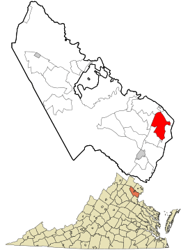 Location in Prince William County and the state of Virginia. | |
| Coordinates: 38°38′17″N 77°15′32″W / 38.63806°N 77.25889°WCoordinates: 38°38′17″N 77°15′32″W / 38.63806°N 77.25889°W | |
| Country | United States |
| State | Virginia |
| County | Prince William |
| Population (2013) | |
| • Total | 37,218 |
| • Density | 5,015/sq mi (1,936/km2) |
| Time zone | UTC−5 (Eastern (EST)) |
| • Summer (DST) | UTC−4 (EDT) |
| ZIP codes | 22191 |
| FIPS code | 51-49792 |
| GNIS feature ID | 2629767 |
Marumsco is a census-designated place in Prince William County, Virginia. The population was estimated at 37,218 in 2013.[1] The CDP consists of the major portion of what was Woodbridge CDP up to 2000, including the subdivisions of Marumsco Village, Marumsco Hills, Marumsco Acres and Marumsco Woods. The name comes from an Algonquin word meaning "island rock." [2]
Background
The U.S. census bureau designated Marumsco from Woodbridge, Virginia in 2011. Almost 90 percent of residents who lived in Woodbridge in 2000, along with 80 percent of the land, became part of Marumsco.[2] With a population of about 37,000 residents and a density of about 5,000 residents per square mile, Marumsco covers a large portion of route 1 in Prince William County. This in turn creates a high traffic of people consisting of both residents and everyday commuters going north typically to Fairfax County as well as the D.C. metropolitan area. Marumsco is measured between the streets of Occoquan road and Optiz Blvd.
References
- ↑ Virginia Trend Report 2: State and Complete Places (Sub-state 2010 Census Data). Missouri Census Data Center. Accessed 2011-06-08.
- 1 2 Morello, Carol (11 February 2011). "As Woodbridge becomes Marumsco, more than the name changes". The Washington Post. Retrieved 13 December 2017.

Municipalities and communities of Prince William County, Virginia, United States | ||
|---|---|---|
| Towns | 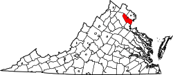 | |
| CDPs | ||
| Unincorporated communities | ||
| Footnotes | ‡This populated place also has portions in an adjacent county or counties | |