Joplin, Virginia
| Joplin, Virginia | |
|---|---|
| Ghost town | |
 Joplin, Virginia Location within the state of Virginia  Joplin, Virginia Joplin, Virginia (Virginia)  Joplin, Virginia Joplin, Virginia (the US) | |
| Coordinates: 38°33′39″N 77°23′6″W / 38.56083°N 77.38500°WCoordinates: 38°33′39″N 77°23′6″W / 38.56083°N 77.38500°W | |
| Country |
|
| State |
|
| County |
|
| Time zone | UTC-5 (Eastern (EST)) |
| • Summer (DST) | UTC-4 (EDT) |
Joplin is an uninhabited unincorporated community in Prince William County, Virginia. The town was located on land taken to form Chopawamsic Recreational Demonstration Area[1] and is now part of Prince William Forest Park, a National Park Service property located adjacent to Marine Corps Base Quantico. The remains of the town, now just a collection of homes, lies on a stretch of Va. 619, Joplin Road, about 3 miles west of Dumfries.
References
See also
Municipalities and communities of Prince William County, Virginia, United States | ||
|---|---|---|
| Towns | 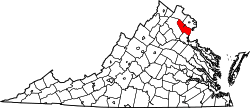 | |
| CDPs | ||
| Unincorporated communities | ||
| Footnotes | ‡This populated place also has portions in an adjacent county or counties | |
This article is issued from
Wikipedia.
The text is licensed under Creative Commons - Attribution - Sharealike.
Additional terms may apply for the media files.