Scottsburg, Virginia
| Scottsburg, Virginia | |
|---|---|
| Town | |
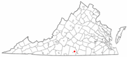 Location of Scottsburg, Virginia | |
| Coordinates: 36°45′36″N 78°47′26″W / 36.76000°N 78.79056°WCoordinates: 36°45′36″N 78°47′26″W / 36.76000°N 78.79056°W | |
| Country | United States |
| State | Virginia |
| County | Halifax |
| Area | |
| • Total | 0.7 sq mi (1.8 km2) |
| • Land | 0.7 sq mi (1.8 km2) |
| • Water | 0.0 sq mi (0.0 km2) |
| Elevation | 374 ft (114 m) |
| Population (2010) | |
| • Total | 119 |
| • Density | 172/sq mi (66.4/km2) |
| Time zone | UTC-5 (Eastern (EST)) |
| • Summer (DST) | UTC-4 (EDT) |
| ZIP code | 24589 |
| Area code(s) | 434 |
| FIPS code | 51-70752[1] |
| GNIS feature ID | 1474116[2] |
Scottsburg is a town in Halifax County, Virginia, United States. The population was 119 at the 2010 census,[3] down from 145 at the 2000 census.
Geography
Scottsburg is located in eastern Halifax County at 36°45′36″N 78°47′26″W / 36.76000°N 78.79056°W (36.759890, -78.790515).[4] Virginia State Route 344 passes through the center of town, leading northwest 2 miles (3 km) to U.S. Route 360 and southeast 8 miles (13 km) to its end at Staunton River State Park.
According to the United States Census Bureau, Scottsburg has a total area of 0.69 square miles (1.8 km2), of which 2.3 acres (9,371 m2), or 0.52%, are water.[3] Gibson Creek, a tributary of the Banister River, flows north to south through the center of town.
Demographics
| Historical population | |||
|---|---|---|---|
| Census | Pop. | %± | |
| 1880 | 87 | — | |
| 1890 | 297 | 241.4% | |
| 1930 | 225 | — | |
| 1940 | 239 | 6.2% | |
| 1950 | 222 | −7.1% | |
| 1960 | 188 | −15.3% | |
| 1970 | 157 | −16.5% | |
| 1980 | 335 | 113.4% | |
| 1990 | 152 | −54.6% | |
| 2000 | 145 | −4.6% | |
| 2010 | 119 | −17.9% | |
| Est. 2016 | 131 | [5] | 10.1% |
| U.S. Decennial Census[6] | |||
As of the census[1] of 2000, there were 145 people, 56 households, and 39 families residing in the town. The population density was 196.0 people per square mile (75.7/km²). There were 64 housing units at an average density of 86.5 per square mile (33.4/km²). The racial makeup of the town was 80.69% White, 16.55% African American, 2.76% from other races. Hispanic or Latino of any race were 6.21% of the population.
There were 56 households out of which 35.7% had children under the age of 18 living with them, 51.8% were married couples living together, 17.9% had a female householder with no husband present, and 28.6% were non-families. 26.8% of all households were made up of individuals and 10.7% had someone living alone who was 65 years of age or older. The average household size was 2.59 and the average family size was 3.13.
In the town, the population was spread out with 30.3% under the age of 18, 6.2% from 18 to 24, 29.7% from 25 to 44, 21.4% from 45 to 64, and 12.4% who were 65 years of age or older. The median age was 34 years. For every 100 females there were 88.3 males. For every 100 females age 18 and over, there were 87.0 males.
The median income for a household in the town was $28,750, and the median income for a family was $25,938. Males had a median income of $28,750 versus $24,583 for females. The per capita income for the town was $15,289. There were 13.3% of families and 10.7% of the population living below the poverty line, including 8.9% of under eighteens and 19.0% of those over 64.
References
- 1 2 "American FactFinder". United States Census Bureau. Retrieved 2008-01-31.
- ↑ "US Board on Geographic Names". United States Geological Survey. 2007-10-25. Retrieved 2008-01-31.
- 1 2 "Geographic Identifiers: 2010 Census Summary File 1 (G001):". American Factfinder. U.S. Census Bureau. Retrieved March 20, 2018.
- ↑ "US Gazetteer files: 2010, 2000, and 1990". United States Census Bureau. 2011-02-12. Retrieved 2011-04-23.
- ↑ "Population and Housing Unit Estimates". Retrieved June 9, 2017.
- ↑ "Census of Population and Housing". Census.gov. Retrieved June 4, 2015.
Municipalities and communities of Halifax County, Virginia, United States | ||
|---|---|---|
| Towns | 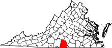 | |
| CDPs | ||
| Unincorporated communities | ||
| Footnotes | ‡This populated place also has portions in an adjacent county or counties | |