Fincastle, Virginia
| Fincastle, Virginia | |
|---|---|
| Town | |
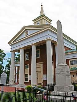 The historic Botetourt County Courthouse in Fincastle, Virginia. | |
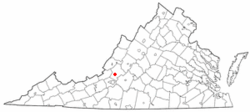 Location of Fincastle, Virginia | |
| Coordinates: 37°29′58″N 79°52′36″W / 37.49944°N 79.87667°WCoordinates: 37°29′58″N 79°52′36″W / 37.49944°N 79.87667°W | |
| Country | United States |
| State | Virginia |
| County | Botetourt |
| Area | |
| • Total | 0.2 sq mi (0.6 km2) |
| • Land | 0.2 sq mi (0.6 km2) |
| • Water | 0.0 sq mi (0.0 km2) |
| Elevation | 1,240 ft (378 m) |
| Population (2000) | |
| • Total | 359 |
| • Density | 1,480.8/sq mi (571.8/km2) |
| Time zone | UTC-5 (Eastern (EST)) |
| • Summer (DST) | UTC-4 (EDT) |
| ZIP code | 24090 |
| Area code(s) | 540 |
| FIPS code | 51-27824[1] |
| GNIS feature ID | 1498478[2] |
Fincastle is a town in Botetourt County, Virginia, United States. The population was 353 at the 2010 census. It is the county seat of Botetourt County.[3]
Fincastle is part of the Roanoke Metropolitan Statistical Area.
History
The town of Fincastle was originally settled by Scotch-Irish and German immigrants from Pennsylvania who arrived in the region in the mid-18th century. John Miller erected a sawmill which became the nucleus of the early village of Fincastle. In 1770, Botetourt County was separated from Augusta County, and Miller's home was selected as the meeting place for the court. Two years later, Israel Christian donated 45 acres (18 ha) of land and laid out the streets and lots for the new town of Fincastle. The town's name was selected to honor George, Lord Fincastle, the eldest son of Virginia's Lieutenant Governor, Lord Dunmore.[4]
In 1773, the first log courthouse was built on the designated court square at the center of Fincastle. Around the same time, a brick church was constructed on land donated by Israel Christian to serve as the established (Anglican) house of worship for the town. The church closed after the disestablishment of the Anglican Church in Virginia during the Revolutionary War and was later occupied by Presbyterians who rebuilt the structure to its present Greek Revival style.[5] By the early-19th century, the village had grown into an important regional center of commerce, especially for the wool industry, aided by the construction of taverns, hotels, and shops. A second courthouse was erected in 1818 and replaced by a third, a larger brick structure of Greek Revival style in 1850. This courthouse continues to serve Botetourt County today, having been rebuilt after a disastrous fire in 1970.
The Bowyer-Holladay House, Breckinridge Mill, Fincastle Historic District, Greenfield, Hawthorne Hall, Prospect Hill, Santillane, Wheatland Manor, and Wiloma are listed on the National Register of Historic Places.[6]
Geography
Fincastle is located at 37°29′58″N 79°52′36″W / 37.499421°N 79.876674°W (37.499421, -79.876674).[7]
According to the United States Census Bureau, the town has a total area of 0.2 square mile (0.6 km2), all land.
Demographics
| Historical population | |||
|---|---|---|---|
| Census | Pop. | %± | |
| 1860 | 896 | — | |
| 1880 | 675 | — | |
| 1900 | 652 | — | |
| 1910 | 479 | −26.5% | |
| 1920 | 457 | −4.6% | |
| 1930 | 517 | 13.1% | |
| 1940 | 442 | −14.5% | |
| 1950 | 405 | −8.4% | |
| 1960 | 403 | −0.5% | |
| 1970 | 397 | −1.5% | |
| 1980 | 282 | −29.0% | |
| 1990 | 236 | −16.3% | |
| 2000 | 359 | 52.1% | |
| 2010 | 353 | −1.7% | |
| Est. 2016 | 339 | [8] | −4.0% |
| U.S. Decennial Census[9] | |||
As of the census[1] of 2000, there were 359 people, 129 households, and 83 families residing in the town. The population density was 1,480.8 people per square mile (577.5/km2). There were 142 housing units at an average density of 585.7 per square mile (228.4/km2). The racial makeup of the town was 89.69% White, 7.52% African American, 0.28% Native American, 0.28% Asian, 1.67% from other races, and 0.56% from two or more races. Hispanic or Latino of any race were 1.95% of the population.
There were 129 households out of which 27.1% had children under the age of 18 living with them, 51.9% were married couples living together, 10.1% had a female householder with no husband present, and 34.9% were non-families. 32.6% of all households were made up of individuals and 13.2% had someone living alone who was 65 years of age or older. The average household size was 2.39 and the average family size was 3.04.
In the town, the population was spread out with 19.8% under the age of 18, 11.1% from 18 to 24, 32.3% from 25 to 44, 24.2% from 45 to 64, and 12.5% who were 65 years of age or older. The median age was 39 years. For every 100 females there were 117.6 males. For every 100 females age 18 and over, there were 126.8 males.
The median income for a household in the town was $33,438, and the median income for a family was $54,688. Males had a median income of $32,500 versus $21,563 for females. The per capita income for the town was $19,954. None of the families and 2.3% of the population were living below the poverty line, including no under eighteens and 10.2% of those over 64.
Notable people
- Jacob Ammen, (1807–1894), born in Fincastle, Union Army general[10]
- Joseph R. Anderson, (1813–1892), born in Fincastle, Confederate Army general and iron manufacturer[10]
- John Strother Griffin (1816–1898), physician and land developer, Los Angeles, California
- William Radford (1808–1890), Union Navy officer and later Admiral
References
- 1 2 "American FactFinder". United States Census Bureau. Archived from the original on 2013-09-11. Retrieved 2008-01-31.
- ↑ "US Board on Geographic Names". United States Geological Survey. 2007-10-25. Retrieved 2008-01-31.
- ↑ "Find a County". National Association of Counties. Archived from the original on 2011-05-31. Retrieved 2011-06-07.
- ↑ Botetourt Heritage Book Committee (2000). Botetourt County, Virginia Heritage Book 1770-2000 (Millenium ed.). Summersville, WV: Walsworth Publishing Company. pp. 21–22.
- ↑ Fincastle Presbyterian Church. "History of Fincastle Presbyterian Church".
- ↑ National Park Service (2010-07-09). "National Register Information System". National Register of Historic Places. National Park Service.
- ↑ "US Gazetteer files: 2010, 2000, and 1990". United States Census Bureau. 2011-02-12. Retrieved 2011-04-23.
- ↑ "Population and Housing Unit Estimates". Retrieved June 9, 2017.
- ↑ "Census of Population and Housing". Census.gov. Archived from the original on May 12, 2015. Retrieved June 4, 2015.
- 1 2 Who Was Who in America, Historical Volume, 1607-1896. Marquis Who's Who. 1967.
Municipalities and communities of Botetourt County, Virginia, United States | ||
|---|---|---|
| Towns |  | |
| CDPs | ||
| Unincorporated communities |
| |
| Footnotes | ‡This populated place also has portions in an adjacent county or counties | |