Pohled (Havlíčkův Brod District)
| Pohled | |
|---|---|
| Municipality | |
 | |
 Pohled | |
| Coordinates: 49°36′22″N 15°38′53″E / 49.60611°N 15.64806°ECoordinates: 49°36′22″N 15°38′53″E / 49.60611°N 15.64806°E | |
| Country |
|
| Region | Vysočina |
| District | Havlíčkův Brod |
| Area | |
| • Total | 10.67 km2 (4.12 sq mi) |
| Elevation | 437 m (1,434 ft) |
| Population (2006) | |
| • Total | 781 |
| • Density | 73/km2 (190/sq mi) |
| Postal code | 582 21 to 582 22 |
| Website | http://www.obecpohled.cz |
Pohled is a village and municipality (obec) in Havlíčkův Brod District in the Vysočina Region of the Czech Republic.
The municipality covers an area of 10.67 square kilometres (4.12 sq mi), and had a population of 781 as at 3 July 2006.
Pohled lies approximately 6 kilometres (4 mi) east of Havlíčkův Brod, 24 km (15 mi) north of Jihlava, and 103 km (64 mi) south-east of Prague.
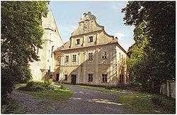
Gallery
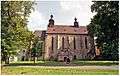 Monasterial church of St. Andrew
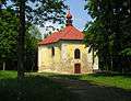 Pilgrimage church of Saint Anne
References
| Wikimedia Commons has media related to Pohled. |
This article is issued from
Wikipedia.
The text is licensed under Creative Commons - Attribution - Sharealike.
Additional terms may apply for the media files.