Štoky
| Štoky | |||
|---|---|---|---|
| Městys | |||
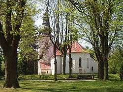 Church of Saint James the Elder | |||
| |||
 Štoky | |||
| Coordinates: 49°29′53″N 15°35′10″E / 49.49806°N 15.58611°ECoordinates: 49°29′53″N 15°35′10″E / 49.49806°N 15.58611°E | |||
| Country |
| ||
| Region | Vysočina | ||
| District | Havlíčkův Brod | ||
| Area | |||
| • Total | 39.67 km2 (15.32 sq mi) | ||
| Elevation | 518 m (1,699 ft) | ||
| Population (2006) | |||
| • Total | 1,617 | ||
| • Density | 41/km2 (110/sq mi) | ||
| Postal code | 582 53 | ||
| Website | http://www.stoky.cz | ||
Štoky (German: Stecken) is a market town (městys) in Havlíčkův Brod District in the Vysočina Region of the Czech Republic.
The town covers an area of 39.67 square kilometres (15.32 sq mi), and has a population of 1,617 (as at 28 August 2006).
Štoky lies approximately 12 kilometres (7 mi) south of Havlíčkův Brod, 12 km (7 mi) north of Jihlava, and 107 km (66 mi) south-east of Prague.
References
| Wikimedia Commons has media related to Štoky. |
This article is issued from
Wikipedia.
The text is licensed under Creative Commons - Attribution - Sharealike.
Additional terms may apply for the media files.