Česká Bělá
| Česká Bělá | |||
|---|---|---|---|
| Městys | |||
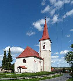 Saint Bartholomew Church | |||
| |||
 Česká Bělá | |||
| Coordinates: 49°38′41″N 15°41′28″E / 49.64472°N 15.69111°ECoordinates: 49°38′41″N 15°41′28″E / 49.64472°N 15.69111°E | |||
| Country |
| ||
| Region | Vysočina | ||
| District | Havlíčkův Brod | ||
| Area | |||
| • Total | 15.99 km2 (6.17 sq mi) | ||
| Elevation | 510 m (1,670 ft) | ||
| Population (1.1.2014) | |||
| • Total | 1,021 | ||
| • Density | 64/km2 (170/sq mi) | ||
| Postal code | 582 61 to 583 01 | ||
Česká Bělá (Czech pronunciation: [ˈtʃɛskaː ˈbjɛlaː]) is a market town (městys) in Havlíčkův Brod District in the Vysočina Region of the Czech Republic.
The town covers an area of 15.99 square kilometres (6.17 sq mi), and has a population of 1,011 (as at 28 August 2006).
Česká Bělá lies approximately 10 kilometres (6 mi) north-east of Havlíčkův Brod, 29 km (18 mi) north of Jihlava, and 104 km (65 mi) south-east of Prague.
References
| Wikimedia Commons has media related to Česká Bělá. |
This article is issued from
Wikipedia.
The text is licensed under Creative Commons - Attribution - Sharealike.
Additional terms may apply for the media files.