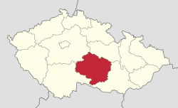
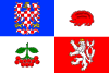
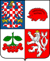
Vysočina Region
| Vysočina Kraj Vysočina | |||
|---|---|---|---|
| Region | |||
 | |||
| |||
 | |||
| Coordinates: 49°35′22″N 15°39′20″E / 49.58944°N 15.65556°ECoordinates: 49°35′22″N 15°39′20″E / 49.58944°N 15.65556°E | |||
| Country | Czech Republic | ||
| Capital | Jihlava | ||
| Districts | Jihlava District, Pelhřimov District, Třebíč District, Žďár nad Sázavou District, Havlíčkův Brod District | ||
| Government | |||
| • Governor | Jiří Běhounek | ||
| Area | |||
| • Total | 6,795.56 km2 (2,623.78 sq mi) | ||
| Highest elevation | 837 m (2,746 ft) | ||
| Population (01/2012) | |||
| • Total | 511,937 | ||
| • Density | 75/km2 (200/sq mi) | ||
| ISO 3166 code | CZ-VY | ||
| Vehicle registration | J | ||
| Website | http://www.kr-vysocina.cz/ | ||
The Vysočina Region (IPA: [ˈvɪsotʃɪna]; Czech: Kraj Vysočina "Highlands Region", German: Region Hochland), is an administrative unit (Czech: kraj) of the Czech Republic, located partly in the south-eastern part of the historical region of Bohemia and partly in the south-west of the historical region of Moravia. Its capital is Jihlava.
The region is the location of two mountain ranges, Žďárské vrchy and Jihlavské vrchy, both part of the Bohemian-Moravian Highlands. The Vysočina Region is home to three UNESCO World Heritage Sites, the most in any region in the Czech Republic.[1] The region is one of just three in the country (the others being Prague and the Central Bohemian Region) which does not have a border with a foreign country.[2]
Administrative divisions
The Vysočina Region is divided into 5 districts:[3]
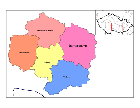 | |||||||||||||
Districts of Vysočina Region
| |||||||||||||
On a lower level, the region has 704 municipalities, second-most in the country behind the Central Bohemian Region.[4]
Cities and towns
- Jihlava
- Brtnice
- Bystřice nad Pernštejnem
- Chotěboř
- Golčův Jeníkov
- Habry
- Havlíčkův Brod
- Horní Cerekev
- Humpolec
- Jaroměřice nad Rokytnou
- Ledeč nad Sázavou
- Moravské Budějovice
- Náměšť nad Oslavou
- Nové Město na Moravě
- Pacov
- Pelhřimov
- Polná
- Přibyslav
- Světlá nad Sázavou
- Svratka
- Telč
- Třebíč
- Třešť
- Velká Bíteš
- Velké Meziříčí
- Žďár nad Sázavou
- Ždírec nad Doubravou
Demography
As of 1 January 2012 the population of the Vysočina Region was 511,937[3] with 253,985 males and 257,952 females, accounting for 49.6% and 50.4% of the population respectively.[3]
Culture
.jpg)
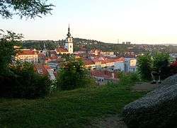
With three UNESCO World Heritage Sites, the region is home to more of these than any other region of the Czech Republic.[1] These are the historical centre of Telč, the Pilgrimage Church of Saint John of Nepomuk in Žďár nad Sázavou and the Jewish Quarter and St Procopius' Basilica in Třebíč.[1]
Transport
The Vysočina Region is intersected by the D1 motorway, which passes through Jihlava on the way between Prague and Brno. A total of 93 km (58 mi) of motorway is present in the region.[5] The length of operated railway lines in the region is 622 km (386 mi).[5] In 2014 a plan was announced by which a high-speed train, capable of reaching speeds of 350 km/h (220 mph) would run through the region, involving a total of four stops within the territory.[6] Construction is projected to begin in 2025.[6]
Education
In the Vysočina Region there are two organisations providing further education, namely College of Polytechnics Jihlava and Westmoravian College Třebíč. The College of Polytechnics Jihlava is the only public college in the region,[7] whereas Westmoravian College Třebíč is a private institution, established in 2003.
References
- 1 2 3 "Vysočina: kraj s nejvyšším počtem památek UNESCO" [Vysočina: region with the highest number of UNESCO monuments]. Právo (in Czech). Novinky.cz. 25 January 2007. Retrieved 22 April 2014.
- ↑ "Charakteristika kraje Vysočina". Metodická podpora regionálního rozvoje (in Czech). Retrieved 22 April 2014.
- 1 2 3 "Počet obyvatel v oblastech, krajích a okresech České republiky k 1. 1. 2012" [Population of territorial units of the Czech republic, 1 January 2012] (XLS). Czech Statistical Office. Retrieved 22 April 2014.
- ↑ "Statistical Yearbook of the Kraj Vysočina Region 2011" (PDF). Czech Statistical Office. Retrieved 22 April 2014.
- 1 2 "Doprava" [Transport] (XLS). Czech Statistical Office. Retrieved 22 April 2014.
- 1 2 Paclík, Jaroslav (15 January 2014). "Vysokorychlostní vlak pojede až 350 km/h, na Vysočině zastaví čtyřikrát" [High-speed train will go up to 350km/h, stop four times in Vysočina] (in Czech). Retrieved 22 April 2014.
- ↑ "Welcome to the College of Polytechnics Jihlava". 3 August 2012. Retrieved 22 April 2014.
External links
- Official website (in Czech) (in English) (in German)