Kyjov (Havlíčkův Brod District)
| Kyjov | |
|---|---|
| Municipality | |
 | |
 Kyjov | |
| Coordinates: 49°37′48″N 15°37′38″E / 49.63000°N 15.62722°ECoordinates: 49°37′48″N 15°37′38″E / 49.63000°N 15.62722°E | |
| Country |
|
| Region | Vysočina |
| District | Havlíčkův Brod |
| Area | |
| • Total | 3.95 km2 (1.53 sq mi) |
| Elevation | 468 m (1,535 ft) |
| Population (2006) | |
| • Total | 130 |
| • Density | 33/km2 (85/sq mi) |
| Postal code | 580 01 |
Kyjov is a village and municipality (obec) in Havlíčkův Brod District in the Vysočina Region of the Czech Republic.
The municipality covers an area of 3.95 square kilometres (1.53 sq mi), and has a population of 130 (as at 28 August 2006).
Kyjov lies approximately 5 kilometres (3 mi) north-east of Havlíčkův Brod, 27 km (17 mi) north of Jihlava, and 101 km (63 mi) south-east of Prague.
Gallery
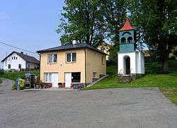
 Common in Kyjov
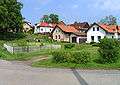
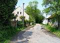 Local part Dvorce
References
| Wikimedia Commons has media related to Kyjov (Havlíčkův Brod District). |
This article is issued from
Wikipedia.
The text is licensed under Creative Commons - Attribution - Sharealike.
Additional terms may apply for the media files.