Havlíčkova Borová
| Havlíčkova Borová | |||
|---|---|---|---|
| Městys | |||
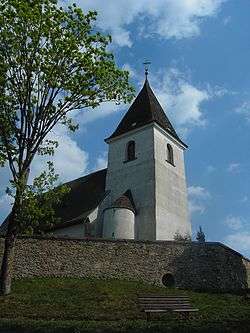 Saint Vitus Church | |||
| |||
 Havlíčkova Borová | |||
| Coordinates: 49°38′18″N 15°47′17″E / 49.63833°N 15.78806°ECoordinates: 49°38′18″N 15°47′17″E / 49.63833°N 15.78806°E | |||
| Country |
| ||
| Region | Vysočina | ||
| District | Havlíčkův Brod | ||
| Area | |||
| • Total | 22.79 km2 (8.80 sq mi) | ||
| Elevation | 586 m (1,923 ft) | ||
| Population (1.1.2014) | |||
| • Total | 985 | ||
| • Density | 43/km2 (110/sq mi) | ||
| Postal code | 582 23 | ||
Havlíčkova Borová formerly just Borová (German: Borau) is a market town (městys) in Havlíčkův Brod District in the Vysočina Region of the Czech Republic.
The town covers an area of 22.79 square kilometres (8.80 sq mi), and has a population of 949 (as at 3 July 2006).
Havlíčkova Borová lies approximately 16 kilometres (10 mi) east of Havlíčkův Brod, 31 km (19 mi) north-east of Jihlava, and 111 km (69 mi) south-east of Prague.
References
| Wikimedia Commons has media related to Havlíčkova Borová. |
This article is issued from
Wikipedia.
The text is licensed under Creative Commons - Attribution - Sharealike.
Additional terms may apply for the media files.