Oudoleň
| Oudoleň | |||
|---|---|---|---|
| Municipality | |||
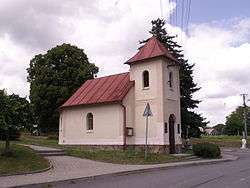 Chapel of the Virgin Mary | |||
| |||
 Oudoleň | |||
| Coordinates: 49°39′42″N 15°45′38″E / 49.66167°N 15.76056°ECoordinates: 49°39′42″N 15°45′38″E / 49.66167°N 15.76056°E | |||
| Country |
| ||
| Region | Vysočina | ||
| District | Havlíčkův Brod | ||
| Area | |||
| • Total | 6.47 km2 (2.50 sq mi) | ||
| Elevation | 550 m (1,800 ft) | ||
| Population (2006) | |||
| • Total | 341 | ||
| • Density | 53/km2 (140/sq mi) | ||
| Postal code | 582 24 | ||
| Website | http://www.oudolen.cz | ||
Oudoleň (German: Audolen) is a village and municipality (obec) in Havlíčkův Brod District in the Vysočina Region of the Czech Republic.
The municipality covers an area of 6.47 square kilometres (2.50 sq mi), and has a population of 341 (as at 3 July 2006).
Oudoleň lies approximately 15 kilometres (9 mi) north-east of Havlíčkův Brod, 32 km (20 mi) north-east of Jihlava, and 108 km (67 mi) south-east of Prague.
References
| Wikimedia Commons has media related to Oudoleň. |
This article is issued from
Wikipedia.
The text is licensed under Creative Commons - Attribution - Sharealike.
Additional terms may apply for the media files.