Kojetín (Havlíčkův Brod District)
| Kojetín | |||
|---|---|---|---|
| Municipality | |||
 | |||
| |||
 Kojetín | |||
| Coordinates: 49°39′22″N 15°38′51″E / 49.65611°N 15.64750°ECoordinates: 49°39′22″N 15°38′51″E / 49.65611°N 15.64750°E | |||
| Country |
| ||
| Region | Vysočina | ||
| District | Havlíčkův Brod | ||
| Area | |||
| • Total | 7.99 km2 (3.08 sq mi) | ||
| Elevation | 523 m (1,716 ft) | ||
| Population (1.1.201) | |||
| • Total | 156 | ||
| • Density | 20/km2 (51/sq mi) | ||
| Postal code | 580 01 | ||
_vlajka.jpg)
_znak.jpg)
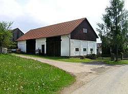
Kojetín is a village and municipality (obec) in Havlíčkův Brod District in the Vysočina Region of the Czech Republic.
The municipality covers an area of 7.99 square kilometres (3.08 sq mi), and has a population of 165 (as at 3 July 2006).
Kojetín lies approximately 8 kilometres (5 mi) north-east of Havlíčkův Brod, 30 km (19 mi) north of Jihlava, and 101 km (63 mi) south-east of Prague.
Gallery
 Lower pond
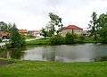
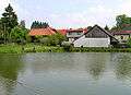 Upper pond
References
| Wikimedia Commons has media related to Kojetín (Havlíčkův Brod District). |
This article is issued from
Wikipedia.
The text is licensed under Creative Commons - Attribution - Sharealike.
Additional terms may apply for the media files.