Peki'in
Peki'in
| |
|---|---|
| Hebrew transcription(s) | |
| • ISO 259 | Pqiˁin |
| • Also spelled | Peqi'in (official) |
 | |
 Peki'in | |
| Coordinates: 32°58′27″N 35°19′53″E / 32.97417°N 35.33139°ECoordinates: 32°58′27″N 35°19′53″E / 32.97417°N 35.33139°E | |
| Grid position | 181/264 PAL |
| District | Northern |
| Founded | 5000 BCE (Earliest settlement) |
| Government | |
| • Type | Local council |
| Area | |
| • Total | 3,565 dunams (3.565 km2 or 1.376 sq mi) |
| Population (2017)[1] | |
| • Total | 5,767 |
| • Density | 1,600/km2 (4,200/sq mi) |
| Name meaning | The little valley (between mountains)[2] |
Peki'in (alternatively Peqi'in) (Hebrew: פְּקִיעִין) or Buqei'a (Arabic: البقيعة), is a Druze town with local council status in Israel's Northern District. It is located eight kilometres east of Ma'alot-Tarshiha in the Upper Galilee. In 2017 it had a population of 5,767.[1]
According to tradition, the Jewish community of Peki'in has maintained a presence there since the Second Temple period.[3][4] The only interruption in their presence was during the 1936–1939 Arab riots. Most Jews in Peki'in did not return to the village after the violence, which they called the Hadera diaspora. It is believed that the Zinatis are the only family who returned, and this family has dwindled to one member.
History
Antiquity
Objects such as potsherds and Ossuaries of the Chalcolithic period were found in the village, and a burial site close by, making a 100 dunams (25 acres) settlement a possibility.[5] A 2018 study[6] conducted by scholars from Tel-Aviv University, the Israel Antiquities Authority and Harvard University had discovered that 22 out of the 600 people who were buried in Peki'in cave from the Chalcolithic Period were of both local Levantine and Persian and Zagros[7] area ancestries, or as phrased in the paper itself: "Ancient DNA from Chalcolithic Israel reveals the role of population mixture in cultural transformation,” the scientists concluded that the homogeneous community found in the cave could source ~57% of its ancestry from groups related to those of the local Levant Neolithic, ~26% from groups related to those of the Anatolian Neolithic, and ~17% from groups related to those of the Iran Chalcolithic.".[8] The scholars noted that the Zagros genetic material held "Certain characteristics, such as genetic mutations contributing to blue eye color, were not seen in the DNA test results of earlier Levantine human remains...The blue-eyed, fair-skinned community didn't continue, but at least now researchers have an idea why. "These findings suggest that the rise and fall of the Chalcolithic culture are probably due to demographic changes in the region".[9]
The village Baca in Josephus' The Jewish War[10] is thought to be Peki'in.[11][12][13] According to Josephus it marked the border between the kingdom of Herod Agrippa II, and Tyre.
A bundle of Jewish traditions is associated with a certain Peki'in often, appearing in writing under the names Baka, Paka and Peki'in, which gave rise to the theory that a Jewish community lived there continuously from the Second Temple period. According to the Talmud, Rabbi Joshua ben Hananiah run a Beth Midrash, Rabbi Shimon bar Yochai and his son Rabbi Elazar ben Shimon, hid in a cave from the Romans for 13 years,[14][15] and Shimon bar Yochai went on to teach at the city. However, there is evidence that the identification of Rabbinic Peki'in with Peki'in-Buqei'a is of Ottoman time,[16] and other sites in the vicinity of Rehovot have also been suggested. The first writing where the name Peki'in undoubtedly refers to this village is from a 1765 Hebrew travel book.[17]
Crusader era
In the Crusader era, Peki'in was known under the name of Bokehel.[18] Together with several other villages in the area, it was part of the lordship of St. George, one of the largest in the Acre area. In the 12th century it was held by Henry de Milly, after his death it was inherited by his three daughters.[19][20]
Henry de Milly's third and youngest daughter, Agnes of Milly, married Joscelin III. In 1220 their daughter Beatrix de Courtenay and her husband Otto von Botenlauben, Count of Henneberg, sold their land, including "one third of the fief of St. George", and "one third of the village of Bokehel", to the Teutonic Knights.[21] During this era the village was connected by a road to Castellum Regis.[22]
Ottoman era

Incorporated into the Ottoman Empire in 1517 with the rest of Palestine, Peki'in appeared in the 1596 tax registers as being in the Nahiya of Akka of the Liwa of Safad. It had a population of 77 households and 7 bachelors who were all Muslims, in addition to 79 Jewish households. The villagers paid taxes on occasional revenues, goats and/or beehives, a press for olives or grapes, and jizya.[23] A tax on silk spinning (dulab harir), which was levied in 1555 on six villages surrounding Mount Meron, rated highest in Peki'in.[24] A silk industry is also attested by an account from 1602,[25] and by several old mulberry trees in the village.
Jewish population was recorded at 33 households in 1525, and experienced a rise, drop, stabilization and another rise before 1596.[26] It is said some Kohanitic families emigrated from Kafr 'Inan, possibly in the late 16th century.[27] The Almani family probably came from the village Alma.[28]
In 1875, French explorer Victor Guérin visited the village and described it as: "The population at present number 600—Druzes, United Greeks, Schismatic Greeks, and a few Jewish families, who pretend to descend from the ancient inhabitants of the country. Every year in the summer several hundreds of Jews come here from Tiberias to pass the hot season. Most of these Jews came originally from Europe, and are happy in finding here the last indigenous scions of the ancient national stock. ... At Bukeiah, thanks to the two springs which issue from the hill-side, they cultivate on the slopes and almost to the bottom of the valley delicious gardens, watered by numerous streams. Here grow, on different terraces, kept up by great walls, probably ancient, fruit-trees of all kinds, such as citrons, oranges, pomegranates, figs, quinces, and mulberries. The vine flourishes marvelously, as is shown by the enormous trunks. The United Greeks have a little church, which I found shut; the Schismatic Greeks also have one which has replaced a much more ancient Christian sanctuary. Only a few cut stones and the trunk of a column remain of it.The Jews worship in a synagogue of modern date."[29]
In 1881, the Palestine Exploration Fund's Survey of Western Palestine described it as "A good village, built of stone, containing a chapel and a synagogue. There are about 100 Moslems, 100 Christians, 100 Druzes, and 100 Jews. It is situated on the slope of tine hill, with gardens, figs, olives, pomegranates, and arable land.
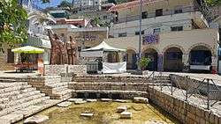
There is a good spring in the village, and two springs near. This is the only place where Jews cultivate the ground. They say it has descended to them from their fathers from time immemorial."[30]
A population list from about 1887 showed el Bukei’a to have about 950 inhabitants; Druse, Jews and Christians.[31]
British Mandate era
In a census conducted in 1922 by the British Mandate authorities, Al Buqai'a had a population of 652 residents; 70 Muslims, 63 Jews, 215 Christians and 304 Druse.[32] Of the Christians, 167 were Orthodox and 48 were Greek Catholic (Melchite).[33] In the 1931 census, El Buqei'a had a total population of 799; 71 Muslims, 52 Jews, 264 Christians and 412 Druse, in a total of 190 houses.[34]
In 1936, Arab riots forced the Jews of Peki'in to leave their homes for safer parts of the country; only a few of them later returned.[3]
In the 1945 statistics, the population was 990; 100 Muslims, 370 Christians, and 520 "others", that is Druse,[35] owning 10,276 dunams, while Jews owned 189 dunams, and 3,731 was publicly owned, according to an official land and population survey.[36] Of this, 1,598 were allocated for plantations and irrigable land, 3,424 for cereals,[37] while 40 dunams were classified as built-up areas.[38]
State of Israel
In July 2006, Peki'in was hit by Katyusha rockets launched by Hezbollah, causing significant damage to homes and orchards.[39]
In October 2007, riots broke out after the installation of a cellular antenna due to concerns that such antennas have been linked to an increase in cancer. Riot police fired bullets and gas grenades, which further angered the residents, who burned down the house of a Jewish family living in the village.[40] In December 2007, the last Jewish family left the town after their car was torched.[41] Only Margalit Zinati, a descendant of a Mustarabim family, has remained there to keep alive the memory of the town's vanishing Jewish heritage.[3]
In 2011, the Israeli government approved an aid program of NIS 680 million ($184M) for housing, education and tourism upgrades in Peki'in and other Druze communities in northern Israel.[42]
Education and culture
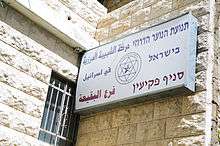
The Druze Youth Movement in Israel, a movement with 19 branches around the country and a membership of 12,000, has its headquarters in Peki'in. The founder of the movement is Hamad Amar, an Israeli Druze member of the Knesset from Shfaram, who established it to pass on Druze heritage to the younger generation while developing a sense of national Israeli pride.[43]
Tourism
According to Galib Kheir, head of the town's tourism department, about 60,000 tourists visit Peki'in each year. The tourist trade supports local restaurants and specialty shops. The town also has a hotel and youth hostel.
See also
References
- 1 2 "List of localities, in Alphabetical order" (PDF). Israel Central Bureau of Statistics. Retrieved August 26, 2018.
- ↑ Palmer, 1881, p. 70
- 1 2 3 Researchers race to document vanishing Jewish heritage of Galilee Druze village, Eli Ashkenaz, 25 July 2012, Haaretz, "Zinati, who was born in 1931, is the last link in the chain of a Jewish community that apparently maintained a continuous presence in Peki'in since the time of the Second Temple, when three families from the ranks of the kohenim, the priestly caste that served in the Temple, moved there. Since then, the only known break in the Jewish presence was during two years in the late 1930s, when the town's Jews fled the Arab riots of 1936–39. Most of them went to what they called the Hadera diaspora. But one family, Zinati's, returned home in 1940."
- ↑ Jews and Muslims in the Arab World: Haunted by Pasts Real and Imagined, Jacob Lassner, Rowman & Littlefield, 2007, p.314, "...the small community of Peki'in in the mountains of the Galilee, not far from Safed, whose present-day residents could demonstrate that they were direct descendants of inhabitants of the village who had never gone into exile."
- ↑ "Peqi'in". Hadashot Arkheologiyot / Excavations and Surveys in Israel. Israel Antiquities Authority. 2007. Retrieved 28 September 2014.
- ↑ Ancient DNA from Chalcolithic Israel reveals the role of population mixture in cultural transformation
- ↑ DNA STUDY IN ISRAELI CAVE SHEDS LIGHT ON ORIGINS OF CHALCOLITHIC CULTURE
- ↑ Anomalous blue-eyed people came to Israel 6,500 years ago from Iran, DNA shows
- ↑ Anomalous blue-eyed people came to Israel 6,500 years ago from Iran, DNA shows
- ↑ Josephus. The Jewish War. 3 §35. .
- ↑ Stern, Edna J.; Nimrod Getzov, עדנה שטרן, נמרוד גצוב (1 January 2006). "מנהגי הקבורה הפיניקיים בתקופה הרומית לאור החפירות ליד אל-כברי / Aspects of Phoenician Burial Customs in the Roman Period in Light of an Excavation near El-Kabri (Kabri)". 'Atiqot / עתיקות. 51. p. 120. ISSN 0792-8424. JSTOR 23464423.
- ↑ Zangenberg, Jürgen; Attridge, Harold W.; Martin, Dale B. (2007). Religion, Ethnicity, and Identity in Ancient Galilee: A Region in Transition. Mohr Siebeck. pp. 130-131. ISBN 9783161490446.
- ↑ Mason, Steve, ed. (2001). Life of Josephus. Flavius Josephus: Translation and Commentary. 9. BRILL. p. 179. ISBN 9004117938.
- ↑ Babylonian Talmud, Shabbat, 33b
- ↑ Visitors in the village are still shown a small cave by an old Carob tree, as according to legend, one has nourished the rabbis when they stayed there.
- ↑ ברסלבי, י. (1959). "Summary of the Fourteenth Archaeological Convention, Safed, Sept.—Oct., 1958 / הכינוס הארצי הי"ד לידיעת הארץ: צפת והגליל העליון סוכות, תשי"ט". Bulletin of the Israel Exploration Society / ידיעות החברה לחקירת ארץ-ישראל ועתיקותיה (in Hebrew). 23 (1–2). ,צמיחת המסורות של מירון ופקיעין [Development of the traditions of Meiron and Peki'in], pp. 92–94. ISSN 2312-007X. JSTOR 23730960.
- ↑ Palestine. British Palestine Committee. 1918. p. 165.
Its current Hebrew name, Peki'in, appears for the first time in 1765, in an account in Rabbi Simcha ben Joshua's book Ahavat Zion
- ↑ Frankel, 1988, p. 265
- ↑ Pringle, 1993, p. 80
- ↑ Ellenblum, 2003, p. 167
- ↑ Strehlke, 1869, pp. 43- 44, No. 53; cited in Röhricht, 1893, RHH, p. 248, No. 934 (38); cited in Frankel, 1988, pp. 253, 264–5
- ↑ Strehlke, 1869, p. 120, no.128; cited in Ellenblum, 2003, pp. 43-44
- ↑ Hütteroth and Abdulfattah, 1977, p. 192
- ↑ Rhode, Harold (1979). "The Administration and Population of the Sancak of Safed in the Sixteenth Century". PhD dissertation, Columbia University. Retrieved 10 October 2014. See p. 145 for the silk tax, and p. 5 for the date.
- ↑ Avi-Yonah, Michael; Braslavi (Braslavski), Joseph (2008). "Peki'in". Encyclopedia Judaica. Retrieved 10 October 2014 – via Jewish Virtual Library.
- ↑ Abraham David (24 May 2010). To Come to the Land: Immigration and Settlement in 16th-Century Eretz-Israel. University of Alabama Press. pp. 27–28. ISBN 978-0-8173-5643-9.
- ↑ Braslavski (1 July 1933). "Kefar Hanania / כפר חנניה: על יסוד פרטים שנאספו בשעת סיור". Bulletin of the Jewish Palestine Exploration Society / ידיעות החברה העברית לחקירת ארץ-ישראל ועתיקותיה (in Hebrew). 1 (2). p. 20. ISSN 2312-0096. JSTOR 23718865.
- ↑ Ben-Zvi, Y. (1979). Rappel, Joel, ed. תולדות ארץ ישראל (in Hebrew). p. 489. OCLC 37604188. Alma's Jewish population had dwindled during the 16th century, and was gone by the mid 18th.
- ↑ Guérin, 1880, pp. 78–79, as translated in Conder and Kitchener, 1881, p. 197
- ↑ Conder and Kitchener, 1881, pp. 196-197
- ↑ Schumacher, 1888, p. 191
- ↑ Barron, 1923, Table XI, Sub-district of Acre, p.36
- ↑ Barron, 1923, Table XVI, p. 50
- ↑ Mills, 1932, p. 100
- ↑ Department of Statistics, 1945, p. 4
- ↑ Government of Palestine, Department of Statistics. Village Statistics, April 1945. Quoted in Hadawi, 1970, p. 40
- ↑ Government of Palestine, Department of Statistics. Village Statistics, April 1945. Quoted in Hadawi, 1970, p. 80
- ↑ Government of Palestine, Department of Statistics. Village Statistics, April 1945. Quoted in Hadawi, 1970, p. 130
- ↑ Nowhere to shelter, Haaretz
- ↑ Dozens injured in Galilee clashes, 10.30.07, Ynet
- ↑ Last Jewish Family Leaves Peki'in, Ynetnews, 2007
- ↑ Cabinet approves NIS 680M for Druze, Circassian towns
- ↑ Hasten, Josh (16 May 2013). "Setting the Example". The Jerusalem Post.
Bibliography
- Barron, J. B., ed. (1923). Palestine: Report and General Abstracts of the Census of 1922. Government of Palestine.
- Conder, C. R.; Kitchener, H.H. (1881). The Survey of Western Palestine: Memoirs of the Topography, Orography, Hydrography, and Archaeology. 1. London: Committee of the Palestine Exploration Fund.
- Department of Statistics (1945). Village Statistics, April, 1945. Government of Palestine.
- Ellenblum, Ronnie (2003). Frankish Rural Settlement in the Latin Kingdom of Jerusalem. Cambridge University Press. ISBN 9780521521871.
- Frankel, Rafael (1988). "Topographical notes on the territory of Acre in the Crusader period". Israel Exploration Journal. 38 (4): 249–272.
- Guérin, V. (1880). Description Géographique Historique et Archéologique de la Palestine (in French). 3: Galilee, pt. 2. Paris: L'Imprimerie Nationale.
- Hadawi, S. (1970). Village Statistics of 1945: A Classification of Land and Area ownership in Palestine. Palestine Liberation Organization Research Center.
- Hütteroth, Wolf-Dieter; Abdulfattah, Kamal (1977). Historical Geography of Palestine, Transjordan and Southern Syria in the Late 16th Century. Erlanger Geographische Arbeiten, Sonderband 5. Erlangen, Germany: Vorstand der Fränkischen Geographischen Gesellschaft. ISBN 3-920405-41-2.
- Mills, E., ed. (1932). Census of Palestine 1931. Population of Villages, Towns and Administrative Areas. Jerusalem: Government of Palestine.
- Palmer, E. H. (1881). The Survey of Western Palestine: Arabic and English Name Lists Collected During the Survey by Lieutenants Conder and Kitchener, R. E. Transliterated and Explained by E.H. Palmer. Committee of the Palestine Exploration Fund.
- Pringle, Denys (1993). The Churches of the Crusader Kingdom of Jerusalem: A-K (excluding Acre and Jerusalem). I. Cambridge University Press. ISBN 0 521 39036 2.
- Rhode, H. (1979). Administration and Population of the Sancak of Safed in the Sixteenth Century. Columbia University.
- Röhricht, R. (1893). (RRH) Regesta regni Hierosolymitani (MXCVII-MCCXCI) (in Latin). Berlin: Libraria Academica Wageriana.
- Schumacher, G. (1888). "Population list of the Liwa of Akka". Quarterly statement – Palestine Exploration Fund. 20: 169–191.
- Strehlke, E., ed. (1869). Tabulae Ordinis Theutonici ex tabularii regii Berolinensis codice potissimum. Berlin: Weidmanns.
External links
- Welcome To Buqei'a/Peki'in
- Survey of Western Palestine, Map 4: IAA, Wikimedia commons