Pulau Ubin
| Native name: Pulau Ubin | |
|---|---|
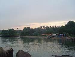 Village on the island | |
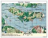
 Pulau Ubin Location of Pulau Ubin within Singapore | |
| Etymology | Granite Island |
| Geography | |
| Location | Southeast Asia |
| Coordinates | 1°24′34″N 103°57′36″E / 1.40944°N 103.96000°ECoordinates: 1°24′34″N 103°57′36″E / 1.40944°N 103.96000°E |
| Archipelago | Malay Archipelago |
| Area | 10.19 km2 (3.93 sq mi) |
| Highest point | Bukit Puaka (75m) |
| Administration | |
| Region | North-East Region |
| Planning Area |
|
| CDC | |
| Town council |
|
| Constituency | |
| Member of Parliament | |
| Demographics | |
| Demonym |
|
| Population | 38 (2012)[1] |
| Ethnic groups |
Chinese Singaporean Malay Singaporean |
| Additional information | |
| Official website | Official website |
Pulau Ubin, also simply known as Ubin, is an island situated in the north east of Singapore, to the west of Pulau Tekong. Granite quarrying supported a few thousand settlers on Pulau Ubin in the 1960s, but only about a hundred villagers live there today. It is one of the last rural areas to be found in Singapore, with an abundance of natural flora and fauna. The island forms part of the Ubin–Khatib Important Bird Area (IBA), identified as such by BirdLife International because it supports significant numbers of visiting and resident birds, some of which are threatened.[2]

Etymology
The name Pulau Ubin literally means "Granite Island" in Malay, which explains the many abandoned granite quarries there. Pulau means "island", and Ubin is said to be a Javanese term for "squared stone". To the Malays, the island is also known as Pulau Batu Ubin, or "Granite Stone Island". The rocks on the island were used to make floor tiles in the past and were called Jubin, which was then shortened to Ubin.
The island is known as tsioh sua in the Taiwanese Romanization of Hokkien, which means "stone hill". The highest point is Bukit Puaka (Puaka Hill) at a height of 75 m.[3]
Legend
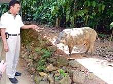
Legend has it that Pulau Ubin was formed when three animals from Singapore (a frog, a pig and an elephant) challenged each other to a race to reach the shores of Johor. The animals that failed would turn to stone. All three came across many difficulties and were unable to reach the shores of Johor. Therefore, the elephant and pig together turned into Pulau Ubin whilst the frog became Pulau Sekudu or Frog Island.[4]
History
Pulau Ubin first appeared on map in an 1828 sketch of the Island of Singapore as Pulo Obin and in Franklin and Jackson's map as Po. Ubin.
Quarries
Since the British founding of Singapore, the island has been known for its granite. The numerous granite quarries on the island supply the local construction industry. The granite outcrops are particularly spectacular from the sea because their grooves and fluted sides create furrows and ridges on each granite rock slab. These features are captured in John Turnbull Thomson's 1850 painting — Grooved stones on Pulo Ubin near Singapore.
The granite from Pulau Ubin was used in the construction of Horsburgh Lighthouse. Tongkangs ferried the huge rock blocks (30 by 20 feet) from the island to Pedra Branca, the site of the lighthouse, in 1850 and 1851.
Later, the granite was also used to build the Singapore-Johor Causeway. Most of the quarries are not in operation today and are being slowly recolonised by vegetation or filled with water. Apart from quarrying, farming and fishing were the principal occupations of the inhabitants of the island in the past. It is also called Selat Tebrau (tebrau is a kind of large fish).
In the 1970s as the granite quarries closed down and jobs dwindled, residents began leaving.[5]
Human settlement

In the 1880s, a number of Malays led by Endut Senin, from the Kallang River were said to have moved to the island that began the thriving Malay community on the island.
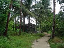
Many of the former kampongs on Pulau Ubin were either named after the first person who settled in the kampong or by some feature in the area. Kampong Leman was named by Leman; Kampong Cik Jawa by a Singaporean named Jawa; and Kampong Jelutong from people from Changi and from its jelutong trees.
During the 1950s and 1970s, there were 2,000 people living on the island[6] and the Bin Kiang School was established in 1952 for the increasing number of children, from money donated by the Chinese resident. Lessons prior to this were conducted on the village wayang stage. With a student population that once numbered 400, enrolment fell as the Singapore mainland developed. The school closed in 1985, and was demolished on 2 April 2000. There was also a private Malay school around 1956 at Kampung Melayu, which closed in the late 1970s.[7]
Pulau Ubin was found to be suitable for the construction of several campsites. Outward Bound Singapore (OBS) was established in 1967 at Pulau Ubin, by Dr Goh Keng Swee, while the National Police Cadet Corps (NPCC) opened its 25-hectare site camp located between Kampung Bahru and Kampung Noordin.[8] The camp is called Camp Resilience where Secondary 2 and 3 NPCC cadets have a 3-day 2 night stay for training. Secondary 2 NPCC cadets go to Adventure Training Camp (ATC) while Secondary 3 NPCC cadets go to Survival Training Camp (STC). lt was opened officially on 10 August 2004.[9]
On 3 June 2005, the Singapore Government ordered that all the farmers rearing poultry on the island were to ship them to mainland Singapore and rear them in government-approved farms by 17 June 2005, in the wake of the avian influenza. In exchange, the local inhabitants were offered HDB government housing packages, although they could choose to live on the island.
As of 2013, there are only a few people living on the island.[6]
Current situation
Pulau Ubin is one of the last areas in Singapore that has been preserved from urban development, concrete buildings and tarmac roads.
Pulau Ubin's wooden house villages and wooden jetties, relaxed inhabitants, rich and preserved wildlife, abandoned quarries and plantations, and untouched nature make it the last witness of the old kampong Singapore that existed before modern industrial times and large-scale urban development.
Ecological projects
Hornbill Conservation Project
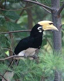
The National Biodiversity Centre, in partnership with Wildlife Reserves Singapore, Nanyang Technological University, and researchers Marc Cremades and Ng Soon Chye, implemented the Hornbill Conservation Project to aid in the breeding and recovery of the Oriental pied hornbill (Anthracoceros albirostris) which had previously became extinct in Singapore but has since started to re-establish itself in places like Pulau Ubin and Changi.[10][11]
Hornbills require tree cavities to nest in. However, tree cavities of sufficient size to accommodate the female hornbill and her young are not common in Singapore. The implementation of artificial nest boxes at Pulau Ubin and Changi have been successful and video cameras are even installed within the nest boxes to provide a better understanding of the behavioural and feeding patterns of these birds.
Seahorse Monitoring Project
Since May 2009, the National Biodiversity Centre, together with volunteers from National Parks Board and nature groups such as Wild Singapore and TeamSeaGrass, initiated a project to monitor identified populations of seahorse (Hippocampus kuda) and pipefish (Syngnathoides biaculeatus) in several locations including Pulau Ubin for conservation management purposes. The data gathered will help to estimate the population size, growth rate of individuals and track their movements in their natural habitats.
Local tourism
Although the island attracted attention for development and planning only in recent years, Singaporean visitors have been visiting Pulau Ubin for summer camps and outdoor activities for many years.
With growing attention and interest in nature, visitors to Pulau Ubin has increased over the years. Pulau Ubin Recreation Area, which included Chek Jawa, was created to cater to local tourism. The site is about 700 hectares within the 1020-hectare Pulau Ubin.
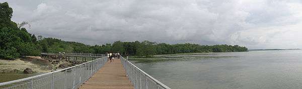
One of the current popular tourist attractions on the island is Chek Jawa. A previous coral reef 5000 years ago, Chek Jawa can be said to be virtually unspoilt, with a variety of marine wildlife comparable to other islands, such as sea hares, sea squirts, octopuses, starfishes, sand dollars, fishes, sponges, cuttlefishes and nudibranches.
A boardwalk runs through the mangrove, allowing visitors to observe the plant and marine life at close range. During low tide, a limited number of people are allowed to walk on the tidal flats.
A local temple, Fo Shan Ting Da Bo Gong Temple, is also another frequently visited site.
Transport
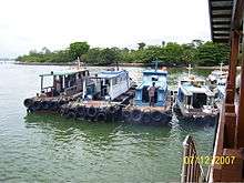
Visitors may travel to Pulau Ubin from the main island of Singapore via a 10-minute bumboat ride from the Changi Point Ferry Terminal (previously known as the Changi Village jetty). In 2008 the one-way ticket price was increased from S$2.00 to S$2.50 per passenger. It was further increased to S$3.00 from 7 September 2015 onwards. Every bumboat can carry 12 passengers and the captain will wait till his boat has reached the maximum capacity. People who do not want to wait can pay S$36.00 for the whole bumboat and leave without waiting.

The rental price for bicycles range anywhere from S$5.00 to S$20.00 (for the entire day) depending on the condition of the bike, number of gears etc.[12]
Mountain biking
Pulau Ubin is home to one of Singapore's mountain bike trails, Ketam Mountain Bike Park which was built in 2007.[13] The trail is approximately 8 kilometers long and features a wide range of terrain ranging from open meadows to thick jungle. There are numerous steep but short climbs and descents. The trail is well-marked with signs indicating the difficulty level of each section.
The vast majority of the mountain bikers that ride this trail bring their own bike, although the rental bikes on the island can also be used. Besides adventurous mountain biking, Pulau Ubin has a lot to offer to recreational mountain bikers with a wide selection of bikes to that can be rented upon arrival. By cruising around the island one can stop by beautiful lakes and other natural spots. It is a great break away from the big and busy city of Singapore.
In popular culture
- In 1989, TCS (now renamed Mediacorp), filmed a television drama named Good Morning, Sir. The drama was set in Post-World War 2 in the 1950s where a woman from the Main Island of Singapore went there to be a Teacher.
- In 1999, MediaCorp filmed a Channel 8 television drama called My Teacher, My Friend about the lives of students in the primary school that used to exist on Pulau Ubin.[14]
- In 2006, Mediacorp broadcast a Kids Central (now Okto) television drama series titled Ubin Boy.[15] The plot revolved around two main characters, Steven (a mainland citizen) and his cousin Ah Boy living in Pulau Ubin.
- In the Danny Wallace book Yes Man, Danny visits Pulau Ubin after it is suggested to him (and to which he must agree) after he visits Singapore. He is told the island is a paradise and must visit it by a local taxi driver.
- The Amazing Race 25 visited this island when the teams arrived in Singapore.
- MediaCorp filmed a Channel 8 television drama called Hand In Hand in 2015 about four siblings in search of a suspicious figure on Pulau Ubin who looks like their father.
Notes
- ↑ "Kampong Life". National Park Boards. 2 January 2018.
- ↑ "Ubin–Khatib". Important Bird Areas factsheet. BirdLife International. 2014. Retrieved 18 March 2014.
- ↑ "Media Factsheet A: About Pulau Ubin" (PDF). National Parks. 30 November 2014. Retrieved 6 December 2015.
- ↑ "Legends of Pulau Ubin". Wild Singapore. Retrieved 19 August 2007.
- ↑ Chua Ee Kiam (2000). Pulau Ubin – Ours to Treasure. p. 39. Simply Green, Singapore. ISBN 981-04-3088-4
- 1 2 "Pulau Ubin: Rustic or just rusting away?". The Straits Times. 6 October 2013.
- ↑ Chua, 2000, p. 36.
- ↑ Chua, 2000. p. 38–39.
- ↑ "Archived copy". Archived from the original on 27 January 2015. Retrieved 30 September 2013.
- ↑ Hornbill Conservation Project Archived 31 January 2010 at the Wayback Machine.
- ↑ Sudden increase in Singapore’s hornbill population Archived 10 June 2010 at the Wayback Machine.
- ↑ http://www.pulauubin.com.sg
- ↑ http://kentridge.eaglet.org/2007/11/16/rock-n-roll-garden/
- ↑ "My Teacher, My Friend". Mediacorp. Retrieved 28 December 2015.
- ↑ "Annual Report 2005/2006 - MDA" (PDF). Media Development Authority. p. 51.
References
Further reading
- A Guide to Pulau Ubin, Singapore Environmental Heritage Series, Mobil Oil Singapore Pte Ltd & The Nature Society (Singapore)
External links
| Library resources about Pulau Ubin |
| Wikimedia Commons has media related to Pulau Ubin. |
- National Parks Board – Pulau Ubin
- Pulau Ubin on wildsingapore latest happenings, how to get there, what to see and do, tips for visitors, galleries.
- Habitatnews blog about the island – Pulau Ubin Stories.
| Art and heritage |
|  |
|---|---|---|
| Coastal | ||
| Community |
| |
| Marine | ||
| Nature | ||
| Nature reserves | ||
| Offshore islands | ||
| Riverine | ||
| Singapore Botanic Gardens | ||
| Southern Ridges | ||
| Defunct | ||