Burnham Overy
| Burnham Overy | |
|---|---|
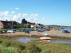 The Staithe | |
 Burnham Overy Burnham Overy shown within Norfolk | |
| Area | 8.92 km2 (3.44 sq mi) |
| Population | 134 (2011) |
| • Density | 15/km2 (39/sq mi) |
| OS grid reference | TF843435 |
| Civil parish |
|
| District | |
| Shire county | |
| Region | |
| Country | England |
| Sovereign state | United Kingdom |
| Post town | KING'S LYNN |
| Postcode district | PE31 |
| Police | Norfolk |
| Fire | Norfolk |
| Ambulance | East of England |
| EU Parliament | East of England |


Burnham Overy is a civil parish on the north coast of Norfolk, England. In modern times a distinction is often made between the two settlements of Burnham Overy Town, the original village adjacent to the parish church and now reduced to a handful of houses, and Burnham Overy Staithe, a rather larger hamlet about 1-mile (1.6 km) away and next to the creek-side harbour.
Burnham Overy lies between the larger village of Burnham Market, less than 1-mile (1.6 km) to the west, and Holkham, some 3 miles (4.8 km) to the east. Burnham Thorpe, the birthplace of Horatio Nelson, lies 1-mile (1.6 km) to the south-east. According to various letters and documents, Nelson learned to row and sail a dinghy at Burnham Overy Staithe, at the age of 10, two years before joining the Navy. The larger town of King's Lynn is 20 miles (32 km) to the south-west, whilst the city of Norwich is 30 miles (48 km) to the south-east.[1]
The civil parish has an area of 8.92 km2 and in the 2001 census had a population of 311 in 167 households, reducing to a population of 134 measured at the 2011 Census.[2] For the purposes of local government, the parish falls within the district of King's Lynn and West Norfolk.[3]
Historically Burnham Overy was the port for the surrounding villages of the Burnhams. Both settlements lie on the River Burn, and until the end of the Middle Ages trading ships were able to reach the village (now Burnham Overy Town). With the silting of the river, commercial traffic switched to the downstream Staithe. With the coming of the railway to the Burnhams in 1866, commercial shipping declined and the last cargo is believed to have been shipped from the Staithe soon after the end of the First World War.[4]
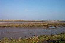
Between Burnham Overy Staithe and the sea, the river spreads out into multiple tidal creeks through the salt marshes that fringe this stretch of coast, and finally reaches the sea by passing through the fronting sand dunes at a gap locally known as Burnham Harbour. Small boats can reach Burnham Overy Staithe through this gap and creek. Today Burnham Overy Staithe, and the associated harbour, is a major recreational sailing centre. It is also the point of departure for ferries to the Scolt Head Island National Nature Reserve.[1][5]
To the east of the Burnham Overy creek, the former salt marshes between dry land and the sand dunes have been reclaimed to form fresh water meadows, part of the Holkham estate. A one-and-a-half-mile (2.4 km) long footpath links Burnham Overy Staithe to the sand-dunes and beach, running along the crest of the embankment which protects these water meadows from the creek.[1]
Notable residents
- Richard Woodget, Captain of the Cutty Sark
In popular culture
In Joan G. Robinson's book When Marnie Was There, the villages of Little Overton and Barnham are based upon Burnham Overy, especially the key locations of the staithe and the windmill.
References
- 1 2 3 OS Explorer Map 251 - Norfolk Coast Central (Map). Ordnance Survey. 2002. ISBN 0-319-21887-2.
- ↑ "Civil parish population 2011". Retrieved 26 August 2015.
- ↑ "Census population and household counts for unparished urban areas and all parishes". Office for National Statistics & Norfolk County Council. 2001. Archived from the original on 2017-02-11. Retrieved 18 October 2005.
- ↑ Burnham Overy Staithe Harbour Trust. Information display at the Staithe.
- ↑ "Coasthopper bus service - Burnham Overy Staithe". Retrieved 2013-02-20.
External links
| Wikimedia Commons has media related to Burnham Overy. |
- Map sources for Burnham Overy
- Photographs of Burnham Overy Staithe
- Tide tables for Burnham Overy Staithe
- Information from NorfolkCoast.co.uk on Burnham Overy.
- Webcam showing the harbour at Burnham Overy Staithe