Obour (city)
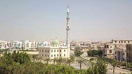
Obour (Arabic: العبور pronounced [ mæˈdiːnɪt el ʕʊˈbuːɾ], meaning "City of the Crossing") is a city in the Qalyubia Governorate, about 35 kilometers north-east of Cairo. The city has approximately 250,000 residents.[1] It is named to honor the crossing ("obour") of the Bar Lev line by the army of Egypt in the Yom Kippur War in 1973.
It is one of 16 new urban areas in Greater Cairo. It is also designated as an industrial zone and houses a number of factories.
Climate
Köppen-Geiger climate classification system classifies its climate as hot desert (BWh),[2] which is very similar to its neighboring area in Cairo and the rest of Egypt.
| Climate data for Obour | |||||||||||||
|---|---|---|---|---|---|---|---|---|---|---|---|---|---|
| Month | Jan | Feb | Mar | Apr | May | Jun | Jul | Aug | Sep | Oct | Nov | Dec | Year |
| Average high °C (°F) | 18.8 (65.8) |
20.7 (69.3) |
24 (75) |
28.4 (83.1) |
32.7 (90.9) |
34.8 (94.6) |
35.1 (95.2) |
34.8 (94.6) |
32.3 (90.1) |
30.1 (86.2) |
25.5 (77.9) |
20.6 (69.1) |
28.2 (82.7) |
| Daily mean °C (°F) | 13.4 (56.1) |
14.6 (58.3) |
17.2 (63) |
20.7 (69.3) |
24.6 (76.3) |
27.1 (80.8) |
27.9 (82.2) |
28 (82) |
25.9 (78.6) |
23.7 (74.7) |
19.8 (67.6) |
15.1 (59.2) |
21.5 (70.7) |
| Average low °C (°F) | 8 (46) |
8.5 (47.3) |
10.5 (50.9) |
13.1 (55.6) |
16.6 (61.9) |
19.5 (67.1) |
20.8 (69.4) |
21.3 (70.3) |
19.5 (67.1) |
17.3 (63.1) |
14.1 (57.4) |
9.6 (49.3) |
14.9 (58.8) |
| Average precipitation mm (inches) | 6 (0.24) |
3 (0.12) |
4 (0.16) |
1 (0.04) |
0 (0) |
0 (0) |
0 (0) |
0 (0) |
0 (0) |
1 (0.04) |
3 (0.12) |
6 (0.24) |
24 (0.96) |
| Source: Climate-Data.org (altitude: 59m)[2] | |||||||||||||
See also
References
- ↑ Grundfos Egypt
- 1 2 "Climate: Al-Obour (altitude: 59m) - Climate graph, Temperature graph, Climate table". Climate-Data.org. Retrieved 2013-12-13.
External links
Districts and suburbs of Greater Cairo | ||||||||||
|---|---|---|---|---|---|---|---|---|---|---|
| Cairo Governorate |
|  | ||||||||
| Giza Governorate |
| |||||||||
| Qalyubia Governorate |
| |||||||||
| 1,000,000 and more | |
|---|---|
| 300,000–999,999 | |
| 100,000–299,999 | |
| <99,999 | |
Coordinates: 30°12′18″N 31°27′27″E / 30.20500°N 31.45750°E
This article is issued from
Wikipedia.
The text is licensed under Creative Commons - Attribution - Sharealike.
Additional terms may apply for the media files.