Kharga Oasis
| Kharga الخارجة ϯⲟⲩⲁϩ `ⲙⲯⲟⲓ | |
|---|---|
 .jpg)   Clockwise from top: Temple of Hibis, Umm Al-Dabadib Fortress, Labkha Palace, Munira Monestry | |
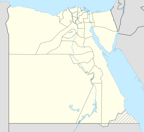 Kharga Location in Egypt | |
| Coordinates: 25°26′56″N 30°32′24″E / 25.44889°N 30.54000°E | |
| Country | Egypt |
| Governorate | New Valley |
| Elevation | 32 m (105 ft) |
| Population (2012) | |
| • Total | 67,700 |
| Time zone | UTC+2 (EST) |
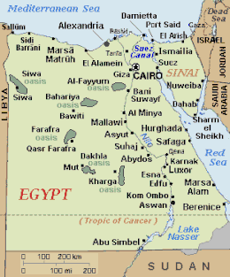
The Kharga Oasis (Egyptian Arabic: الخارجة El Kharga pronounced [elˈxæɾɡæ]) "the outer"; Coptic: (ϯ)ⲟⲩⲁϩ `ⲙⲯⲟⲓ (Di)Wah Ēmpsoy, "Oasis of Psoi") is the southernmost of Egypt's five western oases. It is located in the Western Desert, about 200 km (125 miles) to the west of the Nile valley. "Kharga" or "El Kharga" is also the name of a major town located in the oasis, the capital of New Valley Governorate.[1] The oasis, which was known as the 'Southern Oasis' to the Ancient Egyptians and Oasis Magna to Romans, is the largest of the oases in the Libyan desert of Egypt. It is in a depression about 160 km (100 miles) long and from 20 km (12 miles) to 80 km (50 miles) wide.[2] Its population is 67,700 (2012).
Overview
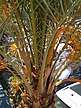
Kharga is the most modernised of Egypt's western oases. The main town is highly functional with all modern facilities, and virtually nothing left of old architecture. Although framed by the oasis, there is no oasis feeling to it; unlike all other oases in this part of Egypt. There is extensive thorn palm, acacia, buffalo thorn and jujube growth in the oasis surrounding the modern town of Kharga. Many remnant wildlife species inhabit this region.
Climate
The Köppen-Geiger climate classification system classifies its climate as hot desert (BWh).[3]
| Climate data for Kharga | |||||||||||||
|---|---|---|---|---|---|---|---|---|---|---|---|---|---|
| Month | Jan | Feb | Mar | Apr | May | Jun | Jul | Aug | Sep | Oct | Nov | Dec | Year |
| Record high °C (°F) | 36.0 (96.8) |
42.3 (108.1) |
47.5 (117.5) |
46.4 (115.5) |
49.8 (121.6) |
50.3 (122.5) |
47.5 (117.5) |
46.8 (116.2) |
45.4 (113.7) |
44.6 (112.3) |
39.8 (103.6) |
38.7 (101.7) |
50.3 (122.5) |
| Average high °C (°F) | 22.1 (71.8) |
24.7 (76.5) |
28.8 (83.8) |
34.5 (94.1) |
38.2 (100.8) |
40.2 (104.4) |
39.9 (103.8) |
39.5 (103.1) |
37.1 (98.8) |
33.9 (93) |
28.1 (82.6) |
23.5 (74.3) |
32.5 (90.5) |
| Daily mean °C (°F) | 14.0 (57.2) |
16.1 (61) |
20.4 (68.7) |
26.1 (79) |
30.3 (86.5) |
32.6 (90.7) |
32.8 (91) |
32.0 (89.6) |
29.0 (84.2) |
26.3 (79.3) |
20.3 (68.5) |
15.5 (59.9) |
24.6 (76.3) |
| Average low °C (°F) | 5.6 (42.1) |
7.1 (44.8) |
11.3 (52.3) |
16.7 (62.1) |
21.5 (70.7) |
24.2 (75.6) |
24.4 (75.9) |
23.2 (73.8) |
22.3 (72.1) |
18.5 (65.3) |
12.5 (54.5) |
7.4 (45.3) |
16.2 (61.2) |
| Record low °C (°F) | 0.0 (32) |
0.2 (32.4) |
2.6 (36.7) |
6.4 (43.5) |
10.6 (51.1) |
14.8 (58.6) |
16.9 (62.4) |
16.9 (62.4) |
14.9 (58.8) |
9.9 (49.8) |
0.8 (33.4) |
0.8 (33.4) |
0.0 (32) |
| Average precipitation mm (inches) | 0 (0) |
0 (0) |
0 (0) |
0 (0) |
0 (0) |
0 (0) |
0 (0) |
0 (0) |
1 (0.04) |
0 (0) |
0 (0) |
0 (0) |
1 (0.04) |
| Average precipitation days (≥ 1.0 mm) | 0 | 0 | 0 | 0 | 0.1 | 0 | 0 | 0 | 0 | 0 | 0 | 0 | 0.1 |
| Average relative humidity (%) | 52 | 45 | 38 | 29 | 27 | 28 | 30 | 31 | 36 | 41 | 47 | 51 | 37.9 |
| Mean monthly sunshine hours | 287.8 | 274.4 | 297.8 | 307.2 | 336.8 | 361.6 | 359.9 | 364.9 | 321.1 | 313.0 | 289.7 | 276.6 | 3,790.8 |
| Source #1: NOAA[4] | |||||||||||||
| Source #2: Climate-Data.org[3] | |||||||||||||
Darb El Arba'īn caravan route
A trade route called Darb El Arba'īn (w:ar:درب الأربعين, "the Way of Forty") passed through Kharga in the south and Asyut in the north. It was a long caravan route running north-south between Middle Egypt and the Sudan. It was used from as early as the Old Kingdom of Egypt for the transport and trade of gold, ivory, spices, wheat, animals and plants.[5] The maximum extent of Darb El Arba'īn was northward from Kobbei in Darfur, 25 miles north of al-Fashir, passing through the desert, through Bir Natrum and Wadi Howar, and ending in Egypt.[6]
All the oases have always been crossroads of caravan routes converging from the barren desert. In the case of Kharga, this is made particularly evident by the presence of a chain of fortresses that the Romans built to protect the Darb El Arba'īn route. The forts vary in size and function, some being just small outposts, some guarding large settlements complete with cultivation. Some were installed where earlier settlements already existed, while others were probably started from scratch. All of them are made of mud bricks, but some also contain small stone temples with inscriptions on the walls.
Described by Herodotus as a road "traversed ... in forty days," by his time the route had already become an important land route facilitating trade between Nubia and Egypt.[7] The length of the journey is the reason for it being called Darb El Arba`īn, the implication being "the forty-day road".[8]
After the prominent Christian theologian Nestorius was condemned as a heretic in the 431 Council of Ephesus, he was removed from his position as Patriarch of Constantinople and exiled to a monastery then located in the Great Oasis of Hibis (El Kharga). There he lived for the rest of his life. The monastery suffered attacks by desert bandits, and Nestorius was injured in one such raid. Nestorius seems to have survived there until at least 450 and there had composed the Bazaar of Heracleides - the only one of writings to survive in full, and of importance to the Christian Nestorians who follow his teachings.
As part of a caravan proceeding to Dafur, the English explorer W.G. Browne paused for several days at Kharga, leaving with the rest of the group 7 June 1793. At the time a gindi was stationed at Kharga, "belonging to Ibrahim Bey El Kebir, to whom those villages appertain; and to [this official] is entrusted the management of what relates to the caravan during the time of its stay there."[9]
In 1930 the archaeologist, Gertrude Caton–Thompson, uncovered the palaeolithic history of Kharga.[10]
Temple of Hibis
See Temple of Hibis
Demographics
Native Khargans belong to the related Beja ethnic group. They speak Beja, their own Afro-Asiatic language, though Arabic is the dominant tongue.
Transportation
A regular bus service connects the oasis to the other Western oases and to the rest of Egypt. In 1907, the narrow gauge Western Oasis Lines provided twice-weekly train services. A standard gauge railway line Kharga - Qena (Nile Valley) - Port Safaga (Red Sea) has been in service since 1996, but has been decommissioned soon after.
Archaeological sites

The Temple of Hibis is a Saite-era temple founded by Psamtik II, which was erected largely c. 500 BC. It is located about 2 kilometres north of modern Kharga, in a palm-grove.[11] There is a second 1st millennium BC temple in the southernmost part of the oasis at Dush.[12] An ancient Christian cemetery at El Bagawat also functioned at the Kharga Oasis from the 3rd to the 7th century AD. It is one of the earliest and best preserved Christian cemeteries in the ancient world.
The first list of sites is due to Ahmad Fakhri but serious archaeological work began in 1976 with Serge Sauneron, director of the Institut Français d'Archéologie Orientale.
- Sites
- Ain El Beleida (Roman)
- Ain El Labakha (Roman)
- Ain Manawir (Persian, Roman)
- Ain Shams El Din (Coptic church)
- Ain El Tarakwa (Roman)
- Ain Tauleib (Roman)
- Deir Mustafa Kashef (Coptic monastery)
- Deir El Munira (Roman)
- Gabbanat El Bagawat (Coptic cemetery)
- Gebel El Teir (Prehistoric times)
- El Nadura (Roman)
- Qasr El Dabashiya (Roman)
- Qasr Dush (Greco-Roman)
- Qasr El Ghuweita (Late Period)
- Qasr El Gibb (Roman)
- Qasr El Zayyan (Greco-Roman)
- Sumeira (Roman)
- Temple of Hibis (Persian - c. 6th century BC.)
- Umm El Dabadib (Roman)
- Umm Mawagir (Middle Kingdom, 2nd Intermediate Period)
Meteorite dagger
In June 2016, a report emerged that attributed the dagger buried with Pharaoh Tutankhamun to an iron meteorite, with similar proportions of metals (iron, nickel and cobalt) to one discovered near and named after Kharga Oasis. The dagger's metal was presumably from the same meteor shower. [13]
Further reading
- Frank Bliss: Artisanat et artisanat d’art dans les oasis du désert occidental égyptien. Frobenius-Institut, Köln, 1998.
- Frank Bliss: Wirtschaftlicher und sozialer Wandel im „Neuen Tal“ Ägyptens. Über die Auswirkungen ägyptischer Regionalentwicklungspolitik in den Oasen der Westlichen Wüste. Bonn, 1989.
- Dunand, Françoise; Ibrahim, Bahgat Ahmed; Hussein, Magdi (2008). Le matériel archéologique et les restes humains de la nécropole d'Aïn el-Labakha (oasis de Kharga) (in French). Cybèle. ISBN 978-2-915840-07-0.
See also
Notes
- ↑ Ball, J. 1900. Kharga Oasis: its topography and geology. Survey Department, Public Works Ministry, Geological Survey Report 1899, Part II. Cairo: National Printing Department, 116 pp.
- ↑ Introduction to Kharga Oasis
- 1 2 "Climate: Kharga - Climate graph, Temperature graph, Climate table". Climate-Data.org. Retrieved 14 August 2013.
- ↑ "Kharga Climate Normals 1961–1990". National Oceanic and Atmospheric Administration. Retrieved 17 January 2016.
- ↑ Jobbins, Jenny. "The 40 days' nightmare," in Al-Ahram, 13–19 November 2003, Issue No. 664. Published in Cairo, Egypt.
- ↑ Burr, J. Millard and Robert O. Collins, Darfur: The Long Road to Disaster, Markus Wiener Publishers: Princeton, 2006, ISBN 1-55876-405-4, pp. 6-7.
- ↑ Smith, Dr. Stuart Tyson. Nubia: History, University of California Santa Barbara, Department of Anthropology, <http://www.anth.ucsb.edu/faculty/stsmith/research/nubia_history.html>. Retrieved 21 January 2009.
- ↑ Richardson, Dan; (1991). EGYPT: the Rough Guide. Harrap Colombus Ltd, Kent. Page ii.
- ↑ Browne, Travels in Africa, Egypt and Syria, from the years 1792 to 1798 (London, 1799), pp. 185
- ↑ L. P. Kirwan, 'Thompson, Gertrude Caton-(1888–1985)', rev. Oxford Dictionary of National Biography, Oxford University Press, 2004
- ↑ "Egyptian Monuments: Hibis". Retrieved 28 November 2008
- ↑ "New Persian temple found at Kharga" Egyptology News 22 February 2007. Retrieved 28 November 2008
- ↑ King Tutankhamun buried with dagger made of space iron, study finds, ABC News Online, 2 June 2016
External links
| Wikimedia Commons has media related to Kharga Oasis. |
- Wilford, John Noble (6 September 2010) "Desert Roads Lead to Discovery in Egypt" The New York Times
- Information on the forts and archaeological work
- Travel guide
- (in German) Khārga on Wikivoyage
Coordinates: 25°26′18″N 30°33′30″E / 25.43833°N 30.55833°E
| 1,000,000 and more | |
|---|---|
| 300,000–999,999 | |
| 100,000–299,999 | |
| <99,999 | |